 Metadata catalogue
Habitats and biotopes
Type of resources
Available actions
Topics
INSPIRE themes
Keywords
Contact for the resource
Provided by
Years
Formats
Representation types
Update frequencies
status
Service types
Scale
Resolution
-
Collation of habitat polygon records contributing to the Geodatabase of Marine features adjacent to Scotland (GeMS). Records are attributed as to their qualification as protected features of protected areas within the Scottish MPA network. Where appropriate typical record details will include: status as Scottish Priority Marine Features or Annex I Habitat, MNCR biotope, EUNIS habitat, date, date range, year, status, accuracy, determiner and details of where the records are sourced from and intellectual property ownership. Polygon area values in the HECTARES field are calculated using ETRS89-LAEA (EPSG:3035) using the standard centre of projection at 10° E, 52° N.
-
From 2010-2012 all known saltmarshes larger than 3ha were surveyed across the Scottish mainland and offshore islands, to compile the first detailed comprehensive national survey of this habitat in Scotland. All saltmarsh and brackish swamp was mapped using the National Vegetation Classification. All mapped areas were digitised to a 1:4,000 scale GIS database. The condition of each saltmarsh site visited was assessed. The primary aims of the Scottish Saltmarsh Survey (SSS) were to obtain information on the morphology, vegetation community structure and species found on saltmarsh sites above 3ha in area or 500m in linear extent.The survey was a joint project between Scottish Natural Heritage (SNH) and the Scottish Environment Protection Agency (SEPA).The saltmarsh survey was tendered in 2009 and awarded to NatureBureau Ltd, who began work on the project in 2010.Detailed report: http://www.snh.gov.uk/publications-data-and-research/publications/search-the-catalogue/publication-detail/?id=2404
-

Les données de séquences brutes qui ont été utilisées pour assembler le génome de l'huître perlière, Pinctada margaritfera
-

-

ddRAD genotyping was used to evaluate population connectivity and putative loci under selection in honeycomb worm from 13 sites spanning its distribution in the Atlantic and Mediterranean coasts.
-
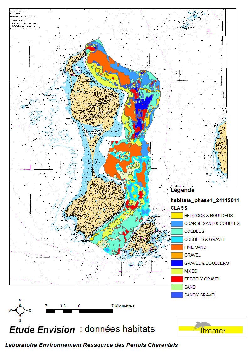
These data were collected during the 2007 and 2011 ENVISION-Ifremer campaigns to sustain a R & D project focusing on the Pectinid aquaculture development. This project was co-funded by the Saint Pierre et Miquelon public body and ODEADOM. This work aims to assess and select new potential rearing areas for the King scallop Placopecten magellanicus by using bottom type data resulting from 2 mapping campaigns carried out in 2007 and 2011 on the Eastern coast of Saint Pierre et Miquelon archipelago.
-

Confidence in the 2016 EUSeaMap Oxygen regime class layer, produced by EMODnet Seabed Habitats for the 2016 EUSeaMap broad-scale predictive habitat maps in the Black Sea. Values are on a range from 1 (Low confidence) to 3 (High confidence). Detailed information on the confidence assessment in Populus J. et al 2017. EUSeaMap, a European broad-scale seabed habitat map. Ifremer. http://doi.org/10.13155/49975
-
Confidence in the 2016 EUSeaMap Energy class layer, produced by EMODnet Seabed Habitats for the 2016 EUSeaMap broad-scale predictive habitat maps. Values are on a range from 1 (Low confidence) to 3 (High confidence). Detailed information on the confidence assessment in Populus J. et al 2017. EUSeaMap, a European broad-scale seabed habitat map. Ifremer. http://doi.org/10.13155/49975
-

We use shotgun metagenomics to reconstruct novel Rimicaris exoculata cephalothoracic epibiotic genomes and unravel their potential metabolic functions
-
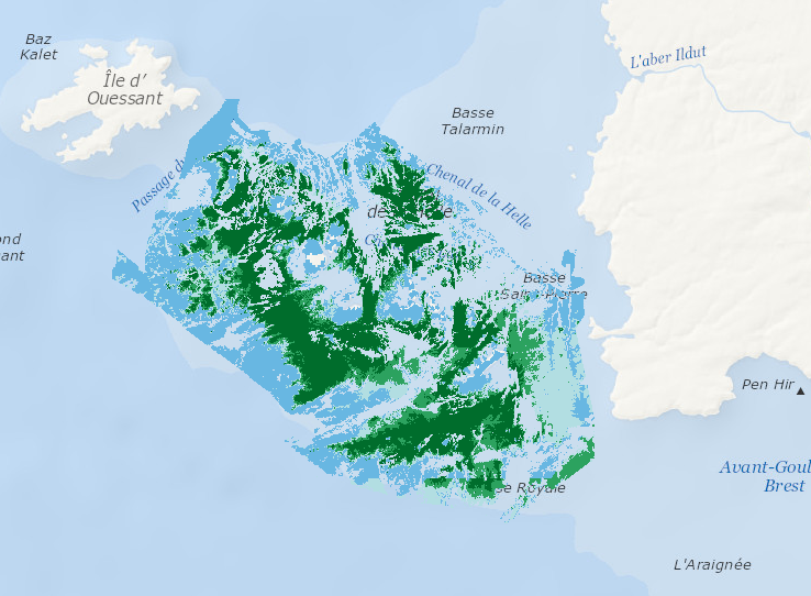
Data represents percentage cover of kelp forest as well as biomass of the 2 main species: L. digitata and L. hyperoborea. The used approach consists in firstly establishing surveys and appropriate processing methods in order to provide a detailed underwater topography of the area and to accurately delineate hard substrates (bedrock) potentially colonized by kelp. Secondly, a habitat suitability model is fitted for each species on some carefully selected field stations, measuring kelp presence/absence and biomass. Predictive maps are produced, based on hard substrate areas previously delineated.