 Metadata catalogue
2010
Type of resources
Available actions
Topics
INSPIRE themes
Keywords
Contact for the resource
Provided by
Years
Formats
Representation types
Update frequencies
status
Service types
Scale
Resolution
-
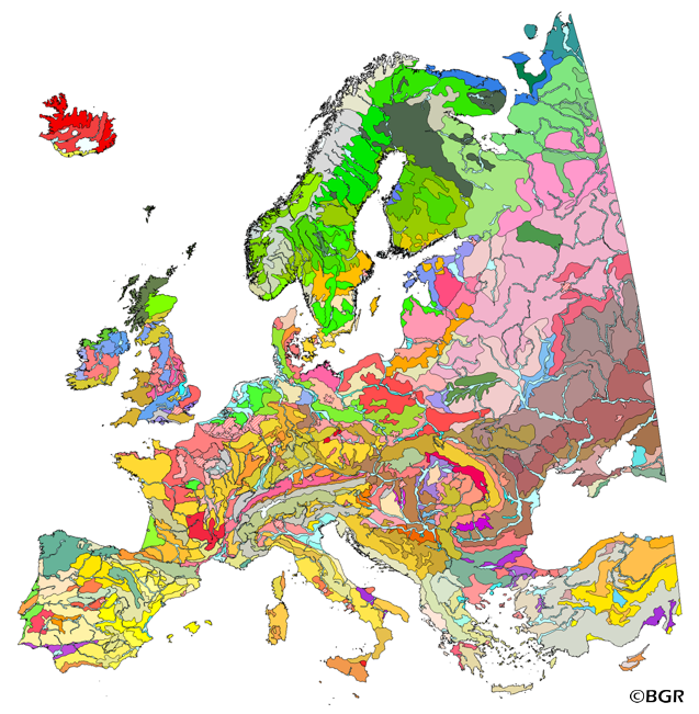
The map of the "Soil Regions of the European Union and Adjacent Countries 1:5,000,000 (Version 2.0)" is published by the Federal Institute of Geosciences and Natural Resources (BGR), in partnership with the Joint Research Center (JRC, Ispra). The soil regions map is intended to support the current national mapping activities towards a European 1:250,000 datbase by stratifying similar regional soil associations into a hierarchical concept. Only by stratification, the complexity of soils can be systematically structured so that the complex 1:250,000 legend can be handled in cross-national and contintental-level applications. Soil regions are natural, cross-regional soil geographical units which perform the highest spatial and content-based aggregation of European soils. They represent the frame conditions for soil development at the landscape level. The soil regions are presented at scale 1:5,000,000. Thus, its borders are highly generalized. Because of its low resolution, the map units absorb atypical soils and associations of soils, which are only described in higher resolution soil maps. The delineation of the soil regions is expected to be refined (and probably improved by its content) during the actual 1:250,000 mapping process. Thus, updating can be expected in the future. Currently, the soil regions map is the only graphical soil representation in Europe which has been developed using fully comparable and harmonized basic data at the continental level (climate, hydrography, relief, geology, vegetation): the interpretation of this input data, and the utilization of expert knowledge (including the interpretation of regional soil maps) has been done using one common methodology, developed and applied consistently throughout the whole mapping area by an experienced international soil mapper (Dr. Reinhard Hartwich, former member of BGR, and co-author of the 1998 Manual of Procedures). The methodology is extensively described in the Explanatory Notes (German), and in the revised Manual of Procedures which is expected to be completed soon. It is highly recommended to apply and interpret the map using the map comments and descriptions as provided in the explanatory notes (German: Hartwich et al. 2005; English: revision of the Manual of Procedures, initial version: Finke et al. 2001).
-
From 2010-2012 all known saltmarshes larger than 3ha were surveyed across the Scottish mainland and offshore islands, to compile the first detailed comprehensive national survey of this habitat in Scotland. All saltmarsh and brackish swamp was mapped using the National Vegetation Classification. All mapped areas were digitised to a 1:4,000 scale GIS database. The condition of each saltmarsh site visited was assessed. The primary aims of the Scottish Saltmarsh Survey (SSS) were to obtain information on the morphology, vegetation community structure and species found on saltmarsh sites above 3ha in area or 500m in linear extent.The survey was a joint project between Scottish Natural Heritage (SNH) and the Scottish Environment Protection Agency (SEPA).The saltmarsh survey was tendered in 2009 and awarded to NatureBureau Ltd, who began work on the project in 2010.Detailed report: http://www.snh.gov.uk/publications-data-and-research/publications/search-the-catalogue/publication-detail/?id=2404
-
A dataset used to display the intrinsic geological and hydrogeological characteristics that determine the ease with which groundwater may be contaminated by human activities.
-
Gives catchment/delineated areas for secondary schools in Angus
-
Properties that Angus Council owns or occupies or has owned or occupied or has some other interest in.
-
Areas where Permitted Development rights under classes 1,7 & 8 of Town Country Planning (General Permitted Development)(Scotland) Order 1992 have been revoked.
-
Local Plan Development Boundaries of villages and towns. Also known as Settlement Boundaries.
-
Community Council Boundaries in Angus
-
Gives current catchment/delineated areas for all primary schools in Angus.
-
The complete listing of all Council houses owned and administered by Angus Council