 Metadata catalogue
1000
Type of resources
Available actions
Topics
INSPIRE themes
Keywords
Contact for the resource
Provided by
Years
Formats
Representation types
Update frequencies
status
Scale
Resolution
-
-
The centralised data storage facilities of the Geological Survey of Finland (GTK) contain altogether 28857 deep drill holes and boreholes to the bedrock. The drillings began in the 1920's and they still continue. The drilling data has been collected to databases since in 1989. The information of drillings which are older than this has been digitised when necessary. The deep drill holes of the bedrock are a spatial data in which the rock sample has been taken from a certain location by drilling. The data contains the information which is related to this sample site and to the core sample. The azimuth, dip and length of the drill hole vary according to the geological environment of the area. The drilling is performed based on the drilling plan drawn up by a geologist. The geologist supervises the drilling site and the realization of the plan and observes and records the information to the database. The following information is saved to the database: the information related to the positioning and location of the drilling, the information about the drilling organization, the information of the storage place of the core sample, the dip of the drill hole, the lithological information of the sample, cutting angle of the structures, the ore minerals and their appearance in the sample, mineral alteration, structure and texture, stratigraphy, core loss, analysed sample intervals and the geochemical analysis results, physical and petrophysical laboratory measurements, drill hole soundings and thin sections. In the deep drill holes the azimuth is determinated in degrees. In the full circle there are 360°. The cardinal azimuth is set to be North (000° or 360°). The hole azimuth is decided by the geologist assisted by geophysical background information and geophysicist. The objective is to get a representative sample of the bedrock units. Hole dip refers to the angle between a horizontal direction and a drilling. The hole dip in the databases of GTK is represented in degrees (°). The dip of the vertical hole is 90°. In horizontal hole the dip is 0°. In that case the drilling has been performed either in a mine or in a quarry or the sample is continuous gouge sample sawed from the bedrock. With respect to the horizontal surface the dip of the drill hole is negative upwards. For example, when a dip is -45° the hole has been drilled in underground mine in the angle of 45 degrees to upwards. The dip of the hole to be drilled is decided by the geologist assisted by geophysical background information and geophysicist. The dip can be presented also as grads. This unit has been used mainly by mining companies. The length of the drilled hole in the databases of the GTK is represented in metres (m). In addition to the drilling plan, the capacity of the drilling machine and the quality of the bedrock affect the length of the drill hole. In the shattered bedrock the hole can be jammed before the objective length. The lengths of the drilled holes vary from 1 metre to 2,5 kilometres. Petrophysical laboratory measurements have been made from the drill core since about the year 1965. Since the year 1963 petrological and ore analyses have been made from the selected core samples. The use of analyses was established and increased at the end of the 1980's with the development of analysis methods. During the present the geochemical analyses are an essential part of the drilling project and are done from all the bore holes, with few exceptions. The type samples representing the lithological units of the area and the sample intervals significant to exploration are selected for analyses. The deep drill holes have been made by the following programmes of the GTK: ore exploration, rock and mineral aggregate studies, natural stone investigations, bedrock mapping and urban mapping. In addition to these, the deep drill holes have been made among others by Outokumpu, Rautaruukki and Lapin Malmi and by the cooperation projects drawn by the universities. The data sets from different sources are not commensurable and information on the quality of the data is partly lacking. The data have been digitised when necessary and a part of the drilling information is still in the paper based archives.
-
Local Development Plan 2015 Settlement Boundaries are used for the distribution of housing and employment land across Moray as per the spatial strategy set out within the Moray Local Development Plan 2015. Settlement boundaries contain the primary, secondary and third tier settlements.
-
Council Register of Assets (Moray). Section 94 of the Community Empowerment (Scotland) Act 2015 (the Act) requires public authorities to make available to members of the public a register of land that it owns or leases “to the best of its knowledge and belief”. The purpose of the register is to help Community Transfer Bodies identify assets that may be available through asset transfer under Part 5 of the Act. The inclusion of an asset on the register is a requirement of the Act and does not necessarily imply that the Council is actively seeking to transfer that asset to the community.
-
-
Vacant and Derelict Land Audit 2016 (Moray) The Scottish Vacant and Derelict Land Survey is a data collection undertaken to establish the extent and state of vacant and derelict land in Scotland. The survey has been operating since 1988, and is managed by the Scottish Government Communities Analysis Division. The data is sourced from local authorities and the Loch Lomond and Trossachs National Park Authority.
-
-
The heat demand is an amalgamation of a number of different spatial datasets that have associated heat demand values. The map has been developed on the principle of applying data with increasing levels of certainty and overlaying and replacing individual property heat demand values. The heat demand layer is made up of a number of rasters which depict this demand in different ways. The heat demand rasters present a visualisation of the heat demand density by showing total demand within grid squares. These are shown at various grid sizes (50x50, 250x250, 500x500 and 1000x1000). The Scotland Heat Map is supported by a number of documents including users guidance which is available at http://www.scotland.gov.uk/heatmap 2.1 Methodology report 2.2 Manual 2.3 Metadata 2.4 Local knowledge validation & improvement process 2.5 Data management 2.6 Limitations and protections for data use and analysis 2.7 Scotland heat map – interactive and local web
-

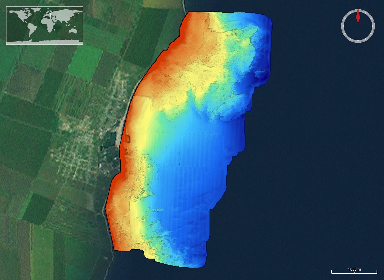
The DTM is produced with Kongsberg multibeam echosounder survey, acquired in March 2020 by Marine Research Ltd. The resolution is 1/256 arc-minutes (~7.2m). It is located at 23 August, Romania, on the coastal region of the Black Sea. Depths are referenced to the Local Sea Level - Marea Neagra 1975 and the coordinates are expressed into the WGS84 reference frame.
-
The DTM is produced with Kongsberg multibeam echosounder survey, acquired in 2015 by Marine Research Ltd. The resolution is 1/256 arc-minutes (~7.2m). It is located in Costinesti, Romania, on the coastal region of the Black Sea. Depths are referenced to the Mean Sea Level and the coordinates are expressed into the WGS84 reference frame.