 Metadata catalogue
asNeeded
Type of resources
Available actions
Topics
INSPIRE themes
Keywords
Contact for the resource
Provided by
Years
Formats
Representation types
Update frequencies
status
Service types
Scale
Resolution
-
Inventory of faults and tectonic boundaries in Brandenburg at regional scale (approx. 1:200.000 - 1:1.000.000)
-
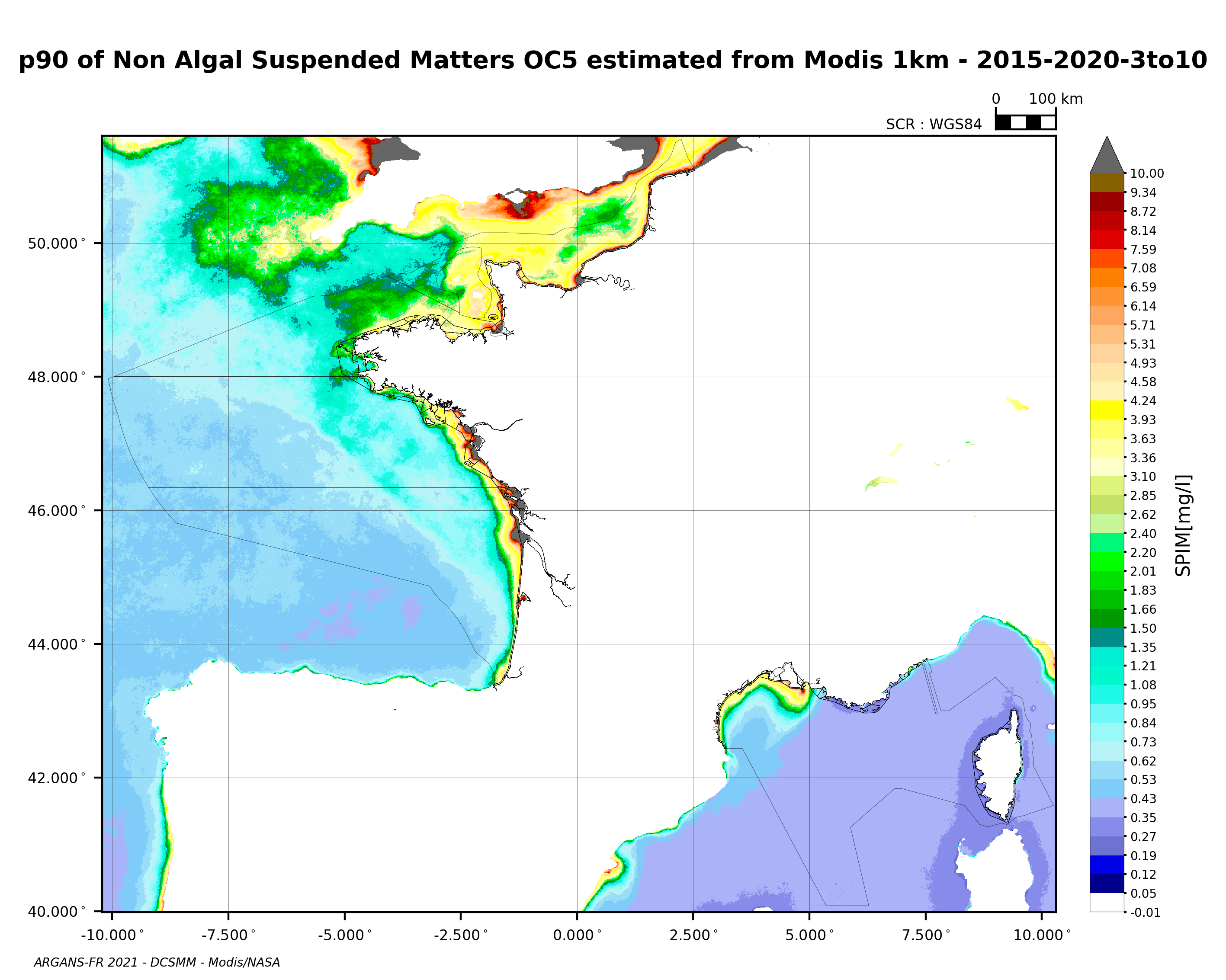
90th percentile of non-algal suspended matter calculated during the productive period of the WFD (March-October) from 2015 to 2020, from the MODIS algorithm processed by OC5 IFREMER/ARGANS (Gohin et al 2002, Gohin 2011).
-
Inventory of faults and tectonic boundaries in Denmark at various regional scales
-
Inspire view service for the data set GE.Bedrock 1:50 000 - 1:250 000
-
This database (SDE) contains state-paid seismic profiles measured in the Czech Republic. Reflection seismic profiles, digitaly registrated, are stored in the SEGY format.The database of this type of profiles contains about 1,000 items. Information about refraction seismic, deep seismic profilling and analogue registred reflection seismic can be found in CGS archieve reports (AGGI).
-
MIN4EU DB consists of two parts: Minerals Inventory data and Minerals Yearbook data. Minerals Inventory covers mineral occurrences and mines in Europe (onshore). The European Union has identified security of supply, improving environmental management and resource efficiency as key challenges for the raw materials sector. Data on the location and spatial distribution of primary and secondary raw materials in relation to exploration, exploitation, production and trading activities form the basis for decision-making in government and industry. Given the dynamic nature of such data, regular updates of comprehensive, reliable and harmonized information across borders are required, as there are several sources of non-harmonized data with different coverages developed over the last decades by national and international projects for different purposes. Data have been prepared and collected in the projects Minerals4EU, EURare, ProSUM, ORAMA, RESEERVE and MINTELL4EU, and others and are shared in the European Geological Data Infrastructure (EGDI).
-
The GEOCR500 dataset was processed completely digitally in ArcGIS 9.1 and integrated within a regional geographic information system.
-
Location of polling places to be used for elections in PKC from 2017 onwards
-
Boundaries for primary school catchment areas excluding Roman Catholic schools
-
There are many areas where the scenery is highly valued locally and local authorities often give these landscapes a local designation. This is to ensure that the landscape is not damaged by inappropriate development, and in some cases encourage positive landscape management. These designations play an important role in developing an awareness of the landscape qualities that make particular areas distinctive and promote a community's sense of pride in their surroundings. The names used for such Local Landscape Areas currently vary from one local authority to another. For example, they are termed 'Areas of Great Landscape Value' in Moray, 'Special Landscape Areas' in Dumfries and Galloway, and 'Sensitive Landscape Character Areas' in Ayrshire. Guidance published by Scottish Natural Heritage and Historic Scotland (see below) suggests the name be standardised to Local Landscape Areas (LLA) now. LLAs complement the National Scenic Area designation, which identifies those landscapes that are seen as nationally important owing to their unsurpassed scenery. http://www.snh.gov.uk/protecting-scotlands-nature/protected-areas/local-designations/local-landscape-areas/