 Metadata catalogue
IFREMER
Type of resources
Available actions
Topics
INSPIRE themes
Keywords
Contact for the resource
Provided by
Years
Formats
Representation types
Update frequencies
status
Service types
Scale
Resolution
-
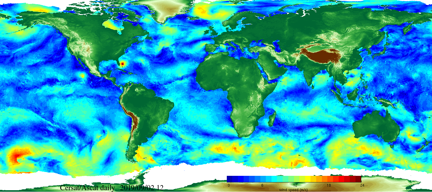
Daily and monthly surface wind analyses are determined as gridded wind products over global oceans, with regular spatial resolution of 0.25° in latitude and longitude. They are estimated from scatterometer wind retrievals (L2b data). According to the scatterometer sampling scheme, the objective method allowing the determination of regular in space surface wind fields uses remotely sensed observations as well as ECMWF analyses. The calculation of daily estimates uses ascending as well as descending available and valid retrievals. The objective method aims to provide daily-averaged gridded wind speed, zonal component, meridional component, wind stress and the corresponding components at global scale. The error associated to each parameter, related to the sampling impact and wind space and time variability, is provided too. Monthly wind analyses are calculated from daily estimates.
-
Bathymetry and seafloor variables at 10-m resolution in the Lacaze-Duthiers Canyon, below130 m depth
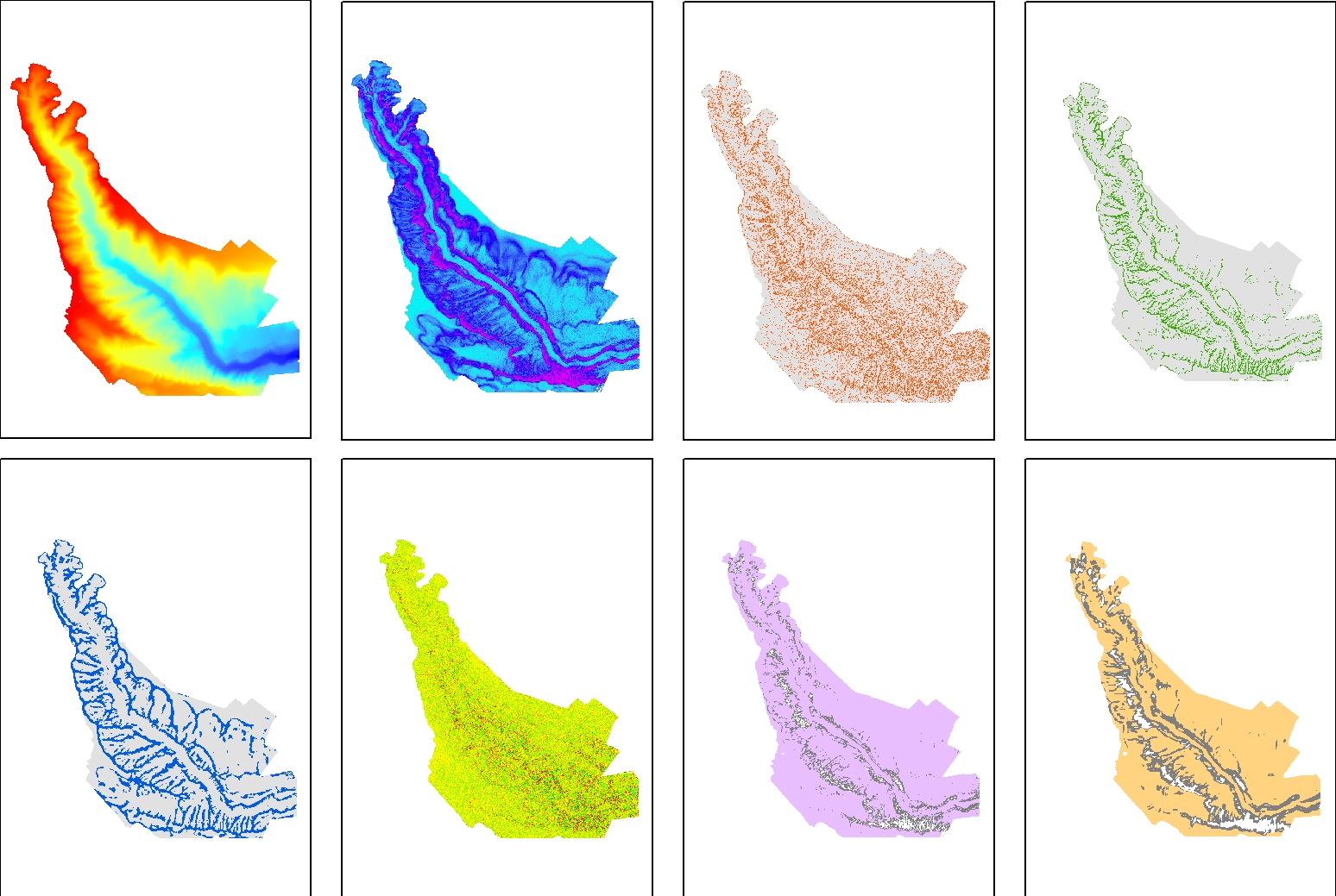
Seafloor variables were derived from the digital terrain models (DTMs) at a 10-m resolution for the entire canyon. The Lacaze-Duthiers Canyon was first delineated, and only data below 130 m depth were retained. The dataset is composed of 12 variables : Bathymetry; Slope; Aspect; Curvature; Surface area to Planar area; Vector Ruggedness Measure (VRM) computed using 9, and 25 pixels; and Bathymetric Position Index (BPI) calculated using windows of 3, 9, 25, 49, and 123 pixels. This dataset was produced to assess the probable distribution of habitats (habitat suitability modeling) for cold-water corals in the Lacaze-Duthiers Canyon at different resolutions as part of the European H2020 project REDRESS (Restoration of Deep-Sea Habitats to Rebuild European Seas, https://redress-project.eu/, Grant Agreement No. 101135492). This dataset is related to the article "Mapping and Conservation of Cold-Water Corals in the Lacaze-Duthiers Canyon for Transboundary Management", submitted to Mediterranean Marine Science by Fabri et al. in 2025.
-
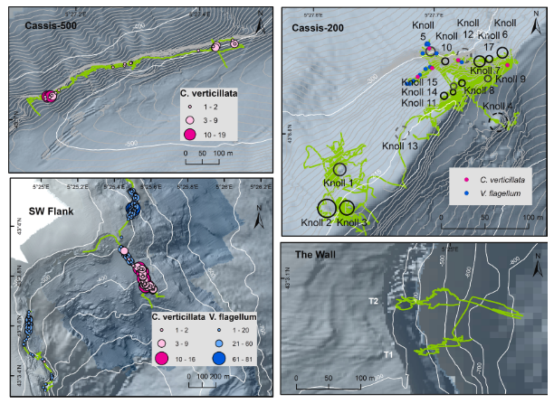
Distribution des gorgonaires Viminella flagellum observées pendant la campagne Videocor1 dans le canyon de Cassidaigne (L'Europe 2017, H-ROV Ariane). Données liées à la publication Fabri et al., 2019. https://doi.org/10.1016/j.pocean.2019.102172
-

Distribution des gorgonaires Callogorgia verticillata observées pendant la campagne VIDEOCOR_2017 dans le canyon de Cassidaigne (L'Europe 2017, H-ROV Ariane). Données liées à la publication Fabri et al., 2019. https://doi.org/10.1016/j.pocean.2019.102172
-
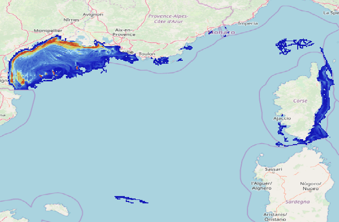
Data on physical impact intensity caused by trawling (bottom otter trawl, twin bottom otter trawl, dredges) estimated from VMS (Vessel Monitoring System) data cross-referenced with the Community Fishing Fleet Register and, for French vessels, with the landing data between 2008 and 2020. The data is constituted of 14 rasters in a resolution of 1’x1’ (13 annual abrasion rasters between 2008 and 2020 and 1 raster representing the 90th percentile of inter-annual abrasion). The abrasion is expressed in swept area ratio per year for each layer. This work enabled the study of the trawling impact on benthic communities in the Gulf of Lions and Corsica. The objective was to better describe the spatial and temporal repartition of trawling in this area and its potential impact on benthic habitats.
-

Daily and monthly surface wind analyses are determined as gridded wind products over global oceans, with regular spatial resolution of 0.25° in latitude and longitude. They are estimated from scatterometer wind retrievals (L2b data). According to the scatterometer sampling scheme, the objective method allowing the determination of regular in space surface wind fields uses remotely sensed observations as well as ECMWF analyses. The calculation of daily estimates uses ascending as well as descending available and valid retrievals. The objective method aims to provide daily-averaged gridded wind speed, zonal component, meridional component, wind stress and the corresponding components at global scale. The error associated to each parameter, related to the sampling impact and wind space and time variability, is provided too. Monthly wind analyses are calculated from daily estimates.
-
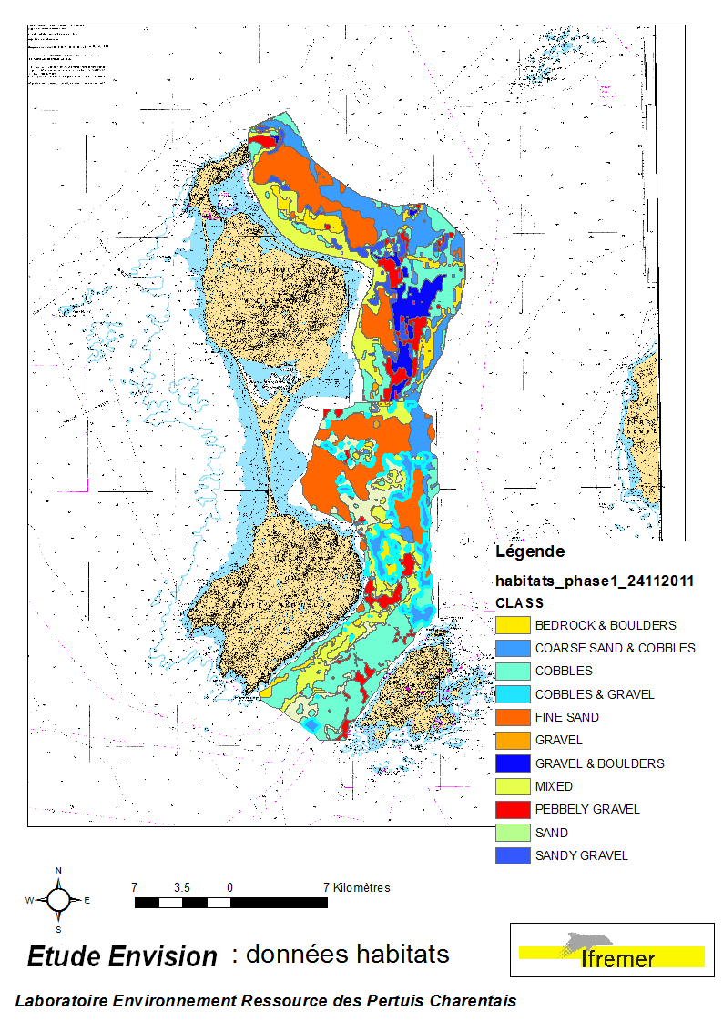
These data were collected during the 2007 and 2011 ENVISION-Ifremer campaigns to sustain a R & D project focusing on the Pectinid aquaculture development. This project was co-funded by the Saint Pierre et Miquelon public body and ODEADOM. This work aims to assess and select new potential rearing areas for the King scallop Placopecten magellanicus by using bottom type data resulting from 2 mapping campaigns carried out in 2007 and 2011 on the Eastern coast of Saint Pierre et Miquelon archipelago.
-

-
La donnée bathymétrique est indispensable pour la mise en place de modèles hydrodynamiques. De nombreuses zones de l'espace maritime calédonien, notamment à faible profondeur, ne sont pas cartographiées. Dans le cadre du projet PRESENCE, des essais de méthodes de calcul de la bathymétrie à partir d'images satellite ont été réalisés. La donnée présentée est le résultat du traitement réalisé sur une image Sentinel 2A de septembre 2017 selon la méthode mise en place par S. Amrari en cours de publication. ATTENTION, CETTE DONNÉE NE DOIT PAS ETRE UTILISÉE POUR LA NAVIGATION
-
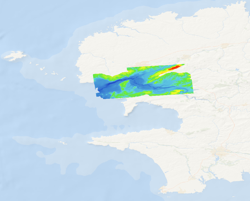
Le modèle numérique de terrain (MNT) du site Natura 2000 de la rade de Brest a été généré grâce à la fusion de données Lidar issues du déploiement du programme Litto3D dans le Finistère ainsi que des levés acoustiques réalisés par l’Ifremer. Ce MNT a été élaboré à une résolution spatiale de 10 m, par un traitement basé sur des méthodes de géostatistique. Ces dernières sont couramment utilisées pour cartographier des variables environnementales telles que la topographie ou la bathymétrie du fond. L’algorithme utilisé est celui du krigeage qui présente l’avantage de palier aux effets de sous-échantillonnage et de sur-échantillonnage, adapté aux données sources utilisées sous la forme de semis de points irréguliers. Ce produit a été généré dans le cadre du projet Natura 2000 Bretagne.