 Metadata catalogue
biota
Type of resources
Available actions
Topics
INSPIRE themes
Keywords
Contact for the resource
Provided by
Years
Formats
Representation types
Update frequencies
status
Scale
Resolution
-
ICES database of trawl surveys
-
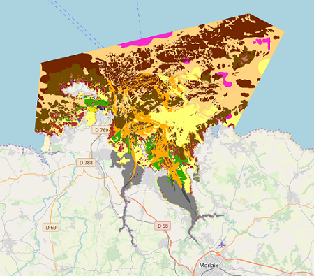
Map of benthic habitat synthesis of the Natura 2000 site FR5300015 - Bay of Morlaix is the result of the fusion and harmonization of five cartographic data. They were generated according to mapping strategies, interpretation scales and on the basis of different cartographic supports.
-

This dataset includes results for the BENTIX, CARLIT and PREI indices. Such data was collected under the EMFF 8.3.1 Project. The monitoring was undertaken in line with Malta's monitoring factsheets for the MSFD Directive.
-

This dataset describes location and area cover for Lithophyllum bissoides platforms along the Maltese coast. Such data was collected under the EMFF 8.3.1 Project. The monitoring was undertaken in line with Malta's monitoring factsheets for the MSFD Directive.
-
Geographical distribution of three nuclear clusters (Q1, Q2, Q3) inferred by a Bayesian clustering analysis (STRUCTURE) after evaluating genetic diversity at nine nuSSR over 217 Jacaranda copaia in five regions in the Neotropics (Western Amazonia, Southern Amazonia, Central Amazonia, Guiana Shield, Central America). For more details, see Scotti-Saintagne et al., 2013 Journal of biogeography vol 40 pp 707-719. This work was funded by the EU-funded INCO “SEEDSOURCE” project, by the EU-funded PO-FEDER “ENERGIRAVI” program and the ANR funded Programme “BRIDGE”
-

The site Yaroupi is composed of four 3km-transects (20m wide). 3965 trees with dbh>=20cm have been recorded by Office national des forêts (ONF). Fauna inventories have been made by Office national de la chasse et de la faune sauvage (ONCFS) few days after. No under-storey plots on this site. Soils have been described using 22 samples (1.20m depth max.). Laboratory analysis are available for one soil-profile.
-

The site Saint Michel is composed of four 3km-transects (20m wide). 3731 trees with dbh>=20cm have been recorded by Office national des forêts (ONF). No fauna inventories. No under-storey plants inventory. Soils have been described using 11 samples (1.20m depth max.). No laboratory analysis available for soils.
-

The site Sables Blancs is composed of two 2.5km-transects (20m wide). 1627 trees with dbh>=20cm have been recorded by Office national des forêts (ONF). No fauna inventories. No under-storey plants inventory. No soil sample has been made on this site. No laboratory analysis available for soils.
-

The map sheet: 1. Carte des principaux groupements de macrophytes benthiques du lagon sud-ouest de Nouvelle Calédonie. Scale of 1:4 000 000 to 1:250 000. Date of publication: unknown.
-

Guyadiv is a network of permanent forest plots installed in French Guiana. The site of Monts d'Arawa is composed of 2 1ha-plots. A complete inventory has been made in 2006 : 1528 trees have been registrated. 512, 480 and 530 species have been identifies respectively on each plot. The percents of trees identified to the species level are : 99.6%, 99.8%, 99.4% on the 3 plots. We only have the point coordinates and not the precise demarcation of the sample plots. In order to calculate the bounding box for these plots, we have expanded the point location 200 meters in each direction.