 Metadata catalogue
5000000
Type of resources
Topics
INSPIRE themes
Keywords
Contact for the resource
Provided by
Years
Formats
Representation types
Update frequencies
status
Scale
Resolution
-

The prawn (Nephrops norvegicus) are common around the Irish coast occurring in geographically distinct sandy/muddy areas were the sediment is suitable for them to construct their burrows. Nephrops spend a great deal of time in their burrows and their emergence from these is related to time of year, light intensity and tidal strength. This is the spatial dataset of the Nephrops Functional Units statistical rectangle sub-division.
-

Survey stations represent the locations where underwater television surveys have taken place during Nephrops Underwater Television (UWTV) surveys. The prawn (Nephrops norvegicus) are common around the Irish coast occurring in geographically distinct sandy/muddy areas were the sediment is suitable for them to construct their burrows. Nephrops spend a great deal of time in their burrows and their emergence from these is related to time of year, light intensity and tidal strength. Areas surveyed for Nephrops burrows include the Aran Grounds, the Irish Sea, Celtic Sea and Porcupine Bank. Nephrops surveys occur annually since 2002. Burrows were surveyed using a standard underwater television camera deployed from the RV Celtic Voyager research vessel. Burrows were counted to support the calculation of the abundance and distribution of Nephrops in the areas identified for populations. Nephrops survey stations deployed by the fisheries science survey team of the Marine Institute (Ireland). Survey stations completed for all UWTV stations.
-

The map sheet: 1. Densité de la population en Afrique Occidentale et Equatoriale : par Circonscriptions Administratives. Scale of 1:5 000 000. Date of publication: unknown.
-
Overview map showing the approximate extent of the key Rare Earth Elements (REE) metallogenic areas in Europe.
-
Overview map showing the approximate extent of the key Lithium metallogenic areas in Europe.
-

The map sheet: 1. L'habitation en Afrique Occidentale et centrale : formes et matériaux : essai. Scale of 1:5 000 000. Date of publication: 1948.
-
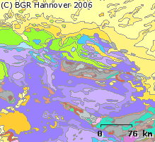
The 1:5 Million International Geological Map of Europe and Adjacent Areas shows the pre-Quarternary geology of Europe onshore and offshore. In addition to the geology attributed by age, petrography and genesis, also magnetic anomalies, tectonic structures, metamorphism and – in the offshore areas – information about the continental/oceanic crust and the continental margin, are shown. The map was developed by BGR under the umbrella of the Commission of the Geological Map of the World (CGMW) and in cooperation with geological surveys organisations of 48 countries and more than 20 research institutes. For detailed information about the 'IGME 5000: More than just a map – A multinational GIS Project' please visit the IGME website.
-
Overview map showing the approximate extent of the key Cobalt metallogenic areas in Europe.
-

A set of 5 map sheets: 1. Bases magnétiques du Niger et du Tchad occidental : valeurs ramenées au 1er janvier 1965 : D : déclinaison. Scale of 1:5 000 000. Date of publication: 1967. 2. Bases magnétiques du Niger et du Tchad occidental : valeurs ramenées au 1er janvier 1965 : F : champ total. Scale of 1:5 000 000. Date of publication: 1967. 3. Bases magnétiques du Niger et du Tchad occidental : valeurs ramenées au 1er janvier 1965 : H : composante horizontale. Scale of 1:5 000 000. Date of publication: 1967. 4. Bases magnétiques du Niger et du Tchad occidental : valeurs ramenées au 1er janvier 1965 : I : inclinaison. Scale of 1:5 000 000. Date of publication: 1967. 5. Bases magnétiques du Niger et du Tchad occidental : valeurs ramenées au 1er janvier 1965 : Z : composante verticale. Scale of 1:5 000 000. Date of publication: 1967.
-

The map sheet: 1. Lenguages indigenas de la Amazonia peruana. Scale of 1:5 000 000. Date of publication: 1998.