 Metadata catalogue
view
Type of resources
Available actions
INSPIRE themes
Keywords
Contact for the resource
Provided by
Years
Formats
Update frequencies
status
Service types
-
Webviewer for the Geological Survey of Ireland, including all publicly accessible databases, including the mineral localities database.
-
Layers relate to: the components of Priority Marine Features (PMF), MPA Search features (Black guillemot or Large-scale features of functional significance used to underpin the selection of Nature Conservation Marine Protected Areas (NC MPA)). Our knowledge about the marine environment, and about which locations should be recommended as MPAs, comes from a range of sources: from targeted surveys led by SNH, JNCC and Marine Scotland focussed on marine habitats and species relevant to Priority marine Features (PMF), survey work conducted by industry, volunteers recording information while enjoying the marine environment for recreation. Information varies from recent to much older. There are a number of different types of data which have been collected using a range of different methods. Data has been placed into a standardised structure to support its use. Depending on who collected them, and for which purpose, some data were in a format we could use immediately while other data needed to be processed before they were able to be used in the Scottish MPA project. The information has been collated in a computer database called GeMS (Geodatabase for Marine Habitats and Species adjacent to Scotland) and has underpinned much of the Scottish Marine Protected Areas process. These layers update and build upon mapping presented in Baxter et al., 2011. Scotland's Marine Atlas: Information for the national marine plan. Marine Scotland, Edinburgh. pp.191
-
This view service provides spatial data relating to population distribution and demography held by the Scottish Government.
-
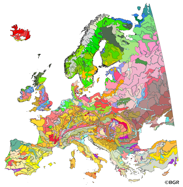
The map of the "Soil Regions of the European Union and Adjacent Countries 1:5,000,000 (Version 2.0)" is published by the Federal Institute of Geosciences and Natural Resources (BGR), in partnership with the Joint Research Center (JRC, Ispra). The soil regions map is intended to support the current national mapping activities towards a European 1:250,000 datbase by stratifying similar regional soil associations into a hierarchical concept. Only by stratification, the complexity of soils can be systematically structured so that the complex 1:250,000 legend can be handled in cross-national and contintental-level applications. Soil regions are natural, cross-regional soil geographical units which perform the highest spatial and content-based aggregation of European soils. They represent the frame conditions for soil development at the landscape level. The soil regions are presented at scale 1:5,000,000. Thus, its borders are highly generalized. Because of its low resolution, the map units absorb atypical soils and associations of soils, which are only described in higher resolution soil maps. The delineation of the soil regions is expected to be refined (and probably improved by its content) during the actual 1:250,000 mapping process. Thus, updating can be expected in the future. Currently, the soil regions map is the only graphical soil representation in Europe which has been developed using fully comparable and harmonized basic data at the continental level (climate, hydrography, relief, geology, vegetation): the interpretation of this input data, and the utilization of expert knowledge (including the interpretation of regional soil maps) has been done using one common methodology, developed and applied consistently throughout the whole mapping area by an experienced international soil mapper (Dr. Reinhard Hartwich, former member of BGR, and co-author of the 1998 Manual of Procedures). The methodology is extensively described in the Explanatory Notes (German), and in the revised Manual of Procedures which is expected to be completed soon. It is highly recommended to apply and interpret the map using the map comments and descriptions as provided in the explanatory notes (German: Hartwich et al. 2005; English: revision of the Manual of Procedures, initial version: Finke et al. 2001).
-
This service contains layers with data from the National Coastal Change Assessment - Dynamic Coast project. The NCCA aims to establish historic coastal change by extracting the georectified coastline position from OS 2nd Edition Country Series maps (1892-1905) and to then compare it to both the 1970’s and current coastal position (updated by LiDAR datasets where available) in order to estimate past erosion/accretion rates. Using the historic coastal change rates the coastline position can then be projected into the future, albeit mediated by a Coastal Erosion Susceptibility Model (CESM) whose function is to limit erosion to areas where the hinterland is susceptible to erosion. The CESM is a national GIS assessment at 50 m raster resolution which models the physical susceptibility of the coast. The model uses a range of data (elevation, rockhead elevation, proximity to the coast, wave exposure, sediment accretion, and coastal defences) which are ranked and amalgamated into a single raster dataset reflecting erosion susceptibility. Using the erosion rates combined with a number of socioeconomic datasets, key assets at risk from future coastal erosion can be identified. The NCCA aims to inform existing strategic planning (Shoreline Management Plans, Flood Risk Management Planning, Strategic and Local Plans, National and Regional Marine Planning etc.) and to also identify those areas which may remain susceptible in the coming decades and require supplementary support. The identification of susceptible assets will enable the development of future management policies and adaptation plans robustly based on a strategic and objective evidence base.
-
The 1:500k lithostratigraphic map covering the whole of the Netherlands is available in this OGC WMS service for all uses - including commercial use subject to the conditions in the Access Constraints section. It is being served as a contribution to the OneGeology initiative (www.onegeology.org). Layers available for superficial geology are age and lithology. In this service these are attributed and coloured according to INSPIRE standards for age and lithology.
-
The web services are developed under the eENVplus project, to provide download service compliant with GeoSciML INSPIRE Data model and to perform pilot demostration.
-
Product by the Pangeo project: http://www.pangeoproject.eu/ PanGeo provides information about the stability of the ground on which we live, work and play. Ground instability, or "geohazards", affect us all. They can be dangerous and costly, yet information on these phenomena can be difficult if not impossible to obtain. The PanGeo service provides entirely free access to geohazard information for many of the largest cities in Europe . The PanGeo service is aimed at local authorities, civil protection agencies, geological surveys, the public, insurers and businesses providing environmental and land reporting services. The service and products available are entirely free to use, even for commercial gain, providing appropriate credits are given (see licence terms). Information in PanGeo is derived from detailed analysis of local geological data combined with satellite measurements of ground movement.
-
Data from the British Geological Survey's GeoIndex Map products theme are made available for viewing here. GeoIndex is a website that allows users to search for information about BGS data collections covering the UK and other areas world wide. Access is free, the interface is easy to use, and it has been developed to enable users to check coverage of different types of data and find out some background information about the data. More detailed information can be obtained by further enquiry via the web site: www.bgs.ac.uk/geoindex.
-
Note: This dataset is designed for the 1:50000 scale but can be viewed in this WMS between 1:100000 and 1:25000 (Only). The 1:50 000 DiGMapGB data covering the whole of the United Kingdom is available in this OGC WMS service for your personal, non-commercial use only. Separate bedrock geology, superficial deposits, artificial ground, mass movement deposits and geological linear features layers are available in this service. For information about more of the British Geological Survey's maps that are available digitally please visit http://www.bgs.ac.uk/products/digitalmaps/digmapgb.html.