 Metadata catalogue
5000
Type of resources
Available actions
Topics
INSPIRE themes
Keywords
Contact for the resource
Provided by
Years
Formats
Representation types
Update frequencies
status
Scale
Resolution
-
This database (SDE) contains state-paid seismic profiles measured in the Czech Republic. Reflection seismic profiles, digitaly registrated, are stored in the SEGY format.The database of this type of profiles contains about 1,000 items. Information about refraction seismic, deep seismic profilling and analogue registred reflection seismic can be found in CGS archieve reports (AGGI).
-
This database contains key information on areas where underground mining or mineral exploration was undertaken in the past. It provides warnings about areas where subsidence or other hazards may occur due to the presence of underground spaces.
-
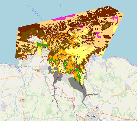
Map of benthic habitat synthesis of the Natura 2000 site FR5300015 - Bay of Morlaix is the result of the fusion and harmonization of five cartographic data. They were generated according to mapping strategies, interpretation scales and on the basis of different cartographic supports.
-
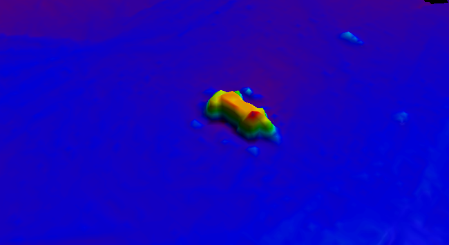
BalticSea_Maritime_Administration_Latvia Wreck found using MBES technique
-
Community Council Boundaries in Moray. The purpose of community councils is to ascertain, co-ordinate and express the views of the community it represents to local authorities and other pubic bodies.
-
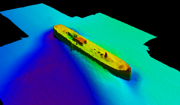
BalticSea_Maritime_Administration_Latvia Wreck found using MBES technique
-

The site Yaroupi is composed of four 3km-transects (20m wide). 3965 trees with dbh>=20cm have been recorded by Office national des forêts (ONF). Fauna inventories have been made by Office national de la chasse et de la faune sauvage (ONCFS) few days after. No under-storey plots on this site. Soils have been described using 22 samples (1.20m depth max.). Laboratory analysis are available for one soil-profile.
-

The site Saint Michel is composed of four 3km-transects (20m wide). 3731 trees with dbh>=20cm have been recorded by Office national des forêts (ONF). No fauna inventories. No under-storey plants inventory. Soils have been described using 11 samples (1.20m depth max.). No laboratory analysis available for soils.
-

The site Sables Blancs is composed of two 2.5km-transects (20m wide). 1627 trees with dbh>=20cm have been recorded by Office national des forêts (ONF). No fauna inventories. No under-storey plants inventory. No soil sample has been made on this site. No laboratory analysis available for soils.
-

Guyadiv is a network of permanent forest plots installed in French Guiana. The site of Monts d'Arawa is composed of 2 1ha-plots. A complete inventory has been made in 2006 : 1528 trees have been registrated. 512, 480 and 530 species have been identifies respectively on each plot. The percents of trees identified to the species level are : 99.6%, 99.8%, 99.4% on the 3 plots. We only have the point coordinates and not the precise demarcation of the sample plots. In order to calculate the bounding box for these plots, we have expanded the point location 200 meters in each direction.