 Metadata catalogue
Data
Type of resources
Available actions
Topics
INSPIRE themes
Keywords
Contact for the resource
Provided by
Years
Formats
Representation types
Update frequencies
status
Service types
Scale
Resolution
-
This service provides an Atom feed of datasets that are available for download.
-
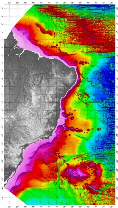
The Digital Terrain Model was developed based on all available bathymetric data, already processed and validated. The SRTM30_PLUS (Shuttle Radar Topography Mission) data were used just to complement the bathymetric grid in distal regions of the Brazilian Continental Margin. In order to prepare the bathymetric grid from a database composed by all qualified bathymetric information, it was adopted the Randgrid.GX/Geosoft - Oasis Montaj®, version 9.5.2, routine. The used mathematical model creates a surface of minimum curvature, using a similar method to that proposed by Swain (1976) and Briggs (1974), with the interpolation, in each knot of the grid, of X and Y values in metric coordinates and Z values (variable). The calculated surface adjusts itself to the irregularly sampled original values. The grid cell-size was 1,000 m, defined according the spatial distribution of the available data. The Brazilian DTM Oasis grid file was converted to surfer files, Versions V6 and V7. The ASCII file and a Geotif image were also provided. The reference system and geodetic datum adopted for the bathymetric data was the WGS84. The projection adopted was the World Mercator (false N=0, false E=0, latitude of the natural origin=0 longitude of the natural origin=0, and the scaling factor of the natural origin=1).
-
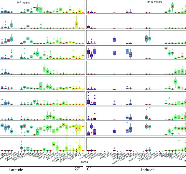
As marine ecosystems are influenced by global and regional processes, standardized information on community structure has become crucial for assessing broad-scale responses to natural and anthropogenic disturbances. Extensive biogeographic provinces, such as the Brazilian Province in the southwest Atlantic, present numerous theoretical and methodological challenges for understanding community patterns on a macroecological scale. In particular, the Brazilian Province is composed of a complex system of heterogeneous reefs and a few offshore islands, with contrasting histories and geophysical-chemical environments. Despite the large extent of the Brazilian Province (almost 8,000 kilometers), most studies of shallow benthic communities are qualitative surveys and/or have been geographically restricted. We quantified community structure of shallow reef habitats from 0° to 27°S latitude using a standard photographic quadrat technique. Percent cover data indicated that benthic communities of Brazilian reefs were dominated by algal turfs and frondose macroalgae, with low percent cover of reef-building corals. Community composition differed significantly among localities, mostly because of their macroalgal abundance, despite reef type or geographic region, with no evident latitudinal pattern. Benthic diversity was lower in the tropics, contrary to the general latitudinal diversity gradient pattern. Richness peaked at mid-latitudes, between 20°S to 23°S, where it was ~3.5-fold higher than localities with the lowest richness. This study provides the first large-scale description of benthic communities along the southwestern Atlantic, providing a baseline for macroecological comparisons and evaluation of future impacts. Moreover, the new understanding of richness distribution along Brazilian reefs will contribute to conservation planning efforts, such as management strategies and the spatial prioritization for the creation of new marine protected areas.
-
This service is an INSPIRE download WFS service, providing UK onshore bedrock geological data at 1:625 000 scale. This map data is collected as part of an ongoing BGS project: Digital Geological Map of Great Britain (DiGMapGB). GeoServer software is used to provide this WFS service. This service is delivering MappedFeatures specified by GeologicUnits, the geological history of which is recorded by GeologicEvents.
-
The 1:50 000 scale GeoSure (natural ground stability) data covering the map sheets for Loughborough and Kilmarnock are available in this OGC WMS service for personal, non-commercial use only. This service is a contribution to the OneGeology-Europe initiative. For information about more of the British Geological Survey's maps and other digital products please visit http://www.bgs.ac.uk/products. MapServer software is used to provide this OGC WMS service.
-
.jpg)
Cruise JR 161 was conducted within the Scotia Sea. Three transects were run as follows: 1. From Stanley in the Falkland Islands to Signy, South Orkneys. 2. From Signy towards the Polar Front North of the Island of South Georgia. 3. From the Polar Front back to Stanley. Nine Stations were sampled in total; we remained on 3 stations for 4 days each and 6 stations for 2 days each. At each station we took samples and measurements to characterise the Oceanography, nutrients, phytoplankton, zooplankton, fish and higher predators. The sampling was undertaken as part of the DISCOVERY 2010 BAS programme, with its remit to investigate and describe the response of the Southern Ocean ecosystem to climate variability, climate change and commercial exploitation.
-
Other fish species caught during the tuna fishing operation that were commercialized. These species were caught along with the target species (tuna) by using pole and line. POPA was launched in 1998 with the main goal of certifying the tuna caught around the Azores as a "dolphin safe product". This label is attributed by the non-governmental organization Earth Island Institute to catches made without mortality of cetaceans. POPA has built an extensive database with information collected by the observers on board the tuna fishing vessels. This database includes information on tuna fisheries (e.g., location of fishing events, catches, and fishing effort), weather conditions (e.g., sea surface temperature, wind and visibility), live bait fisheries (e.g., location of fishing events, catches, gears used), cetaceans (e.g., occurrences, interaction with fishing events and association with other species), birds and sea turtles (e.g., occurrences). POPA is also responsible for "Friend of the Sea" tuna fishery certification. In the late 1990’s, it became clear that the tuna industry would be seriously penalized with the absence of a "dolphin safe" certification which instigated new measures from the government and the fisheries sector. In order to achieve this certification, the Azores Fisheries Observer Programme (POPA) was funded in 1998, ensuring the absence of dolphin mortality or injury in tuna fishery. Since then, fishery and fishing products are certified by the Earth Island Institute, through the results presented by POPA. Besides that, the tuna fishery is also certified as "Friend of the Sea" which means that it is extremely selective, doesn’t harm the surrounding environment and is quite sustainable. It became the first tuna fishery in the world achieving that certification. The Programme results from an agreement among Regional Administration, Earth Island Institute, the Tuna Canning Industry Association (Pão do Mar), the Fishing Boat Owners Association (APASA) and IMAR - Instituto do Mar - through the University of The Azores Center (IMAR-DOP/Uaç), which carries out the programme. Until 2003, the Programme was supported by regional funds. Between 2003 and 2005 it became co-financed by the European Commission through the INTERREG IIIb Programme/ ORPAM project. Since then it has been exclusively supported by the regional government through the Regional Secretary of Fisheries.
-
.jpg)
This was the third cruise undertaken as part of the NERC-funded consortium project (NE/C512961/1) entitled ECOMAR - Ecosystem of the Mid-Atlantic Ridge at the Sub-Polar Front and Charlie Gibbs Fracture Zone. ECOMAR - Ecosystem of the Mid-Atlantic Ridge at the Sub-Polar Front and Charlie Gibbs Fracture Zone. http://www.oceanlab.abdn.ac.uk/ecomar/index.php ECOMAR forms part of the Census of Marine Life MAR-ECO project which is an international study of life in the northern mid-Atlantic Ocean with scientists from 16 nations participating in research of the waters around the mid-Atlantic Ridge from Iceland to the Azores (http://www.mar-eco.no). Depart: Empress Dock, Southampton, UK, Saturday 1 August 2009 Sonar Calibration: Bantry Bay, Ireland, Monday 3 August 2009 Long term moorings were serviced at four super stations at a bottom depth of 2500m equipped with sediment traps, current meters, ADCP and sensor suites, SE - 49°01.92'N, 27°40.82'W, SW - 48°46.80'N, 28°38.43'W, NW - 53°59.33'N, 36°07.39'W and NE 54°00.05'N34°10.58'W. Video and still images of the sea floor were obtained during 18 lander deployments. Faunas samples were taken with 11 megacorer casts, 6 bottom trawls, 8 baited traps and 8 mid-water trawl tows. 23 CTD casts with one 24 h yoyo sequence investigated water masses, flow and primary productivity over the ridge. EK60 acoustic surveys quantified pelagic biomass and optical remote sensing measured patterns of primary productivity and locations of fronts. During work at the SW station the vessel diverted to Cork, Ireland to repatriate personnel on Friday 14th August. Before starting work at the SE station the vessel diverted to 48°45'N 30°23'W in response to a Mayday call from the vessel Black Knight to rescue lone trans-Atlantic rower Peter Bray on Wednesday 19 August. http://www.peterbrayadventurer.com/ http://www.oceanrowing.com/Peter_Bray/dist_map.htm Sonar Calibration: Bantry Bay, Ireland, Monday 7 September 2009 Arrive: Falmouth, UK, Wednesday 9 September 2009 The ECOMAR area will be revisited by the RRS James Cook with the ISIS ROV in 2010.
-
Fish assemblages surveyed by using underwater visual censuses (UVC) down to 40 m. Transects were performed between 1997 and 2015 in the Azores, Portugal. All mobile fish were identified to the lowest possible taxon. Dates, geographic coordinates and species recorded are provided. Fish assemblages were surveyed using underwater visual censuses (UVC) down to 40 m. Following standard belt transect surveys (Brock 1954), SCUBA divers sampled transects with 50 m length and 5 m width. All mobile fish were identified to the lowest possible taxon and counted. Sampling sites were chosen based on the general representativeness of the habitat. Transects within sites were selected by stratified random sampling: different transects were done in each dive without replicating the depth strata (every 10 m) or overall bottom type or crossing transects during a single dive or day. UVCs were conducted in the scope of projects CLIPE (FCT—Praxis XXI/3/3.2/EMG/1957/95), MARÉ (LIFE B4-3200/98-509), MAREFISH (FCT-POCTI/ BSE/41207/2001), OGAMP (INTERREG IIIb/MAC/4.2/A2 2001), MARMAC (INTERREGIIIb-03/MAC/4.2/A1 2004), EmpaFish (EC-FP6, SSP8-006539), MareFish (FCT, POCTI/BSE/41207/2001), MoniZEC (FRC - M2.1.2/I/018/2011)
-
This service is the BGS contribution to the OneGeology project, providing UK onshore geological data at 1:625 000 scale and UK continental shelf seabed sediment data at 1:1 million scale. This map data is collected as part of an ongoing BGS project: Digital Geological Map of Great Britain (DiGMapGB). MapServer software is used to provide these OGC WMS and WFS services.