Metadata catalogue
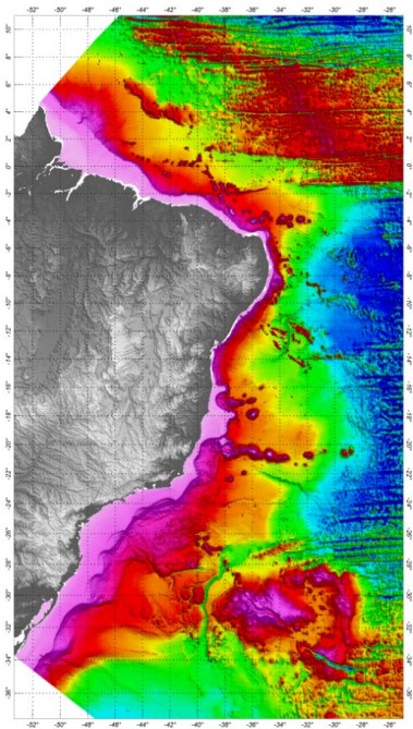
The new Digital Terrain Model (DTM) of the Brazilian Continental Margin: detailed morphology and revised undersea feature names
The Digital Terrain Model was developed based on all available bathymetric data, already processed and validated. The SRTM30_PLUS (Shuttle Radar Topography Mission) data were used just to complement the bathymetric grid in distal regions of the Brazilian Continental Margin.
In order to prepare the bathymetric grid from a database composed by all qualified bathymetric information, it was adopted the Randgrid.GX/Geosoft - Oasis Montaj®, version 9.5.2, routine.
The used mathematical model creates a surface of minimum curvature, using a similar method to that proposed by Swain (1976) and Briggs (1974), with the interpolation, in each knot of the grid, of X and Y values in metric coordinates and Z values (variable). The calculated surface adjusts itself to the irregularly sampled original values. The grid cell-size was 1,000 m, defined according the spatial distribution of the available data.
The Brazilian DTM Oasis grid file was converted to surfer files, Versions V6 and V7. The ASCII file and a Geotif image were also provided.
The reference system and geodetic datum adopted for the bathymetric data was the WGS84.
The projection adopted was the World Mercator (false N=0, false E=0, latitude of the natural origin=0 longitude of the natural origin=0, and the scaling factor of the natural origin=1).
|
|
Citation proposal
A. A. L. Alberoni () - I. K. Jeck () - C. G. Silva () - L. C. Torres () (2019) . The new Digital Terrain Model (DTM) of the Brazilian Continental Margin: detailed morphology and revised undersea feature names. https://services.mspdata.eu:/geonetwork/srv/api/records/8797a901-b492-41c0-9551-e3b291dd3220 |
Simple
- Date ( Publication )
- 2019-11-26
- Identifier
-
8797a901-b492-41c0-9551-e3b291dd3220
- Status
- Completed
Principal investigator
Rua Barão de Jaceguai, s/n° - Ponta da Armação - Niterói
Rio de Janeiro
Brazil
- Website
- https://www.marinha.mil.br/dhn/
Author
Author
Author
Author
- Thèmes Sextant ( Theme )
-
- GEMET - INSPIRE themes, version 1.0 ( Theme )
-
- Mission Atlantic - Resources ( Theme )
-
-
Data
-
- Mission Atlantic - Case Studies ( Theme )
-
-
South Brazilian Shelf
-
- Mission Atlantic - BODC Parameters ( Theme )
-
-
/Marine geology/Gravity, magnetics and bathymetry
-
- Mission Atlantic - Data type (DMP) ( Theme )
-
-
Spatial data products
-
- Use constraints
- Copyright
- Spatial representation type
- Grid
- Distance
- 1000 meter
- Metadata language
- English
- Character set
- UTF8
- Topic category
-
- Oceans
))
- Reference system identifier
-
EPSG
/WGS 84 / World Mercator (EPSG:3395)
/7.4
- Geometric object type
- Surface
- OnLine resource
- Fisiografia da margem brasileira
- Hierarchy level
- Dataset
Metadata
- File identifier
- 8797a901-b492-41c0-9551-e3b291dd3220 XML
- Metadata language
- English
- Character set
- UTF8
- Hierarchy level
- Dataset
- Date stamp
- 2021-12-08T13:44:52
- Metadata standard name
-
ISO 19115:2003/19139 - SEXTANT
- Metadata standard version
-
1.0
Publisher
- Website
- https://sextant.ifremer.fr/eng