 Metadata catalogue
1995
Type of resources
Available actions
Topics
INSPIRE themes
Keywords
Contact for the resource
Provided by
Years
Formats
Representation types
Update frequencies
status
Service types
Scale
Resolution
-
This data layer is the BGS contribution to the OneGeology project, providing UK onshore geological data at 1:625 000 scale and UK continental shelf seabed sediment data at 1:1 million scale. This map data is collected as part of an ongoing BGS project: Digital Geological Map of Great Britain (DiGMapGB). This layer is the seabed sediment data layer.
-
This service is an INSPIRE download WFS service, providing UK onshore bedrock geological data at 1:625 000 scale. This map data is collected as part of an ongoing BGS project: Digital Geological Map of Great Britain (DiGMapGB). GeoServer software is used to provide this WFS service. This service is delivering MappedFeatures specified by GeologicUnits, the geological history of which is recorded by GeologicEvents.
-
The 1:50 000 scale GeoSure (natural ground stability) data covering the map sheets for Loughborough and Kilmarnock are available in this OGC WMS service for personal, non-commercial use only. This service is a contribution to the OneGeology-Europe initiative. For information about more of the British Geological Survey's maps and other digital products please visit http://www.bgs.ac.uk/products. MapServer software is used to provide this OGC WMS service.
-
This service is the BGS contribution to the OneGeology project, providing UK onshore geological data at 1:625 000 scale and UK continental shelf seabed sediment data at 1:1 million scale. This map data is collected as part of an ongoing BGS project: Digital Geological Map of Great Britain (DiGMapGB). MapServer software is used to provide these OGC WMS and WFS services.
-
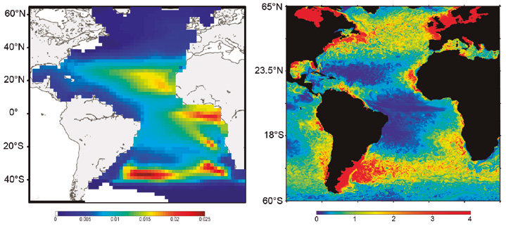
SEAPODYM has been initiated in the mid-1990s by the Oceanic Fisheries Programme of the Secretariat of the Pacific Community (SPC) and developed under several European development projects. The objective was to propose new management tools taking into account both the fishing impact and environmental variability. Since 2006, in partnership with SPC, its development has continued with the Marine Ecosystem Modeling team of CLS (Collecte Localisation Satellite). CLS aims to combine this modeling approach with satellite observation and real-time data collection to develop operational real-time applications and advise government administrations on the sustainable management and monitoring of marine resources. The main features of SEAPODYM framework are: - Prediction of the temporal and spatial distributions of functional lower and mid-trophic level groups (Lehodey et al. 2010; 2015) - Prediction of the temporal and spatial distributions of age-structured predator (fish) populations (Lehodey et al. 2008); - Prediction of the total catch and the size-frequency of catch by fishing fleet; - Parameter optimization based on data assimilation techniques (Senina et al., 2008); The lower and mid-trophic level (LMTL) sub-model describes the dynamics of a functional group of zooplankton and several vertically migrant and non-migrant micronekton (prey of larger fish) groups. The dynamics are linked to temperature and currents. Assimilation of acoustic or biomass data is used to estimate the model parameters. The dynamics of fish populations are estimated using habitat indices, movements, growth and mortality. The feeding habitat is based on the accessibility of fish to the groups of prey. The spawning habitat combines temperature preference and coincidence of spawning with presence or absence of predators and food for larvae. Successful larval recruitment is linked to spawning stock biomass and mortality during the drift with currents. Older fish can swim along the gradient of habitat index in addition to being advected by ocean currents.
-
Monumentos nacionais classificados em Diário da República, no concelho de Matosinhos.
-
Eixos de via do concelho de Matosinhos, criados em 1995 e constantemente actualizados. Feitos com base em cartografia à escala 1:1000.
-
Imóveis de valor concelhio classificados em Diário da República, no concelho de Matosinhos.
-
Magnetic map (K. Šalanský, 1995) of the Czech Republic in a scale 1 : 500,000 (GEOCR500) in the izanomal T (Z) form. Selected basic interval of isolines of 25 n T represents sufficiently accurately the course of the magnetic field. The map si complemented by the list of reports where are noticed basis which were used for the preparation of magnetic maps. The map is complemented by the selection of literature for interpretation of magnetic anomalies.
-
Radiometric map of the Czech Republic (M. Manová, M. Matolín,1995) describes the natural radioactivity of the rocks on the Earth's surface. The radioactivity field is expressed in a batch a dose rate of gamma radiation of rocks 1 m above the Earth's surface. Map data defines the regions of low and high radioactivity.