 Metadata catalogue
CLS
Type of resources
Available actions
Topics
INSPIRE themes
Keywords
Contact for the resource
Provided by
Years
Representation types
status
-
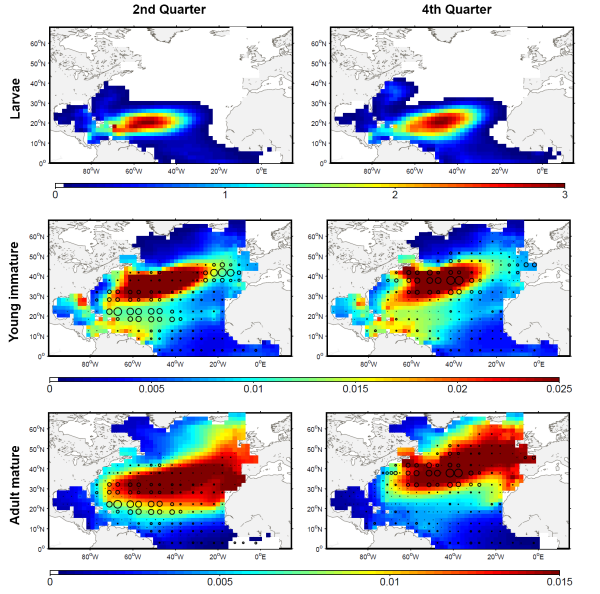
The development of the ecosystem approach and models for the management of ocean marine resources requires easy access to standard validated datasets of historical catch data for the main exploited species. They are used to measure the impact of biomass removal by fisheries and to evaluate the models skills, while the use of standard dataset facilitates models inter-comparison. North Atlantic albacore tuna is exploited all year round by longline and in summer and autumn by surface fisheries and fishery statistics compiled by the International Commission for the Conservation of Atlantic Tunas (ICCAT). Catch and effort with geographical coordinates at monthly spatial resolution of 1° or 5° squares were extracted for this species with a careful definition of fisheries and data screening. In total, thirteen fisheries were defined for the period 1956-2010, with fishing gears longline, troll, mid-water trawl and bait fishing. However, the spatialized catch effort data available in ICCAT database represent a fraction of the entire total catch. Length frequencies of catch were also extracted according to the definition of fisheries above for the period 1956-2010 with a quarterly temporal resolution and spatial resolutions varying from 1°x 1° to 10°x 20°. The resolution used to measure the fish also varies with size-bins of 1, 2 or 5 cm (Fork Length). The screening of data allowed detecting inconsistencies with a relatively large number of samples larger than 150 cm while all studies on the growth of albacore suggest that fish rarely grow up over 130 cm. Therefore, a threshold value of 130 cm has been arbitrarily fixed and all length frequency data above this value removed from the original data set.
-
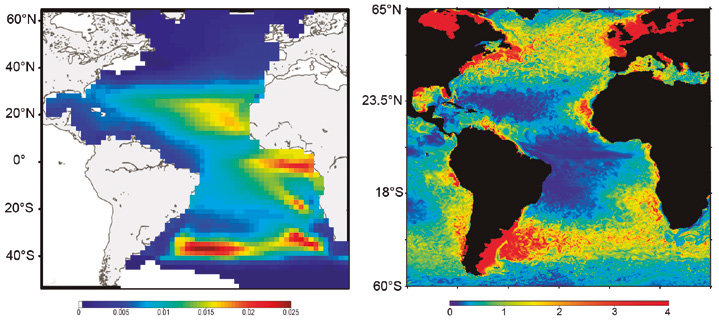
SEAPODYM has been initiated in the mid-1990s by the Oceanic Fisheries Programme of the Secretariat of the Pacific Community (SPC) and developed under several European development projects. The objective was to propose new management tools taking into account both the fishing impact and environmental variability. Since 2006, in partnership with SPC, its development has continued with the Marine Ecosystem Modeling team of CLS (Collecte Localisation Satellite). CLS aims to combine this modeling approach with satellite observation and real-time data collection to develop operational real-time applications and advise government administrations on the sustainable management and monitoring of marine resources. The main features of SEAPODYM framework are: - Prediction of the temporal and spatial distributions of functional lower and mid-trophic level groups (Lehodey et al. 2010; 2015) - Prediction of the temporal and spatial distributions of age-structured predator (fish) populations (Lehodey et al. 2008); - Prediction of the total catch and the size-frequency of catch by fishing fleet; - Parameter optimization based on data assimilation techniques (Senina et al., 2008); The lower and mid-trophic level (LMTL) sub-model describes the dynamics of a functional group of zooplankton and several vertically migrant and non-migrant micronekton (prey of larger fish) groups. The dynamics are linked to temperature and currents. Assimilation of acoustic or biomass data is used to estimate the model parameters. The dynamics of fish populations are estimated using habitat indices, movements, growth and mortality. The feeding habitat is based on the accessibility of fish to the groups of prey. The spawning habitat combines temperature preference and coincidence of spawning with presence or absence of predators and food for larvae. Successful larval recruitment is linked to spawning stock biomass and mortality during the drift with currents. Older fish can swim along the gradient of habitat index in addition to being advected by ocean currents.