 Metadata catalogue
document
Type of resources
Available actions
Topics
INSPIRE themes
Keywords
Contact for the resource
Provided by
Years
Formats
Representation types
status
-
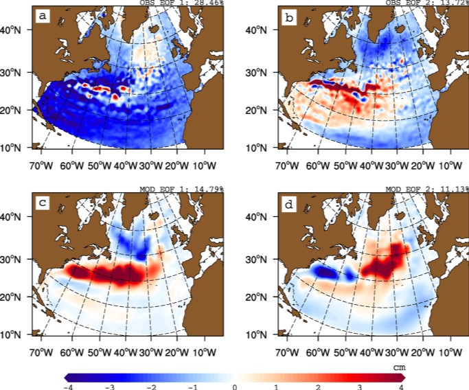
The gyre index constructed here from satellite altimetry is related to core aspects of the North Atlantic subpolar gyre, meridional overturning circulation, hydrographic properties in the Atlantic inflows toward the Arctic, and in marine ecosystems in the northeast Atlantic Ocean. The data series spans the period January 1993 to September 2018. Data description: Monthly gyre index from January 1993 until September 2018. The data is provided in one comma separated value (csv) file with the following entries on each row: year, month, index value. The index is normalized, i.e. it has a zero mean and unit standard deviation. Positive (negative) gyre index reflects stronger (weaker) than average surface circulation of the North Atlantic subpolar gyre.
-

We assembled a dataset of 14C-based productivity measurements to understand the critical variables required for accurate assessment of daily depth-integrated phytoplankton carbon fixation (PP(PPeu)u) from measurements of sea surface pigment concentrations (Csat)(Csat). From this dataset, we developed a light-dependent, depth-resolved model for carbon fixation (VGPM) that partitions environmental factors affecting primary production into those that influence the relative vertical distribution of primary production (Pz)z) and those that control the optimal assimilation efficiency of the productivity profile (P(PBopt). The VGPM accounted for 79% of the observed variability in Pz and 86% of the variability in PPeu by using measured values of PBopt. Our results indicate that the accuracy of productivity algorithms in estimating PPeu is dependent primarily upon the ability to accurately represent variability in Pbopt. We developed a temperature-dependent Pbopt model that was used in conjunction with monthly climatological images of Csat sea surface temperature, and cloud-corrected estimates of surface irradiance to calculate a global annual phytoplankton carbon fixation (PPannu) rate of 43.5 Pg C yr‒1. The geographical distribution of PPannu was distinctly different than results from previous models. Our results illustrate the importance of focusing Pbopt model development on temporal and spatial, rather than the vertical, variability.
-

The largest landings in this ecoregion are by Norway, the Russian Federation (Russia henceforth), Faroe Islands, and Iceland, mainly by pelagic fisheries. Other nations also have fisheries in the area. The number of fishing vessels is declining while the size of the remaining vessels is increasing. The annual catch in the ecoregion has varied between 700 000 tonnes to over 2 million tonnes. The pelagic fisheries, using purse seine and pelagic trawls, account for the largest catches by weight and target herring (her.27.1-24a514a), blue whiting (whb.27.1-91214), mackerel (mac.27.nea), and other pelagic species. The largest demersal fishery targets cod (cod.27.1-2), haddock (had.27.1-2), and saithe (pok.27.1-2) using bottom trawls, purse seine, Danish seine and gillnets, and to a lesser extent hook and line gear. Smaller fisheries target other gadoid species, Greenland halibut (ghl.27.1-2), and redfish. Landings of pelagic species within the ecoregion in the last decades have been variable. The demersal fisheries, dominated by cod, display less pronounced fluctuations than the pelagic fisheries. Information about discards is sparse, but the total weight of discards is considered low in both the pelagic and the demersal fisheries. Harp seals and minke whales are hunted in the region. Status summary of Norwegian Sea stocks relative to the ICES maximum sustainable yield (MSY) approach and precautionary approach (PA) is known for 50% of the 23 stocks assessed by ICES in this ecoregion. Only 22% of the stocks are fished below FMSY, accounting for nearly 13% of the total catch. 30% of the stocks have a biomass above MSY Btrigger, accounting for 86% of the total catch. Demersal stocks have shown a trend of declining fishing mortality since the mid-1990s, and the average F/FMSY ratio is now close to 1. The mean SSB/MSY Btrigger ratio of demersal stocks has been decreasing over the last decade, but mean SSB remains above MSY Btrigger. The average F/FMSY ratio for pelagic stocks has been decreasing since 2000 and is now close to 1. The mean SSB/MSY Btrigger ratio for pelagic species has shown a slight increase over the last two decades and is above 1. In addition to biomass removal, ecosystem effects of fisheries include abrasion, ghost fishing, and bycatch of protected, endangered, and threatened species.
-

The objective of the DTOceanPlus project was to develop a software suite of open source advanced tools for the selection, development and deployment of ocean energy systems. DTOceanPlus project made it to develop and demonstrate an open source sotftware suite of second generation design tools for ocean energy technologies including sub-systems, energy capture devices and arrays. These tools support the entire technology innovation process, from concept, through development, to deployment. More broadly, the project also provided an industry standard for communicating technology descriptions throughout the sector. To complement the numerical work, an extensive market analysis of the ocean energy sector is publicly available.
-
The DTOceanPlus project has develop an open-source integrated suite of 2nd generation design tools for ocean energy technologies. The tools support the entire technology innovation and advancement process from concept, through development, to deployment, and is applicable at a range of levels: sub-system, device, and array. As one of the first tasks in the project, researchers at The University of Edinburgh conducted a consultation exercise, with the support of DTOceanPlus partners. This consultation addressed potential users and other key stakeholders for the DTOceanPlus tools, to identify and clarify their needs and requirements. A webinar was held initially, to introduce both the DTOceanPlus tools and the consultation. In addition to an online questionnaire, a series of individual interviews were held to obtain more nuanced input from key stakeholders. Opinions from over 70 industry professionals from a wide range of backgrounds were collated and analysed as part of the consultation. This includes representation of the four stakeholder categories identified: - Public funders, commercial investors, and insurance providers, - Innovators and developers, - Project developers, utilities, and supply chain, and - Policy makers, regulators, and standardisation bodies. Of the overall software characteristics considered, usability followed by flexibility & expandability then modularity were seen as most important. The proposed tools will need to deal with varying degrees of complexity, both at different stages in the project lifecycle and also for different user requirements. Several responses stressed the importance of linkages between the tools, and with external software. Nearly all respondents (>85%) indicated that they were likely or very likely to use DTOceanPlus at some stage in the project lifecycle. The results from the consultation exercise are presented in this report.
-

The objectives of the DUNES project are on the one hand to understand the sedimentary and ecosystem dynamics of underwater dunes, and on the other hand to provide technology developers and industrialists in the ORE sector with complementary knowledge and approaches to work in environments with hydraulic dunes. The expected results are first of all to have a better knowledge of the physical processes and the natural functioning of hydraulic dunes, to create a free access GIS dedicated to dune fields and sandbanks, to characterize on a fine scale of the structure of food webs in dunes to understand the functioning of these particular systems, and finally to establish methodological recommendations regarding the evaluation of anthropogenic impacts on dune ecosystems.
-
Assessments run at AFWG provide the scientific basis for the management of cod, haddock, saithe, redfish, Greenland halibut and capelin in subareas 1 and 2. Taking the catch values provided by the Norwegian fisheries ministry for Norwegian catches1 and raising the total landed value to the total catches gives an approximate nominal first-hand landed value for the combined AFWG stocks of ca. 20 billion NOK or ca. 2 billion EUR (2018 estimates).
-

The objective of the ABIOP project was to develop biofouling characterisation and quantification methods to make the design and maintenance of ORE systems more reliable. ABIOP has identified the research needs that will enable better identification and management of the risks relating to the ORE components most sensitive to biofouling. Initial in situ measurements were also carried out to characterise biocolonisation in the Atlantic and Mediterranean from an engineering and environmental point of view. The necessary additional studies are being carried out within the framework of the ABIOP+ project.
-

The objective of the PHYSIC project was to develop hydrosedimentary modeling in areas of strong currents through measurement campaigns. PHYSIC made it possible to establish recommendations for the deployment of equipment for the acquisition of field data in areas of strong currents. Databases dealing with sediment transport in the Raz Blanchard have also been set up. They represent valuable tools for those involved in the tidal stream industry.
-
A coherent set of functional and technical requirements have been developed for the DTOceanPlus suite of design tools based on analysis of gaps between the current state-of-the-art tools, learning from the original DTOcean project, and the stakeholder expectations identified in the user consultation survey. The technical requirements in this document are translated from the general requirements for the overall suite of tools, and specific requirements (functional, operational, user, interfacing, and data) for the Structured Innovation design tool that has been developed as part of this project. These requirements relate to detailed technical requirements of the technology and environment, for the development, maintenance, support and execution of the software specifications to best meet the needs of the ocean energy industry.