 Metadata catalogue
map
Type of resources
Available actions
Topics
INSPIRE themes
Keywords
Contact for the resource
Provided by
Years
Formats
Representation types
Update frequencies
status
Scale
-
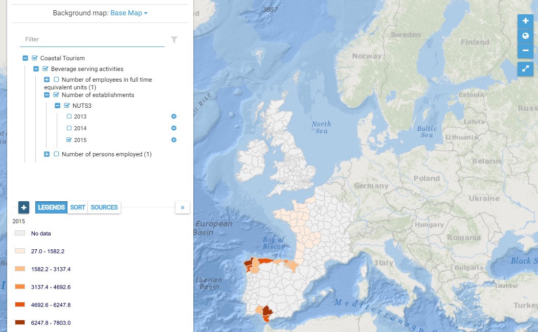
This map presents all layers corresponding to "Beverage serving activities" activities in the Atlantic area. For more information about this NACE code : https://ec.europa.eu/eurostat/ramon/nomenclatures/index.cfm?TargetUrl=DSP_NOM_DTL_VIEW&StrNom=NACE_REV2&StrLanguageCode=EN&IntPcKey=18514154&IntKey=18514184&StrLayoutCode=HIERARCHIC&IntCurrentPage=1 Indicators collected are : Number of persons employed and number of employees in full time equivalent units per NUTS 3 unit of the Atlantic Area Number of establishments per NUTS3 unit of the Atlantic Area
-
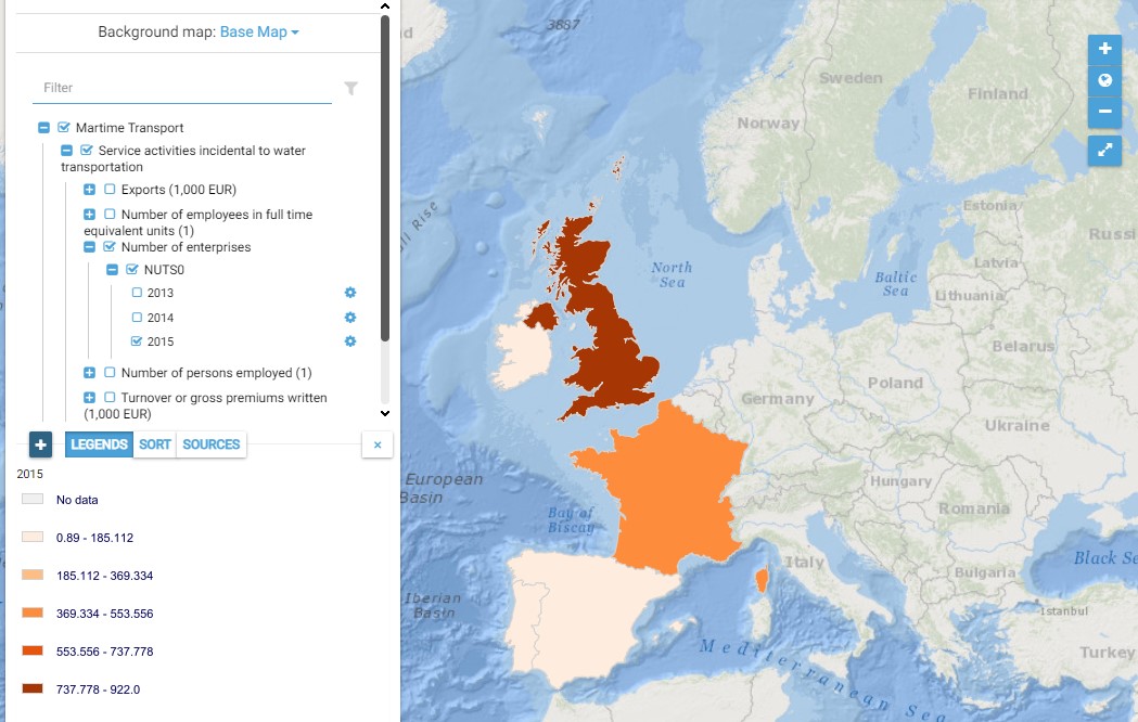
This map presents all layers corresponding to "Service activities incidental to water transportation" activities in the Atlantic area. For more information about this NACE code : https://ec.europa.eu/eurostat/ramon/nomenclatures/index.cfm?TargetUrl=DSP_NOM_DTL_VIEW&StrNom=NACE_REV2&StrLanguageCode=EN&IntPcKey=18513344&IntKey=18513404&StrLayoutCode=HIERARCHIC&IntCurrentPage=1 Indicators collected are : Business indicators per country Number of persons employed and number of employees in full time equivalent units per NUTS 3 unit of the Atlantic Area
-
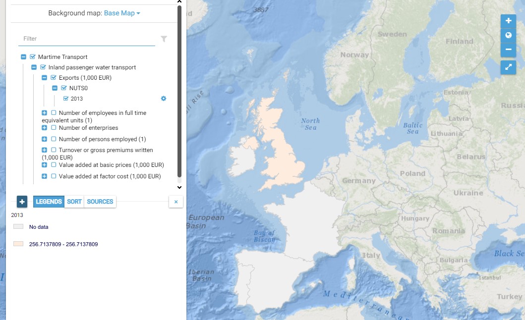
This map presents all layers corresponding to "Inland passenger water transport" activities in the Atlantic area. For more information about this NACE code : https://ec.europa.eu/eurostat/ramon/nomenclatures/index.cfm?TargetUrl=DSP_NOM_DTL_VIEW&StrNom=NACE_REV2&StrLanguageCode=EN&IntPcKey=18512804&IntKey=18512954&StrLayoutCode=HIERARCHIC&IntCurrentPage=1 Indicators collected are : Business indicators per country
-
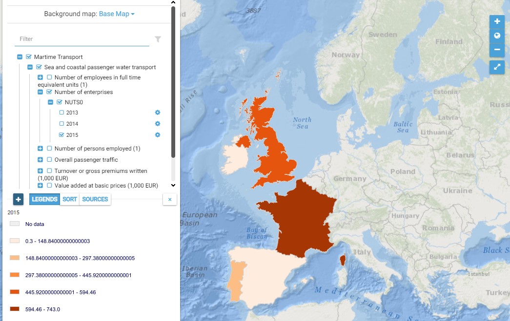
This map presents all layers corresponding to "Sea and coastal passenger water transport" activities in the Atlantic area. For more information about this NACE code : https://ec.europa.eu/eurostat/ramon/nomenclatures/index.cfm?TargetUrl=DSP_NOM_DTL_VIEW&StrNom=NACE_REV2&StrLanguageCode=EN&IntPcKey=18512804&IntKey=18512834&StrLayoutCode=HIERARCHIC&IntCurrentPage=1 Indicators collected are : Business indicators per country Number of persons employed and number of employees in full time equivalent units per NUTS 3 unit of the Atlantic Area Overall passenger traffic per main Atlantic port
-
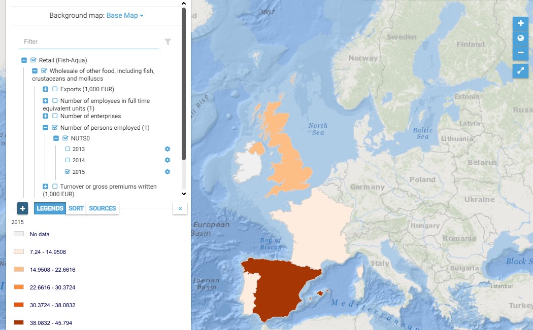
This map presents all layers corresponding to "Wholesale of other food, including fish, crustaceans and molluscs" activities in the Atlantic area. For more information about this NACE code : https://ec.europa.eu/eurostat/ramon/nomenclatures/index.cfm?TargetUrl=DSP_NOM_DTL_VIEW&StrNom=NACE_REV2&StrLanguageCode=EN&IntPcKey=18509714&IntKey=18509954&StrLayoutCode=HIERARCHIC&IntCurrentPage=1 Indicators collected are : Business indicators per country
-
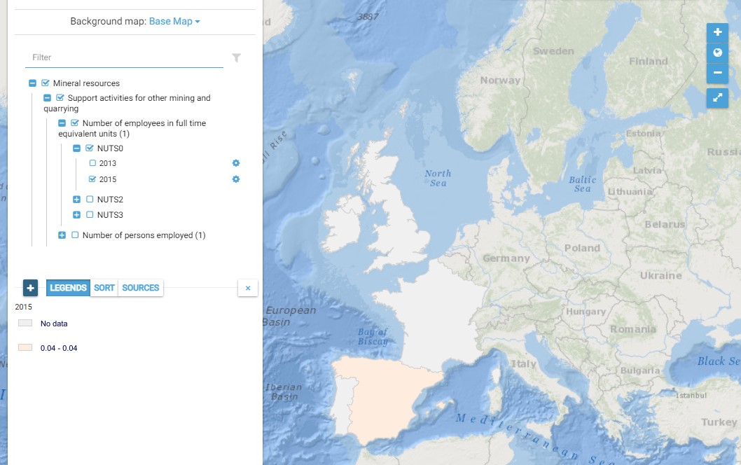
This map presents all layers corresponding to "Support activities for other mining and quarrying" activities in the Atlantic area. For more information about this NACE code : https://ec.europa.eu/eurostat/ramon/nomenclatures/index.cfm?TargetUrl=DSP_NOM_DTL_VIEW&StrNom=NACE_REV2&StrLanguageCode=EN&IntPcKey=18496274&IntKey=18496304&StrLayoutCode=HIERARCHIC&IntCurrentPage=1
-
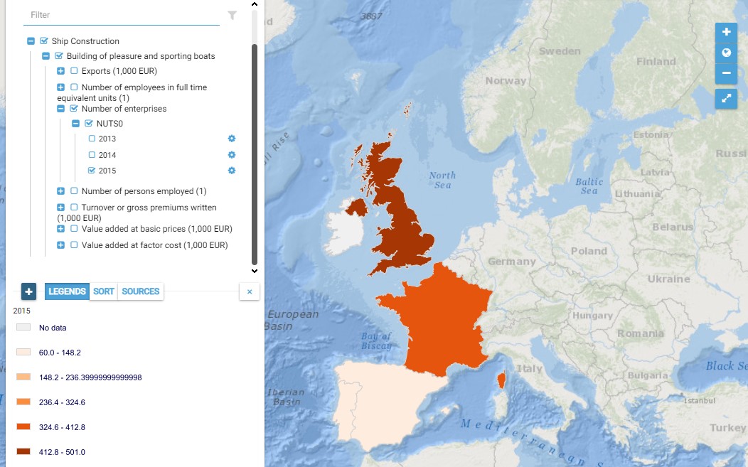
This map presents all layers corresponding to "Building of pleasure and sporting boats" activities in the Atlantic area. For more information about this NACE code : https://ec.europa.eu/eurostat/ramon/nomenclatures/index.cfm?TargetUrl=DSP_NOM_DTL_VIEW&StrNom=NACE_REV2&StrLanguageCode=EN&IntPcKey=18505424&IntKey=18505484&StrLayoutCode=HIERARCHIC&IntCurrentPage=1 Indicators collected are : Business indicators per country Number of persons employed and number of employees in full time equivalent units per NUTS 3 unit of the Atlantic Area
-
This map presents all layers corresponding to "Marine fishing" activities in the Atlantic area. For more information about this NACE code : https://ec.europa.eu/eurostat/ramon/nomenclatures/index.cfm?TargetUrl=DSP_NOM_DTL_VIEW&StrNom=NACE_REV2&StrLanguageCode=EN&IntPcKey=18508244&IntKey=18508274&StrLayoutCode=HIERARCHIC&IntCurrentPage=1 Indicators collected are : Business indicators per country
-
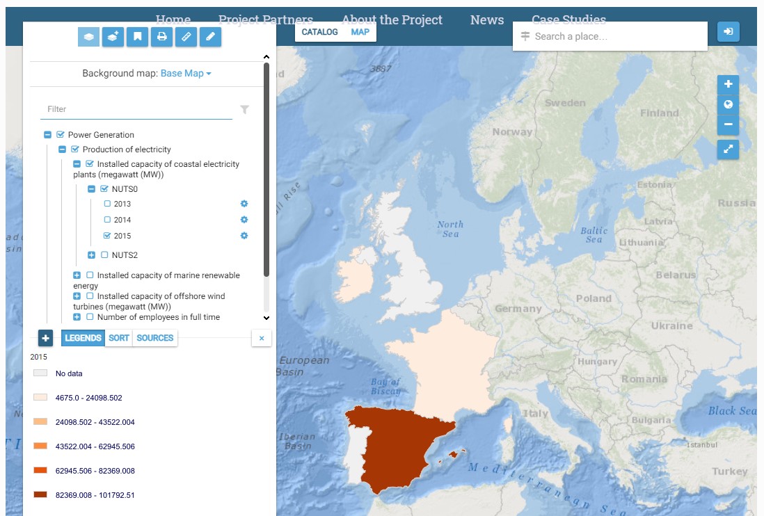
This map presents all layers corresponding to "Production of electricity" activities in the Atlantic area. For more information about this NACE code : https://ec.europa.eu/eurostat/ramon/nomenclatures/index.cfm?TargetUrl=DSP_NOM_DTL_VIEW&StrNom=NACE_REV2&StrLanguageCode=EN&IntPcKey=18506894&IntKey=18506924&StrLayoutCode=HIERARCHIC&IntCurrentPage=1 Indicators collected are : Nb of jobs in the Atlantic coastal zone per country Number of coastal power plants in the Atlantic zone overall Installed capacity of coastal electricity plants per Atlantic NUTS 2 Installed capacity of marine renewable energy per type of technology per Atlantic NUTS2 Installed capacity of offshore wind turbines per Atlantic NUTS2
-
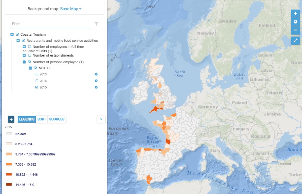
This map presents all layers corresponding to "Restaurants and mobile food service activities" activities in the Atlantic area. For more information about this NACE code : https://ec.europa.eu/eurostat/ramon/nomenclatures/index.cfm?TargetUrl=DSP_NOM_DTL_VIEW&StrNom=NACE_REV2&StrLanguageCode=EN&IntPcKey=18514004&IntKey=18514034&StrLayoutCode=HIERARCHIC&IntCurrentPage=1 Indicators collected are : Number of persons employed and number of employees in full time equivalent units per NUTS 3 unit of the Atlantic Area Number of establishments per NUTS3 unit of the Atlantic Area