 Metadata catalogue
map
Type of resources
Available actions
Topics
INSPIRE themes
Keywords
Contact for the resource
Provided by
Years
Formats
Representation types
Update frequencies
status
Scale
-
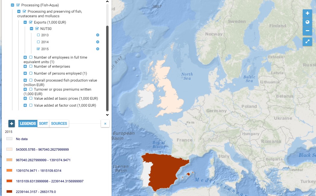
This map presents all layers corresponding to "Processing and preserving of fish, crustaceans and molluscs" activities in the Atlantic area. For more information about this NACE code : https://ec.europa.eu/eurostat/ramon/nomenclatures/index.cfm?TargetUrl=DSP_NOM_DTL_VIEW&StrNom=NACE_REV2&StrLanguageCode=EN&IntPcKey=18496514&IntKey=18496544&StrLayoutCode=HIERARCHIC&IntCurrentPage=1 Indicators collected are : Business indicators per country Total number of persons employed per Atlantic NUTS 3 unit Total production value in the Atlantic NUTS 3 units.
-
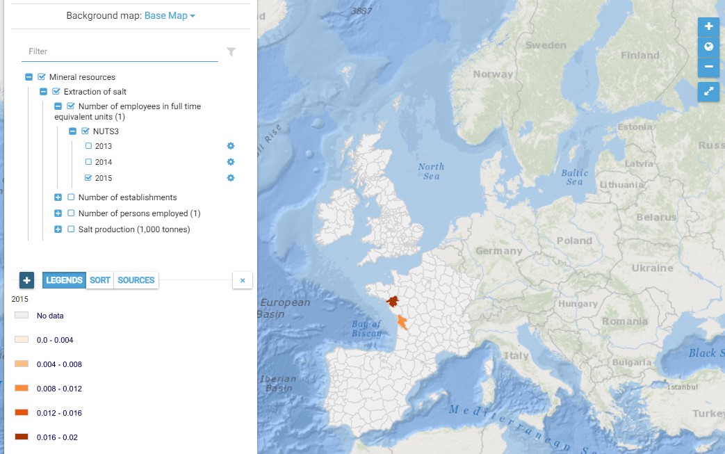
This map presents all layers corresponding to "Extraction of salt" activities in the Atlantic area. For more information about this NACE code : https://ec.europa.eu/eurostat/ramon/nomenclatures/index.cfm?TargetUrl=DSP_NOM_DTL_VIEW&StrNom=NACE_REV2&StrLanguageCode=EN&IntPcKey=18496034&IntKey=18496124&StrLayoutCode=HIERARCHIC&IntCurrentPage=1 Indicators collected are : Number of persons employed and number of employees in full time equivalent units per NUTS 3 unit of the Atlantic Area Salt production per Atlantic NUTS3
-
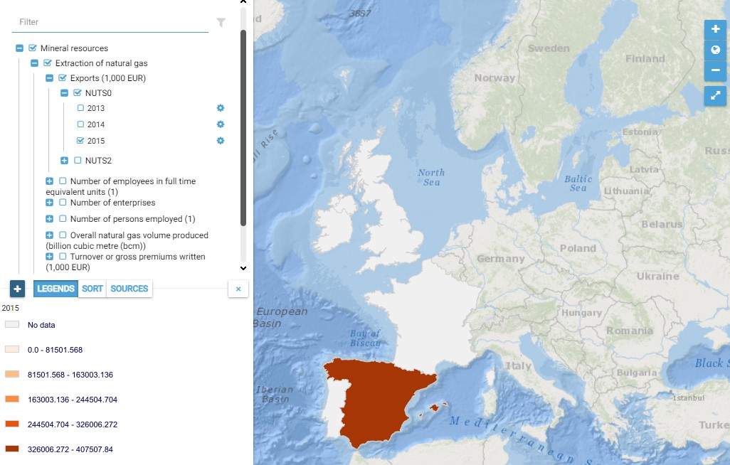
This map presents all layers corresponding to "Marine fishing" activities in the Atlantic area. For more information about this NACE code : https://ec.europa.eu/eurostat/ramon/nomenclatures/index.cfm?TargetUrl=DSP_NOM_DTL_VIEW&StrNom=NACE_REV2&StrLanguageCode=EN&IntPcKey=18495674&IntKey=18495704&StrLayoutCode=HIERARCHIC&IntCurrentPage=1 Indicators collected are : Business indicators per country Number of persons employed on Atlantic pits and rigs Overall gas volume produced Overall volume produced from Atlantic gas terminals
-
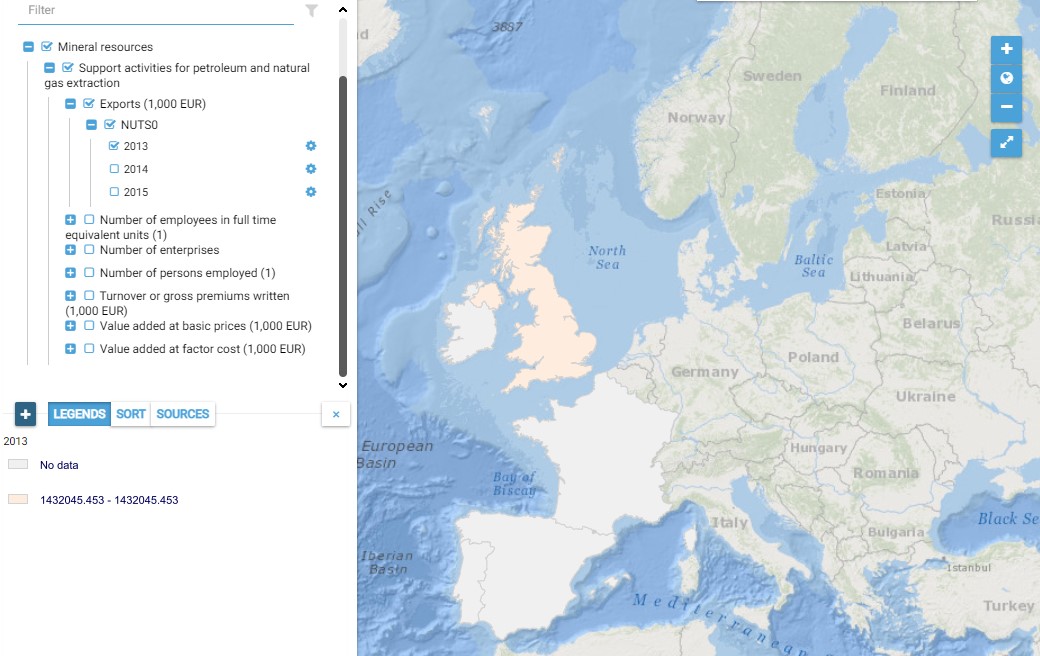
This map presents all layers corresponding to "Support activities for petroleum and natural gas extraction" activities in the Atlantic area. For more information about this NACE code : https://ec.europa.eu/eurostat/ramon/nomenclatures/index.cfm?TargetUrl=DSP_NOM_DTL_VIEW&StrNom=NACE_REV2&StrLanguageCode=EN&IntPcKey=18496214&IntKey=18496244&StrLayoutCode=HIERARCHIC&IntCurrentPage=1 Indicators collected are : Total number of persons employed on Atlantic pits and rigs
-
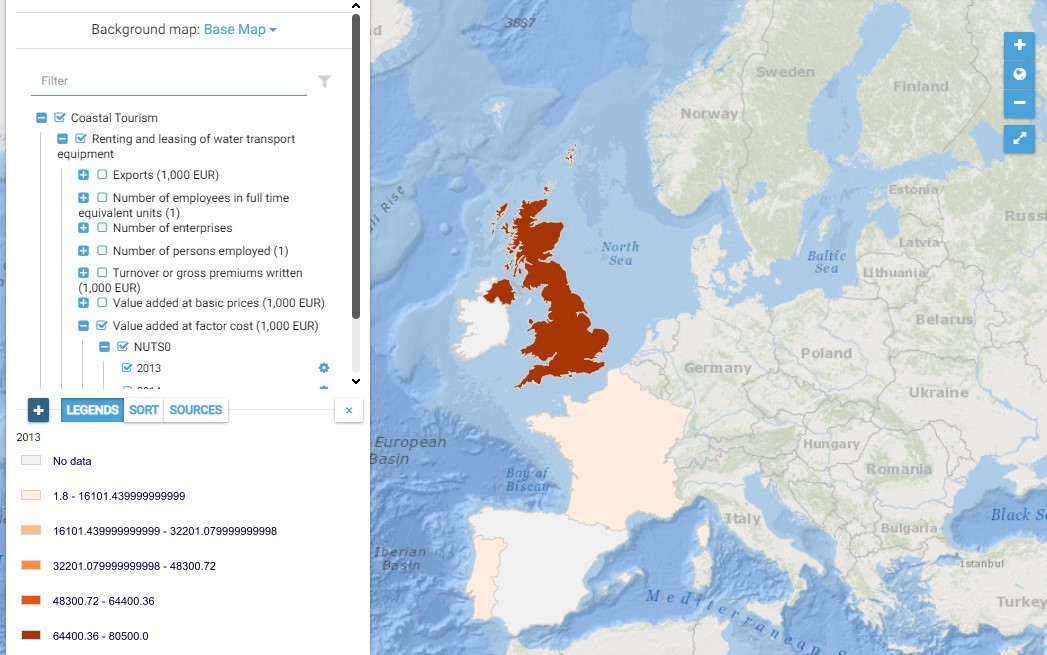
This map presents all layers corresponding to "Renting and leasing of water transport equipment" activities in the Atlantic area. For more information about this NACE code : https://ec.europa.eu/eurostat/ramon/nomenclatures/index.cfm?TargetUrl=DSP_NOM_DTL_VIEW&StrNom=NACE_REV2&StrLanguageCode=EN&IntPcKey=18518354&IntKey=18518474&StrLayoutCode=HIERARCHIC&IntCurrentPage=1 Indicators collected are : Business indicators per country Number of persons employed and number of employees in full time equivalent units per NUTS 3 unit of the Atlantic Area
-
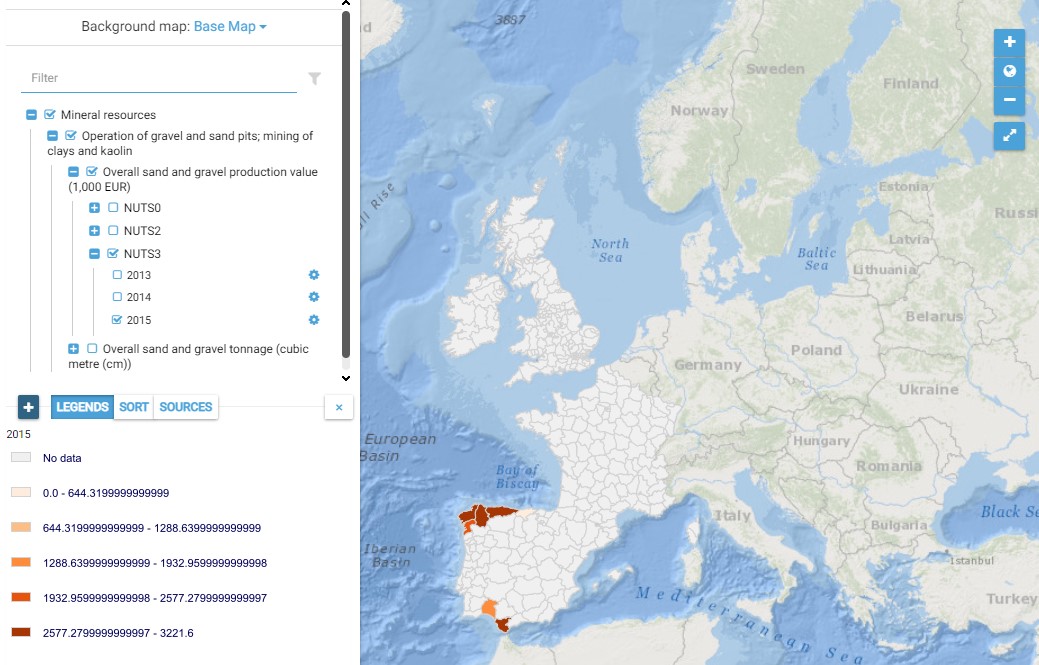
This map presents all layers corresponding to "Operation of gravel and sand pits" activities in the Atlantic area. For more information about this NACE code : https://ec.europa.eu/eurostat/ramon/nomenclatures/index.cfm?TargetUrl=DSP_NOM_DTL_VIEW&StrNom=NACE_REV2&StrLanguageCode=FR&IntPcKey=18495944&IntKey=18496004&StrLayoutCode=HIERARCHIC&IntCurrentPage=1 Indicators collected are : - Total number of jobs for Atlantic dredge areas - Overall production value from Atlantic dredge areas - Overall tonnage from Atlantic dredge areas
-
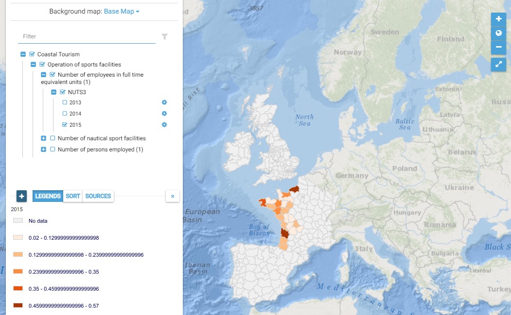
This map presents all layers corresponding to "Operation of sports facilities" activities in the Atlantic area. For more information about this NACE code : https://ec.europa.eu/eurostat/ramon/nomenclatures/index.cfm?TargetUrl=DSP_NOM_DTL_VIEW&StrNom=NACE_REV2&StrLanguageCode=EN&IntPcKey=18522104&IntKey=18522134&StrLayoutCode=HIERARCHIC&IntCurrentPage=1 Indicators collected are : - Number of persons employed and number of employees in full time equivalent units per NUTS 3 unit of the Atlantic Area - Number of nautical sport facilities per NUTS3 unit of the Atlantic Area
-
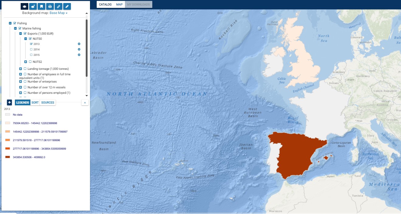
This map presents all layers corresponding to "Marine fishing" activities in the Atlantic area. For more information about this NACE code : https://ec.europa.eu/eurostat/ramon/nomenclatures/index.cfm?TargetUrl=DSP_NOM_DTL_VIEW&StrNom=NACE_REV2&StrLanguageCode=FR&IntPcKey=18495224&IntKey=18495254&StrLayoutCode=HIERARCHIC&IntCurrentPage=1 Indicators collected are : - Business indicators per country - Number of persons employed and number of employees in full time equivalent units per NUTS 3 unit of the Atlantic Area - Landing tonnage per Atlantic NUTS3 - Number of over 12 metre vessels per Atlantic NUTS3
-
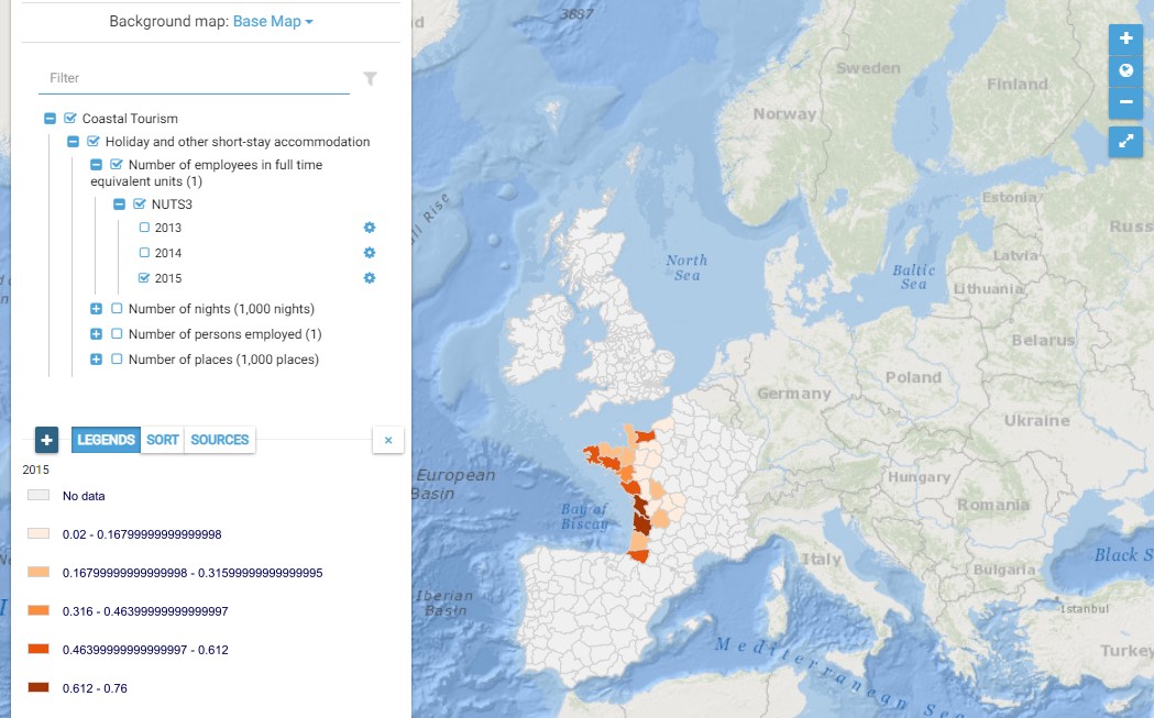
This map presents all layers corresponding to "Holiday and other short-stay accommodation" activities in the Atlantic area. For more information about this NACE code : https://ec.europa.eu/eurostat/ramon/nomenclatures/index.cfm?TargetUrl=DSP_NOM_DTL_VIEW&StrNom=NACE_REV2&StrLanguageCode=EN&IntPcKey=18513794&IntKey=18513824&StrLayoutCode=HIERARCHIC&IntCurrentPage=1 Indicators collected are : Number of places per NUTS 3 unit of the Atlantic Area
-
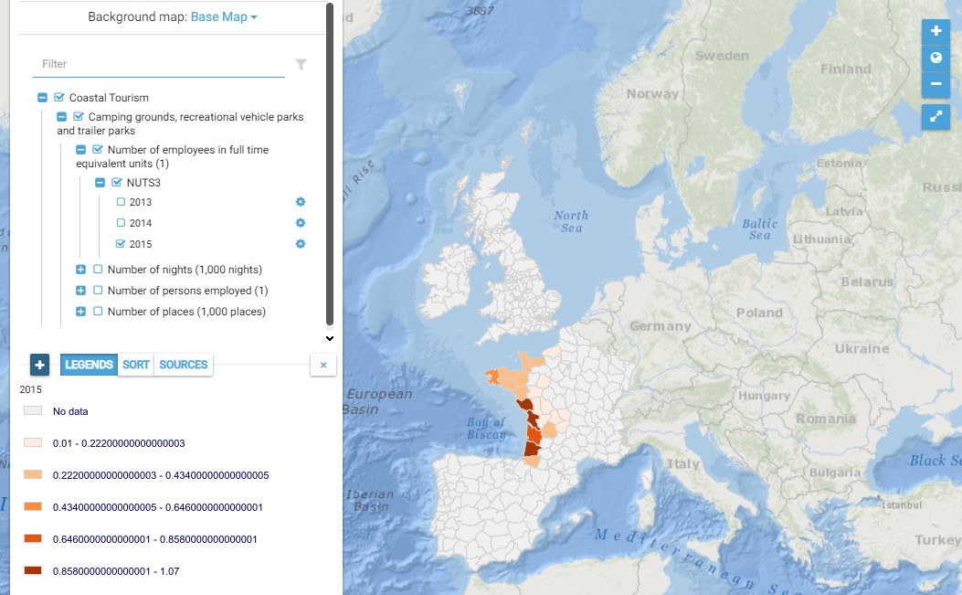
This map presents all layers corresponding to "Camping grounds, recreational vehicle parks and trailer parks" activities in the Atlantic area. For more information about this NACE code : https://ec.europa.eu/eurostat/ramon/nomenclatures/index.cfm?TargetUrl=DSP_NOM_DTL_VIEW&StrNom=NACE_REV2&StrLanguageCode=EN&IntPcKey=18513734&IntKey=18513764&StrLayoutCode=HIERARCHIC&IntCurrentPage=1 Indicators collected are : Number of places per NUTS 3 unit of the Atlantic Area