 Metadata catalogue
transportation
Type of resources
Available actions
Topics
INSPIRE themes
Keywords
Contact for the resource
Provided by
Years
Formats
Representation types
Update frequencies
status
Scale
Resolution
-
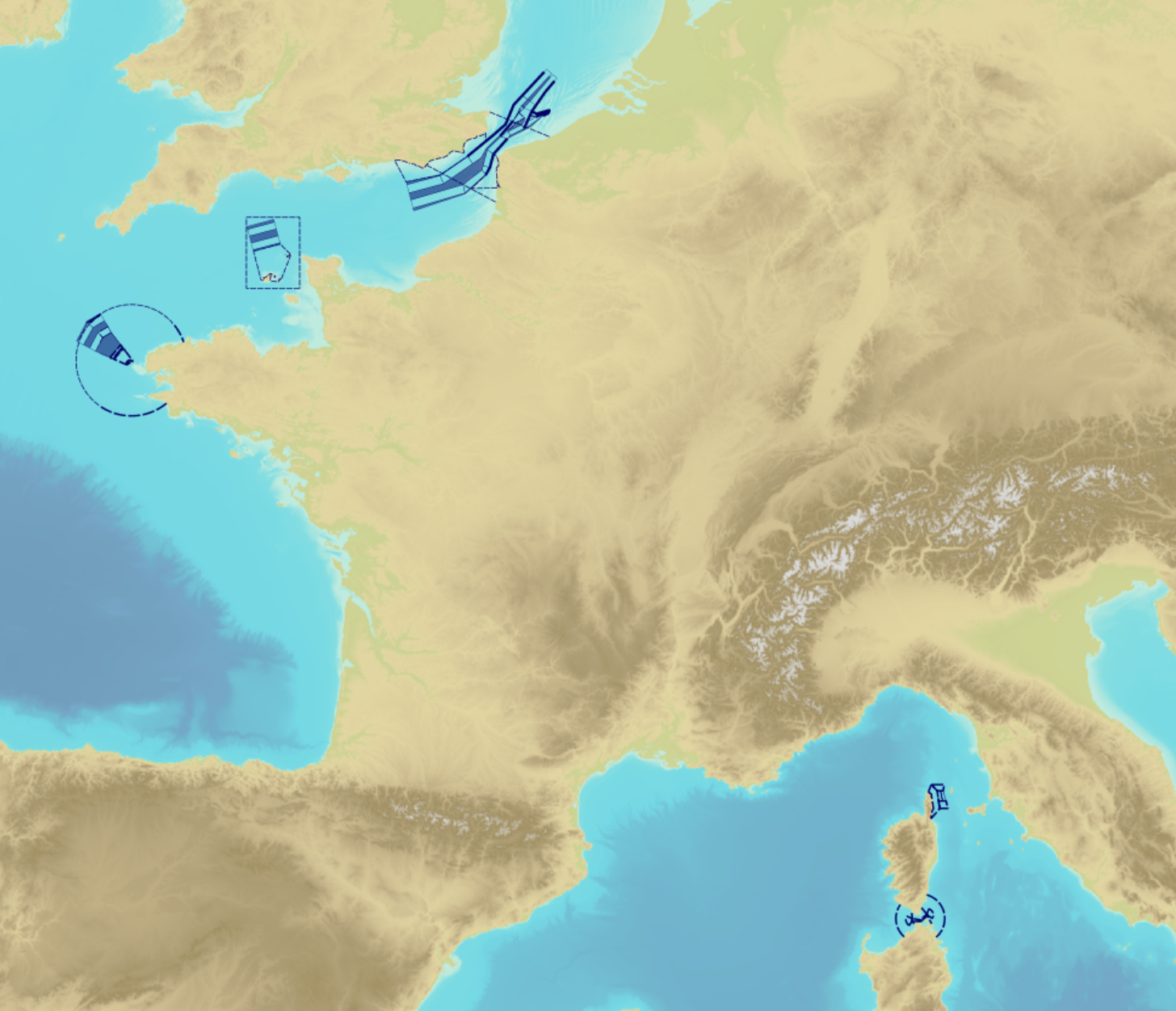
"Traffic Separation Schemes" product contains a description of TSS in French maritime spaces. A TSS is a routeing measure aimed at the separation of opposing streams of traffic by appropriate means and notably by the establishment of traffic lanes. The measures taken aim at improving navigation safety in areas where navigation is threatened by the density of traffic associated with various natural difficulties. Several classes of objects constitute this product, the acronyms used are those of IHO standard S-57: - Traffic separation scheme lane part (TSSLPT): area of a traffic lane in which the direction of flow of traffic is uniform; - Traffic separation scheme boundary (TSSBND): outer limit of a traffic lane part or a traffic separation scheme roundabout; - Traffic separation line (TSELNE): common boundary between two traffic lanes, or between one traffic lane and one inshore traffic zone; - Traffic separation zone (TSEZNE): separation areas between two traffic lanes, or between one traffic lane and one inshore traffic zone, or to the central area of a roundabout; - Inshore traffic zone (ISTZNE): area between the landward boundary of a traffic separation scheme and the adjacent coast; - Precautionary area (PRCARE): area, within defined limits, where ships must navigate with particular caution, and within which the direction of traffic flow may be recommended; - Deep water route part (DWRTPT): sections within which the flow of traffic either follows one defined direction for one-way traffic, or follows one defined direction and its reciprocal for two-way traffic. A deep-water route is a route in a designated area within defined limits which has been accurately surveyed for clearance of sea bottom and submerged obstacles to a minimum indicated depth of water; - Two-way route part (TWRTPT): sections within which traffic flows in two directions along one bearing and its reciprocal. These route parts are generally two-way, but some may be restricted to one-way traffic flow; - Radio calling-in line (RDOCAL_lne) : positions at which vessels are required to report to a traffic control centre.
-
Dataset showing the location of the tram line in Edinburgh
-
Polygons of all the parking bays within the City Of Edinburgh Council administrative area backed by a Traffic Regulation Order (TRO).
-
Point data set depicting all of the bridges on the Scottish Canal Network. Including accommodation, public road, foot, swing, pipe/cable and railway bridges and bridge abutments.
-

Marina Areas correspond to the vector delimitation, using photointerpretation, the area occupied by the port infrastructure. The vectorization was based on the orthophotomaps produced by the Regional Secretariat for Science, Technology and Equipment, at 1:5000 scale to the islands of the eastern and central groups and orthoimagery obtained from satellite images on the same scale to the western group. They served to support the vectorization of the ports areas delimitations included in the Integrated Coastal Marine Management plan (POOC).
-

-
This dataset represents passenger and vehicle ferry ports in Scotland. These are the start and end terminals for the Scottish Ferry Routes dataset. It was initially created for use within the development of the Scottish Government's Urban Rural Classification. Ports which service both subsidised and private active ferry routes are included. Ferry ports and attributes are based upon route information obtained from Traveline data aggregated from operators (e.g. Caledonian MacBrayne, NorthLink Ferries, etc.).
-
Point dataset showing the position of winding holes and other recommended turning points along the navigational network. Captured from OS MasterMap.
-
HERs (Historic Environment Records) developed out of SMRs (Sites and Monuments Records). SMRs were established from the 1960s onwards in response to the loss of the archaeological resource through urban and rural development. From their original remit of recording archaeological sites, they have been developed to encompass a wide range of information about the historic environment which has been reflected in the change of name from SMR to HER. Today they provide a unique information resource, forming the basis for sustainable conservation and playing an important role in informing public understanding and enjoyment of the local historic environment. The historic environment includes all aspects of our surroundings that have been built, formed or influenced by human activities from earliest to most recent times. A Historic Environment Record stores and provides access to systematically organised information about these surroundings in a given area. It is maintained and updated for public benefit in accordance with national and international standards and guidance. An HER makes information accessible to all in order to: - advance knowledge and understanding of the historic environment; - inform its care and conservation; - inform public policies and decision-making on land-use planning and management; - contribute to environmental improvement and economic regeneration; - contribute to education and social inclusion; - encourage participation in the exploration, appreciation and enjoyment of the historic environment. Local authorities and most National Park authorities maintain records of the archaeological, built and natural environment. However, many services group together to form archaeological services to collate their standardised records. Specialist staff are employed to curate these records and also to provide specialist advice for land-use planning and public information services. This dataset has two distinct data layers: - Historic Environment Sites (including Known Site Extents and Areas of Archaeological Interest) - a polygon dataset - Historic Environment Events (also known as interventions) - a polygon dataset. Where only points or lines have been provided these have been buffered by 10m to create representative polygons.
-
A point dataset depicting the location of locks on Scottish Canal’s network.