 Metadata catalogue
200000
Type of resources
Available actions
Topics
INSPIRE themes
Keywords
Contact for the resource
Provided by
Years
Formats
Representation types
Update frequencies
status
Scale
Resolution
-
Inventory of faults and tectonic boundaries in Brandenburg at regional scale (approx. 1:200.000 - 1:1.000.000)
-
Map showing Licensing Position of Ukraine 1:200 000
-
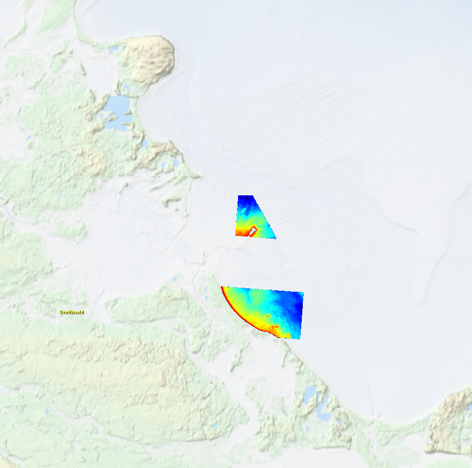
High resolution composite DTM based on multi beam surveys in German Bodden waters. All data acquired in 2016.
-
Soil-type map of Denmark 1:200.000 version 2. An interpreted overview map of surface geology in Denmark. The map shows a countrywide classification and distribution of soil types (mostly glacial and postglacial sediments) at the surface of Denmark. The soil types are divided into 12 different legend items. The map has a scale of 1:200.000, and is suited for educational use and as a background layer for other mapped themes. The map is published in GEUS report 2011/19.
-
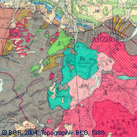
The map series General Geological Map of the Federal Republic of Germany 1:200,000 (GÜK200) is the result of cooperation between the State Geological Surveys of the Federal Republic of Germany (SGD), the Geological Surveys of neighbouring countries and the Federal Institute for Geosciences and Natural Resources (BGR). The GÜK200 displays the surface geology of Germany and adjacent areas of neighbouring countries on 55 map sheets. The map sheets show the regional dissemination of more than 3800 geological units. The geological units contain information on stratigraphy (age), genesis and petrography (composition) of the rocks. Each printed/scanned map sheet contains one or several geological cross-sections which give an insight into the subsurface. The digital data of the map series are stored separately for each map sheet. According to this geological units/polygons, their boundaries, tectonic linear elements and, if present, ice sheet boundaries are saved as a discrete layer in a shapefile for the single map sheets. The attributes of the geological units contain information – like in the printed map sheets – on stratigraphy, genesis and petrography of the rocks.
-
-
-
-
Geographical distribution of three nuclear clusters (Q1, Q2, Q3) inferred by a Bayesian clustering analysis (STRUCTURE) after evaluating genetic diversity at nine nuSSR over 217 Jacaranda copaia in five regions in the Neotropics (Western Amazonia, Southern Amazonia, Central Amazonia, Guiana Shield, Central America). For more details, see Scotti-Saintagne et al., 2013 Journal of biogeography vol 40 pp 707-719. This work was funded by the EU-funded INCO “SEEDSOURCE” project, by the EU-funded PO-FEDER “ENERGIRAVI” program and the ANR funded Programme “BRIDGE”
-

3 mosaics of 5 map sheets: 1. Carte des fonds du plateau continental sénégalo-mauritanien : de Dakar à 17° Nord. Scale of 1:300 000. Date of publication: 1976. 2. Carte des fonds du plateau continental sénégambien : de 12° Nord à Dakar. Scale of 1:300 000. Date of publication: 1975. 3. Carte sédimentologique du plateau continental sénégambien (extension à une partie du plateau continental de la Mauritanie et de la Guinée Bissau) : Dakar. Scale of 1:1 000 000 to 1:200 000. Date of publication: 1977. 4. Carte sédimentologique du plateau continental sénégambien (extension à une partie du plateau continental de la Mauritanie et de la Guinée Bissau) : Oussouye. Scale of 1:1 000 000 to 1:200 000. Date of publication: 1977. 5. Carte sédimentologique du plateau continental sénégambien (extension à une partie du plateau continental de la Mauritanie et de la Guinée Bissau) : Saint-Louis. Scale of 1:1 000 000 to 1:200 000. Date of publication: 1977.