 Metadata catalogue
utilitiesCommunication
Type of resources
Available actions
Topics
INSPIRE themes
Keywords
Contact for the resource
Provided by
Years
Formats
Representation types
Update frequencies
status
Scale
Resolution
-

High Voltage 33kV Overhead Line. While all reasonable steps have been taken to ensure the accuracy, completeness and reliability of the information provided, Enemalta assumes no responsibility for any errors, inaccuracies or missing information. In no event shall Enemalta be liable for any direct, indirect, special or incidental damage resulting from, arising out of or in connection with the use of the information being provided.
-
The product contains a description of submarine cables and pipelines brought to the attention of Shom on French areas of responsibility. These are 2D linear objects of the seabed that divide into two categories: • The submarine cables: these are cables placed on the seabed where electricity or information (telecommunication) flows. They represent the vast majority of objects (more than 90%); • Emissaries and submarine pipes: these are pipes that allow the discharge, sampling or circulation of fluids.
-
Water Supply Zones represent the extend of the area supplied by Scotland's water authority (Scottish Water). These zones represent the extent of the drinking water supply in a given area. The dataset is created new for each calendar year and remains fixed until the next year. The year is also known as the Reporting Year. Each water supply zone must not have a total population greater than 100,000. The water authority must also supply the full name, a unique reference number and a population supplied for each zone.
-

Transformer Centre. While all reasonable steps have been taken to ensure the accuracy, completeness and reliability of the information provided, Enemalta assumes no responsibility for any errors, inaccuracies or missing information. In no event shall Enemalta be liable for any direct, indirect, special or incidental damage resulting from, arising out of or in connection with the use of the information being provided.
-
Representação geográfica dos Equipamentos do Município de Nordeste. Os dados estão em conformidade com as especificações técnicas do Anexo III.6 Utility and Government Services da Diretiva INSPIRE.
-

Medium Voltage 11kV Overhead Line. While all reasonable steps have been taken to ensure the accuracy, completeness and reliability of the information provided, Enemalta assumes no responsibility for any errors, inaccuracies or missing information. In no event shall Enemalta be liable for any direct, indirect, special or incidental damage resulting from, arising out of or in connection with the use of the information being provided.
-
SGN create 4 separate data layers (by pressure tier) to depict the location of their gas network: LP - Low Pressure (19 mbar - 75 mbar) MP - Medium Pressure (75mbar - 2 bar) IP - Intermediate Pressure (2 bar - 7 bar) HP - Regional High Pressure (>7 bar) The gas network data is up to date at the time of publication, but it is given without warranty as to the accuracy of the information shown. Service pipes, valves, siphons, sub-connections etc. are not shown but their presence should be anticipated. No liability of any kind whatsoever is accepted by SGN or its agents, servants or sub-contractors for any error or omission. Should the user wish to excavate in the vicinity of pipelines, the User should visit SGN via sgn.co.uk/Safety/Dig-safely for further information. SGN use an on-line mapping system, accessible via the sgn.co.uk/Safety/Dig-safely web pages or linesearchbeforeudig.co.uk, this process should be used to obtain up to date maps and safety information before you excavate. However if you need more information please contact our Safety Admin team on 0800 912 1722 or by email: plantlocation@sgn.co.uk. For the avoidance of doubt, safe digging practices, in accordance with HS (G) 47, must be used to verify and establish the actual position of mains, pipes, services and other apparatus on site before any mechanical plant is used. It is your responsibility to ensure that this information is provided to all persons (whether direct labour or contractors) working for you on or near gas apparatus. Mains shown in the data are those owned by SGN by virtue of being a licensed Gas Transporter (GT). Gas pipes owned by other GT’s, or third parties, may also be present in the area and are not shown in the data. Information with regard to such pipes should be obtained from the relevant owners
-
The geodatabase on aggregate extractions in the EU was created in 2014 by AZTI-Tecnalia for the European Marine Observation and Data Network (EMODnet). It is the result of the aggregation and harmonization of datasets provided by several sources from all across the EU. It is available for viewing and download on EMODnet - Human Activities web portal (www.emodnet-humanactivities.eu). The database contains points representing aggregate extraction sites, by year (although some data are indicated by a period of years), in the following countries: Belgium, Denmark, Finland, France, Germany, Ireland, Italy, Poland, Spain, Sweden, The Netherlands and United Kingdom. Where available, each point has the following attributes: Id (Identifier), Position Info (e.g.: Estimated, Original, Polygon centroid of dredging area, Estimated polygon centroid of dredging area), Country, Sea basin, Name of the extraction area, Area of activity (km2), Year (the year when the extraction took place), Permitted Amount (m3) (permitted amount of material to be extracted, in m3), Permitted Amount (t) (permitted amount of material to be extracted, in tonnes), Requested Amount (m3) (requested amount of material to be extracted, in m3), Requested Amount (t) (requested amount of material to be extracted, in tonnes), Extracted Amount (m3) (extracted amount of material, in m3), Extracted Amount (t) (extracted amount of material, in tonnes), Extraction Type (Marine sediment extraction), Purpose (e.g.: Commercial, Others, N/A), End Use (e.g.: Beach nourishment, Construction, Reclamation fill, N/A), Material type (e.g.: sand, gravel, maerl), Notes, Link to Web Sources.
-
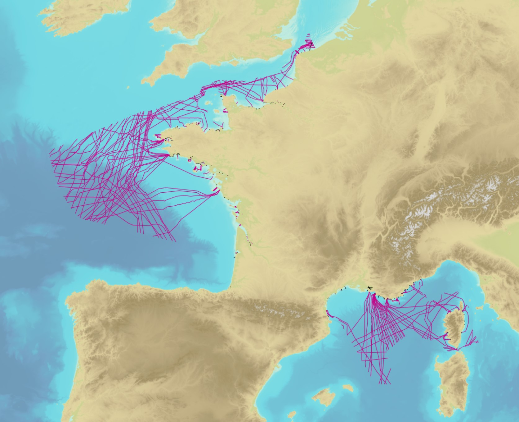
Abstract from http://www.emodnet-humanactivities.eu/search-results.php?dataname=Telecommunication+Cables+%28schematic+routes%29 The dataset on submarine telecom cables was created by Cogea in 2014 for the European Marine Observation and Data Network. The underlying data is property of Telegeography and is available online at https://github.com/telegeography/www.submarinecablemap.com. Compared with the previous version, this version of includes the gigabit per second values that come from the Cable System Database of the Packet Clearing House organization and are available online at https://prefix.pch.net/applications/cablesystem/. The database contains lines and points representing cables and related landing points. Cables are represented as stylised paths, as actual cable routes locations are not available in most cases. The dataset includes any cable that crosses the EU waters (Marine regions). Marine regions and subregions boudaries are defined in Article 4 of the Marine Strategy Framework Directive (MSFD) and available online at https://www.eea.europa.eu/data-and-maps/data/msfd-regions-and-subregions. Citation Title EMODnet Human Activities: Telecom cables (schematic routes) Publication date 2014-08-24 Revision date 2016-07-07 Creation date 2014-07-31
-

Low Voltage Transformer. While all reasonable steps have been taken to ensure the accuracy, completeness and reliability of the information provided, Enemalta assumes no responsibility for any errors, inaccuracies or missing information. In no event shall Enemalta be liable for any direct, indirect, special or incidental damage resulting from, arising out of or in connection with the use of the information being provided.