 Metadata catalogue
TIFF
Type of resources
Available actions
Topics
INSPIRE themes
Keywords
Contact for the resource
Provided by
Years
Formats
Representation types
Update frequencies
status
Service types
Scale
Resolution
-
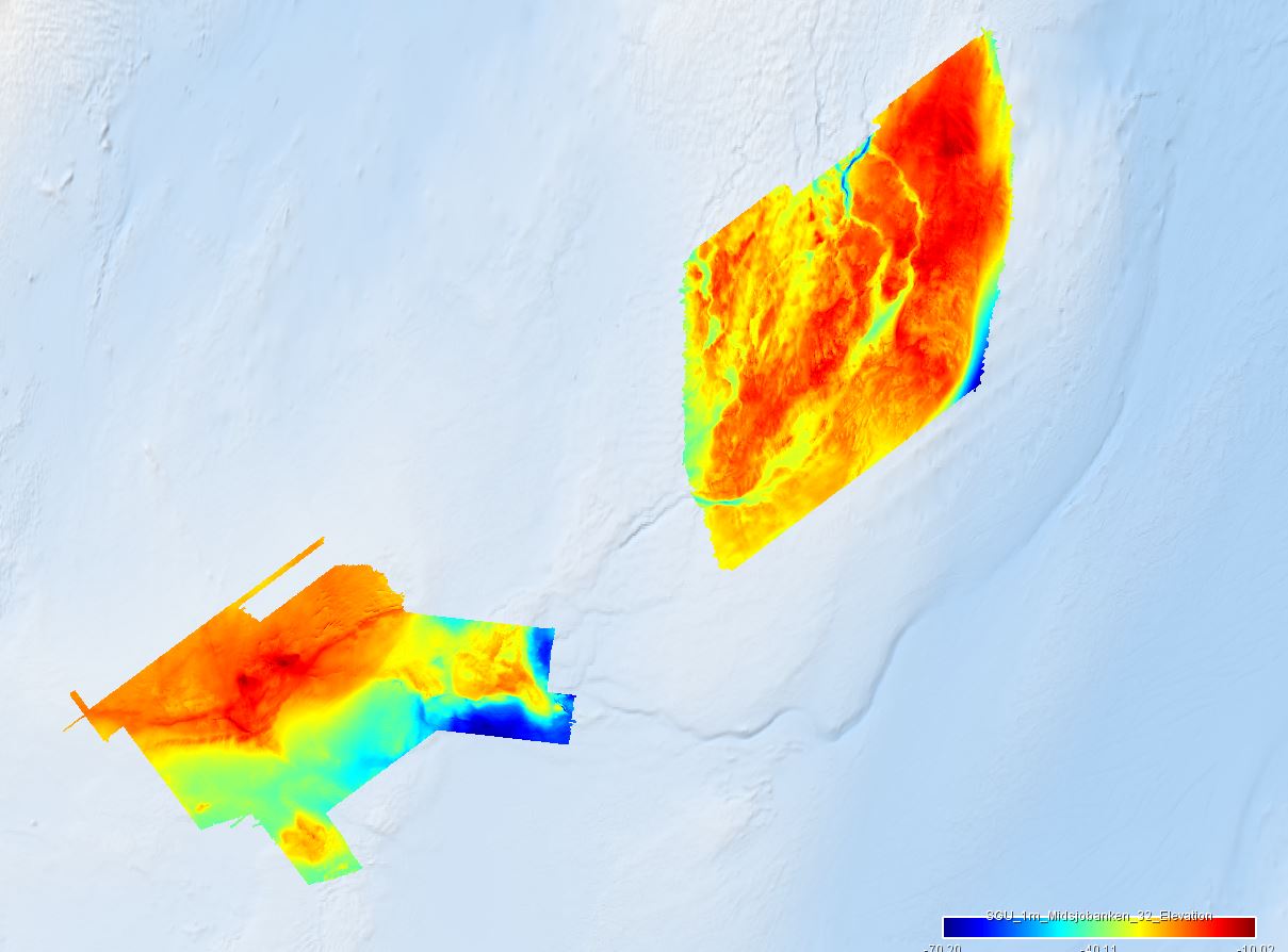
The dataset covers the areas of Northern Midsea bank (Norra Midsjöbanken) and Hoburgs bank in the Baltic Sea Region. The areas were surveyed using multibeam sonar, and collected sediment samples and high-resolution underwater images. For the EMODnet project, the data was delivered in TIFF-format and with a resolution of 1 meter for Northern Midsea and 10 meter for Hoburgs bank.
-
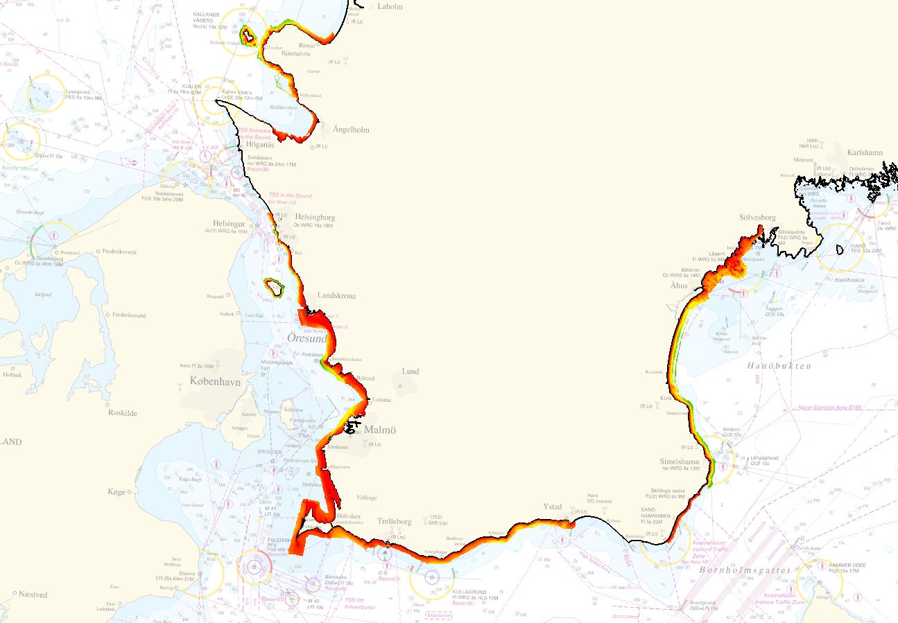
The dataset is provided by Geological Survey of Sweden (SGU) for EMODnet Bathymetry 2022. The dataset covers the areas of Skåne strand, in the Baltic Sea Region. The area was surveyed using LiDAR and multibeam sonar and merged into one composite grid. For the EMODnet project, the data was delivered in a resolution of 1 meter.
-
Data extracted from the Norwegian bathymetric database. The data has several sources and has been exported in 50 and 25 meter resolution.
-
Black and white seafloor photomosaic of the Lucky Strike hydrothermal field and the ridge axis to the South, acquired with VICTOR6000 during the Bathyluck 2009. Individual still images were matched, corrected for uneven illumination, renavigated and blended for a seamless photomosaic. This data release includes partial geotiffs covering the whole surveyed area. To be cited: Gini et al. (submitted); Barreyre et al. (2012); Escartin et al. (2013); Escartín et al. (2015).
-
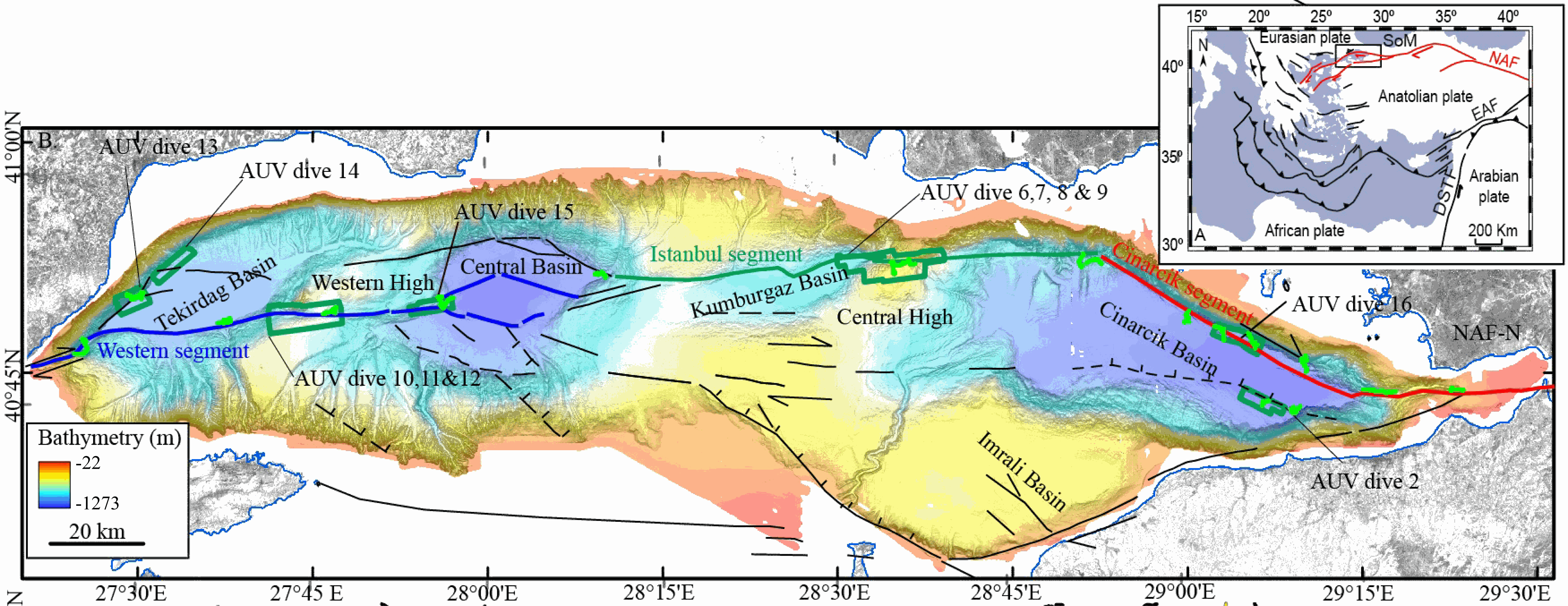
This data set contains processed multibeam sounder data from 12 dives of AsterX AUV performed on active faults scarps of the North Anatolian Fault system in the Sea of Marmara during the Marmesonet cruise (2009). The AUV carried a SIMRAD EM2000 multibeam echosounder, operating at 200 kHz, and surveyed at 50 to 70 m altitude, allowing a swath width of 150-200 m. Digital Elevation Models (DEM, in meters below sealevel) and seafloor backscatter intensity mosaics (relative amplitude in dB) are provided for 7 zones: Tekirdağ Basin W (dive 13), Tekirdağ Basin NW (dive 14), Western High (dives 10, 11 and 12), Western High E (dive 15), Central High (dive 6,7,8 and 9), Çınarcık Basin N (dive 16), Çınarcık Basin S (dive 2) (see figure). The horizontal resolution and grid pixel size of the DEM is 2 m. That of the backscatter intensity image is 1 m. Two versions of the DEM are provided. Version 1 is consistent with the backscatter image. Version 2 was updated applying a Fofonoff correction to the depths and relocating part of the AUV multibeam sounding points to fit EM302 shipborne multibeam maps. Version 2 depths and absolute positions are more accurate (10 m in the WGS-84 reference frame), but Version 1 will give better results if the backscatter image is applied as a texture or shading on the DEM. DEM and Backscatter raster files are provided in GeoTIFF format (readable with ArcGis 10.3 and QGIS 3) and use projected cartesian coordinates. They were converted from CARAIBES (Ifremer bathymetry and imagery processing software) output raster files with QGIS using GDAL translator. The Coordinate Reference System is a world Mercator projection based on WGS-84 datum, using meter units and a standard parallel at N40° latitude (latitude of preserved scale) {proj4: +proj=merc +lon_0=0 +lat_ts=+40 +x_0=0 +y_0=0 +datum=WGS84 +units=m +no_defs}. For GIS skeptics, one possible way to use these grids with Generic Mapping Tools is to perform a reverse projection back to geographic coordinates. Assuming the default PROJ_ELLIPSOID is properly set to WGS-84, the reverse projection can be applied (using gmt version 5) with the following command line: gmt grdproject AUV_XXX.tif=gd -GAUV_XXX.grd -Jm0/40/1:1 -F -C -I -V
-
As fotografias foram obtidas em sete missões executadas entre o dia 10 de Fevereiro e do dia 4 de Março de 2004, pela Municípia, S.A.. O voo foi feito à escala 1:8 000 abaixo da cota 600.
-
As fotografias foram obtidas em sete missões executadas entre o dia 10 de Fevereiro e do dia 4 de Março de 2004, pela Municípia, S.A.. O voo foi feito à escala 1:18 000 acima da cota 600.
-
Carta do Regime de Uso do Solo - Alcácer do Sal (Web Map Service). Informação extraída das plantas de ordenamento (escala 1:50.000) do PDM em vigor com aplicação da classificação e qualificação do solo estabelecida no DR 11/2009 de 29 de Maio.
-
Carta do Regime de Uso do Solo - Albufeira (Web Map Service). Informação extraída das plantas de ordenamento (escala 1:25.000) do PDM em vigor com aplicação da classificação e qualificação do solo estabelecida no DR 11/2009 de 29 de Maio.
-
Carta do Regime de Uso do Solo - Almodôvar (Web Map Service). Informação extraída das plantas de ordenamento (escala 1:25.000) do PDM em vigor com aplicação da classificação e qualificação do solo estabelecida no DR 11/2009 de 29 de Maio.