 Metadata catalogue
view
Type of resources
Available actions
INSPIRE themes
Keywords
Contact for the resource
Provided by
Years
Formats
Update frequencies
status
Service types
-
The web services are developed under the eENVplus project, to provide download service compliant with GeoSciML INSPIRE Data model and to perform pilot demostration.
-
Product by the Pangeo project: http://www.pangeoproject.eu/ PanGeo provides information about the stability of the ground on which we live, work and play. Ground instability, or "geohazards", affect us all. They can be dangerous and costly, yet information on these phenomena can be difficult if not impossible to obtain. The PanGeo service provides entirely free access to geohazard information for many of the largest cities in Europe . The PanGeo service is aimed at local authorities, civil protection agencies, geological surveys, the public, insurers and businesses providing environmental and land reporting services. The service and products available are entirely free to use, even for commercial gain, providing appropriate credits are given (see licence terms). Information in PanGeo is derived from detailed analysis of local geological data combined with satellite measurements of ground movement.
-
Data from the British Geological Survey's GeoIndex Map products theme are made available for viewing here. GeoIndex is a website that allows users to search for information about BGS data collections covering the UK and other areas world wide. Access is free, the interface is easy to use, and it has been developed to enable users to check coverage of different types of data and find out some background information about the data. More detailed information can be obtained by further enquiry via the web site: www.bgs.ac.uk/geoindex.
-
The hydrogeological map indicates aquifer potential in generalised terms using a threefold division of geological formations: those in which intergranular flow in the saturated zone is dominant, those in which flow is controlled by fissures or discontinuities and less permeable formations including aquifers concealed at depth beneath covering layers. Highly productive aquifers are distinguished from those that are only of local importance or have no significant groundwater. Within each of these classes the strata are grouped together according to age or lithology. The 1:625 000 scale data may be used as a guide to the aquifers at a regional or national level, but should not be relied on for local information.
-
BGS offshore marine products are made available to view via this web map service. The 1:250 000 scale offshore geological maps in the UTM series (Universal Transverse Mercator projection) are available digitally as two themes: bedrock geology (DigRock250) and sea-bed sediments (DigSBS250). Marine Hard Substrate Dataset (DiGHardSubstrate250k) is also made available via this service.
-
This view service provides spatial data relating to economy and business held by the Scottish Government.
-
This interactive map service contains the various categories of protected areas and sites in Scotland.
-
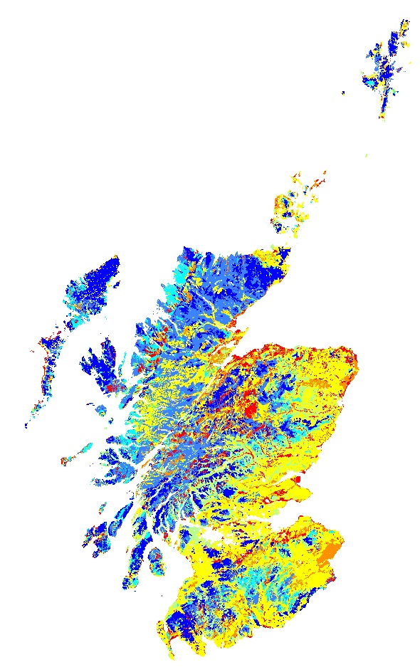
The proportion of water held in the soil at field capacity (5KPa) and at the permanent wilting point (1500kPa) was calculated for each soil horizon of each soil taxonomic unit (soil series) delineated within the 1:250 000 national soil map of Scotland based on pedotransfer functions (regression equations using median sand, silt, clay and organic carbon contents from the Scottish soils knowledge and information base (SSKIB) derived for soils in the UK (Hollis et al., 2015). The Available Water Content for each horizon was calculated by subtracting the water content at 1500 KPa from the water content at 5 kPa. The horizon thickness was then multiplied by the available water content (mm) and summed for the entire soil profile to 1 m or rock if <1m. The map shows the average available water capacity calculated using the areal proportions of all soils in each 1:250 000 soil map unit. Gagkas, Z., Lilly, A., Baggaley, N. & Donnelly, D. (2019). Map of available water capacity of soils in Scotland. James Hutton Institute. Aberdeen. Please note that this dataset differs significantly to the version of Available Water Capacity published in 2012. The difference results from the use of different regression equations to predict available water capacities (Hollis et al.) and bulk densities. In addition, the data values shown are weighted averages by polygon rather than the AWC of the dominant soil type in the polygon. The earlier version of AWC was published as Lilly, A, Baggaley, N and Donnelly, D. 2012. Map of available water content to 1 metre depth in soils of Scotland. Map prepared for EU project GS-SOIL-Assessment and strategic development of INSPIRE compliant Geodata-Services for European Soil Data. ECP-2008-GEO-318004.
-
The BGS has been commissioned by Defra to provide guidance on what are 'normal' levels of contaminant concentrations in English soils in support of the revision of the Part 2A Contaminated Land Statutory Guidance. The domain polygons and other data produced by this work are served as WMS here.
-
Data from the British Geological Survey's GeoIndex Hazards theme are made available for viewing here. GeoIndex is a website that allows users to search for information about BGS data collections covering the UK and other areas world wide. Access is free, the interface is easy to use, and it has been developed to enable users to check coverage of different types of data and find out some background information about the data. More detailed information can be obtained by further enquiry via the web site: www.bgs.ac.uk/geoindex.