 Metadata catalogue
application
Type of resources
Topics
INSPIRE themes
Keywords
Contact for the resource
Provided by
Years
Formats
Update frequencies
status
Service types
Scale
-
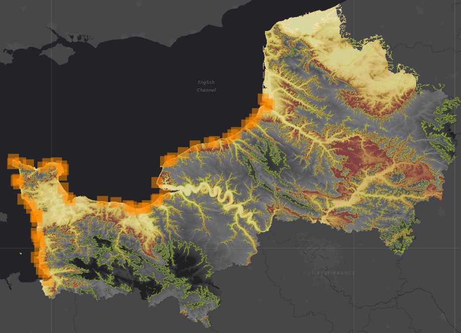
Application cartographique présentant la morphologie et la géologie du littoral de la Normandie et des Hauts-de-France. Sont représentés : - La topographie - La bathymétrie - La géologie - La sédimentologie (nature des fonds, habitats physiques des fonds marins, sédiments superficiels/meubles) - Les types de côtes
-

Map application displays layers, thematically divided according to the geophysical methods used for the data acquisition. The map application contains the geophysical measurements paid by the Czech state, carried out mainly by former company Geofyzika Brno. Application displays the following map layers: seismic (2D reflection seismic and well shoots), vertical electric sounding (polygons, lines, points) and localization of the geophysical surveys on the territory of the Czech Republic (both regional and local).
-

Example Map Application Pre-Quarternary Map.
-

ASGI - Automated System of Geological Information application allows unified access and parametric search of reports and opinions saved in all CGS archives. It’s primarily documentation of Geofond department archive under the Act of geological projects and expert outputs from organization since it’s foundation. Besides detail information about reports allows thumbnail of digitized documents. Some documents from another geological organizations archives are also available.
-

CGS map server application allows statistical data of radon hazard for Czech's administrative units. Data was processed by CGS and State Office for Nuclear Safety under the Czech Republic Radon Program. Application operates with the Geological map 1 : 50,000 and 1 : 500,000. It's possible to generate komplex radon information in PDF format for municipality centroids.
-
Website of theproject "Research on a thermally loaded rock - perspectives of underground thermal energy storage" (2011-2014). The aim of the project was to study the thermal energy flow in the rock environment built of granitic rocks, both in terms of efficiency as well as safety.
-

This application "Geologically documented objects" enables the user to buy his selected data from the database of the geologically documented objects of the Czech Republic (scil. borehole database) managed by the CGS using credit on his account. The database covers the territory of the CR and contains information on about 687 000 documented objects (boreholes, shafts, quarries, caves, wells, surface streams, reservoirs etc.) including 615 000 borehole profiles and 95 000 hydrogeological records. To find the desired objects the user can use a built-in map application or search the database by attributes.
-

Application displays Radon index map of the bedrock of the Czech Republic at a scale of 1 : 50,000 from mapping activities during 1999–2005. It's possible to search by year of publishing, map name and map sheet number. Application is available also on CD-ROM (e-shop).
-
Website of the CzechGeo/EPOS consortium (Comprehensive system for observing geophysical fields operated by geoscience institutions in the Czech Republic). The purpose of this website is to be the main platform of the geophysical community for obtaining information about activities in this field and for informing the public. The website functions as a central signpost for access to geophysical, geodetic and geological data and services in the Czech Republic.
-