 Metadata catalogue
5000000
Type of resources
Topics
INSPIRE themes
Keywords
Contact for the resource
Provided by
Years
Formats
Representation types
Update frequencies
status
Scale
Resolution
-
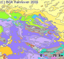
The 1:5 Million International Geological Map of Europe and Adjacent Areas shows the pre-Quarternary geology of Europe onshore and offshore. In addition to the geology attributed by age, petrography and genesis, also magnetic anomalies, tectonic structures, metamorphism and – in the offshore areas – information about the continental/oceanic crust and the continental margin, are shown. The map was developed by BGR under the umbrella of the Commission of the Geological Map of the World (CGMW) and in cooperation with geological surveys organisations of 48 countries and more than 20 research institutes. For detailed information about the 'IGME 5000: More than just a map – A multinational GIS Project' please visit the IGME website.
-
Overview map showing the approximate extent of the key Cobalt metallogenic areas in Europe.
-

The map sheet: 1. Carte hydrologique des stations exploitées en 1973 : République unie du Cameroun. Scale of 1:5 000 000. Date of publication: 1973.
-
Overview map showing the approximate extent of the key Rare Earth Elements (REE) metallogenic areas in Europe.
-
Overview map showing the approximate extent of the key Niobium metallogenic areas in Europe.
-

The prawn (Nephrops norvegicus) are common around the Irish coast occurring in geographically distinct sandy/muddy areas were the sediment is suitable for them to construct their burrows. Nephrops spend a great deal of time in their burrows and their emergence from these is related to time of year, light intensity and tidal strength. This is the spatial dataset of the Nephrops Functional Units statistical rectangle sub-division.
-

The map sheet: 1. Densité de la population en Afrique Occidentale et Equatoriale : par Circonscriptions Administratives. Scale of 1:5 000 000. Date of publication: unknown.
-

A set of 4 map sheets: 1. Carte géologique : bassin de la Sanaga : carte II. Scale of 1:5 000 000. Date of publication: 1975. 2. Croquis pédologique du bassin de la Sanaga : carte III. Scale of 1:5 000 000. Date of publication: 1975. 3. Isohyètes interannuelles : période homogéneisée 1930-1931 à 1969-1970 : bassin de la Sanaga : carte IV. Scale of 1:5 000 000. Date of publication: 1975. 4. Réseau hydrographique hypsométrie : bassin de la Sanaga : carte I. Scale of 1:5 000 000. Date of publication: 1975.
-
Overview map showing the approximate extent of the key Graphite metallogenic areas in Europe.
-

The map sheet: 1. Esquisse géologique et gravimétrique du bassin du Tchad. Scale of 1:5 000 000. Date of publication: 1969.