 Metadata catalogue
forest resource assessment
Type of resources
Available actions
Topics
Keywords
Contact for the resource
Provided by
Years
Formats
Representation types
Update frequencies
status
Scale
-

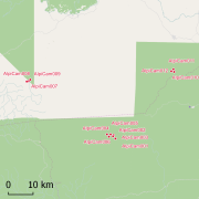
This dataset gathers the floristic composition in a network of about 100 transects across terra firme forests in Gabon, considering stems above or equal to 5 cm diameter at breast height. In each transect, the following data are collected : 1. Diameter at breast height (dbh), 2. Species identification. Herbarium samples are conserved at the Herbarium of the Université Libre de Bruxelles (BRLU, Belgium) and the database is frequently updated by ULB's botanists. 3. GPS geolocation. These data are collected and used by Evolutionnary Biology and Ecology unit from the Université Libre de Bruxelles (ULB) and Missouri Botanical Garden (MBG), Central Africa Program.
-
Africadiv is a network of 1-ha forest monitoring plots spread across the moist forests in central Africa. This dataset holds the biomass calculated from plot inventory data......
-

The site Crique Bastien is composed of two 3km-transects (20m wide). 2608 trees with dbh>=20cm have been recorded by Office national des forêts (ONF). No fauna inventories available. No under-storey plants inventories are available. Soils have been described using 3 samples (1.20m depth max.). No laboratory analysis available for soils.
-

Guyafor is a network of permanent forest plots installed in French Guiana. The site of Risquetout covers a 23,7ha area. It is composed of 4 plots managed by ONF. 7174 trees are being followed since 1995. 9 campaignes of inventories have been made in 1995, 1999, 2001, 2002, 2003, 2004, 2006, 2008, 2009.
-

The site Limonade is composed of three 3km-transects (20m wide). 3354 trees with dbh>=20cm have been recorded by Office national des forêts (ONF). Fauna inventories have been made by Office national de la chasse et de la faune sauvage (ONCFS) few days after. No under-storey plots on this site. Soils have been described using 16 samples (1.20m depth max.). No laboratory analysis available for soils.
-

Guyafor is a network of permanent forest plots installed in French Guiana. The site of Montagne Tortue covers a 19,2ha area. It is composed of 3 plots managed by ONF. 9210 trees are being followed. 5 campaignes of inventories have been made in 2002, 2005, 2007, 2009, 2010.
-

The Nouragues forestry experimental site is located the Nouragues experimental station in French Guiana (other experimental sites than Nouragues plots are established in Nouragues station). This experimental site is composed by several plots not contiguous, some of them are divided into smaller plots (1ha). For each plot, the following information is recorded for all trees and lianas with DBH ≥ 10cm : 1. location of individuals inside the plot, 2. botanical identification (when it is possible), 3. diameter at breast height, or 30 cm above last aerial root, last buttress or last irregularity, 4. total height of tree (subsample). Since 2012, on Grand Plateau and Petit Plateau : 1. coefficient of light exposure 2. coefficient of infestation by lianas in tree crown.
-

The site Waki is composed of 4 3km-transects (20m wide). 5106 trees with dbh>=20cm have been recorded by Office national des forêts (ONF). Fauna have been inventoried few days after (ONCFS). 910 under-storey plants have been inventoried on 39 plots (IRD). Soils have been described using 25 samples (1.20m depth max.) and 4 soil pits. Laboratory analysis are available for one soil profiles and the four soil pits.
-

This “Inventaire Papetier” was conducted by ONF in 1976. The block covers 22 087 ha. 54 020 trees have been inventoried in 235 plots (164 ha) Pre-census DBH is 10 cm on one plot out of two and 40 cm on the others. DBH have been measured by classes with a range of 10 cm. Plots have been located on GIS in 2010 using original maps and field note-books (indicating slopes, rivers, etc...).
-

This “Inventaire Papetier” was conducted by the CTFT in 1975. The block covers 59 895 ha. 34 016 trees have been inventoried in 244 plots (120 ha) Pre-census DBH is 15 cm on all plot (originally trees with DBH 10-15cm have been measured on one plot out of 10 but not included in the digital version) DBH have been measured by classes : 15-20 cm for the first class and with a range of 10 cm since 20 cm. Plots have been located on GIS in 2008 using original maps and field note-books (indicating slopes, rivers, etc...).