 Metadata catalogue
Temperature of the water column
Type of resources
Available actions
Topics
INSPIRE themes
Keywords
Contact for the resource
Provided by
Years
Formats
Representation types
Update frequencies
Scale
Resolution
-

The data recorded by the oceanographic platforms operate in the Aegean and the Ionian Seas (fixed stations, ferry box system, gliders) are released through the POSEIDON portal. Physical and biochemical parameters of the marine environment as well as atmospheric parameters in the fixed station locations are available both in real time and delayed mode. The forecasting module of the POSEIDON system consists of four numerical models that provide in daily basis forecasts regarding the atmospheric, sea state, hydrodynamic and ecological conditions of the Eastern Mediterranean. The online POSEIDON database contains the data recorded by the insitu platforms offering also downloading functions for the whole data set, while a user-friendly tool is also available for accessing the results of all the forecasting models for the last five years.
-
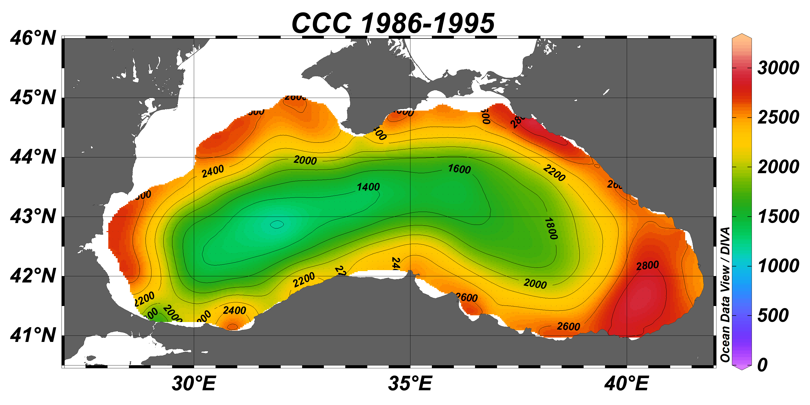
Black Sea gridded decadal annual climatology for cold intermediate layer (CIL) cold content (CCC) (1/8°, 56 sliding decades) based on the collection of temperature and salinity profiles spanning 65 years (1955–2019).The CCC climatological fields were computed from the merged Black Sea dataset that combines data extracted from 3 major sources: 1) SeaDataNet infrastructure, 2) World Ocean Database, and 3) Coriolis Ocean Dataset for Reanalysis. The computation was done with the DIVAnd (Data-Interpolating Variational Analysis in n dimensions), version 2.6.2. The product was developed in framework of SeaDataCloud project, EC H2020 grant #730960. For data access please register at http://www.marine-id.org/.
-
The Black Sea gridded monthly climatology for cold intermediate layer (CIL) cold content (CCC) (1/8°, 12 months) based on the collection of temperature and salinity profiles spanning 35 years (1955–1999).The CCC climatological fields were computed from the merged Black Sea dataset that combines data extracted from 3 major sources: 1) SeaDataNet infrastructure, 2) World Ocean Database, and 3) Coriolis Ocean Dataset for Reanalysis. The computation was done with the DIVAnd (Data-Interpolating Variational Analysis in n dimensions), version 2.6.2. The product was developed in framework of SeaDataCloud project, EC H2020 grant #730960. For data access please register at http://www.marine-id.org/.
-

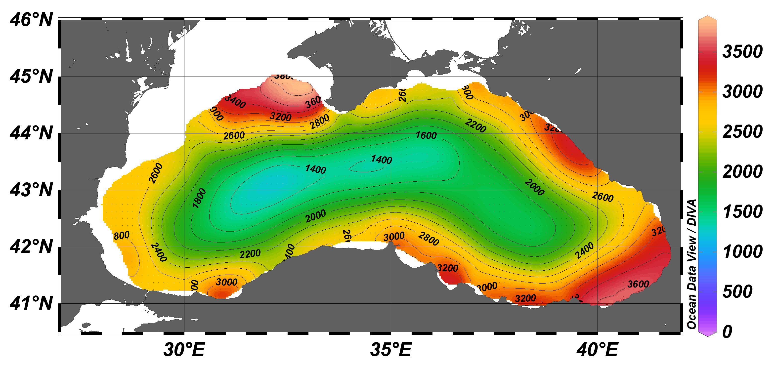
Black Sea gridded decadal seasonal climatology for cold intermediate layer (CIL) cold content (CCC) (1/8°, 6 decades, 4 seasons) based on the collection of temperature and salinity profiles spanning 60 years (1955–2014).The CCC climatological fields were computed from the merged Black Sea dataset that combines data extracted from 3 major sources: 1) SeaDataNet infrastructure, 2) World Ocean Database, and 3) Coriolis Ocean Dataset for Reanalysis. The computation was done with the DIVAnd (Data-Interpolating Variational Analysis in n dimensions), version 2.6.2. The product was developed in framework of SeaDataCloud project, EC H2020 grant #730960. For data access please register at http://www.marine-id.org/.
-
Glider HCMR
-

FERRY is installed on the coastal steamer MV Vesterålen measuring T, S, Chlorophyll fluorescence and oxygen permanently as well as 30 individual samples are taken on all roundtrips from Bergen-Kirkenes and back. This roundtrip is repeated every 11 days throughout the year.
-

The National Glider Facility (GNF) is held by DT-INSU. It is installed inside the Mediterranean Ifremer center and is part of the CETSM (European Centre of underwater technologies). GNF started in September 2008. It is manned by 3 engineers and 1 technician and operates 10 gliders. The facility is fully equipped with: a glider ballasting tank, an electronic lab for pre-deployment preparation, servers and communications devices for glider operations. It is linked to the ego-network.org web page offering a collaborative work environment and tools for piloting gliders. The following sensors can be mounted on the gliders: CTD, Oxygen Optode, Fluorimeters (ChlA, CDOM, Phycoerythrine, turbidity), Back scattering (470-880 nm).
-

This autonomous platform is deployed at the mouth of the bay of Villefranche-sur-mer, (43°40’54.16”N; 07°19’10.48”E). It is moored over rocky bottom depth of 90 m. As no continental platform is present in this area, this site is under offshore influences, for physical parameters as well as for biological ones. Its equipment comprises: a meteorological station (station Vaisala WXT 520), a winch dedicated to ctd (temperature and salinity at the moment, extension to others sensors in the future) profiles. Core oceanographic parameters (temperature, salinity, fluorescence, dissolved oxygen) are acquired with a SeaBird SBE19 on an hourly basis at a fixed depth (1.5 m). A fixed pH sensor is deployed in a developmental phase of validation.
-

SeaDataNet Temperature and Salinity historical data collection for the North Arctic Ocean, including revised quality flags after quality control with ODV. For data access please register at http://www.marine-id.org The dataset format is ODV binary collections. You can read, analyse and export from the ODV application provided by Alfred Wegener institute at http://odv.awi.de/
-

ISMAR OS is a system around Italy and is composed by 11 fixed platforms, HF radars, a glider. The installations proposed for TNA embrace different marine environments and can be used independently. SiCO is a twin-mooring system placed is in a key area connecting the Eastern and Western Mediterranean Sea. Equipped with current profilers and CTD probes, it continuously monitor surface and intermediate exchange of water masses and properties between the basins. A pCO2 probe is installed in SiCO1 near the bottom to widen the contribution of the observatory to climate studies and ocean acidification research. The site is part of the CIESM Hydro-Changes Programme.