Metadata catalogue
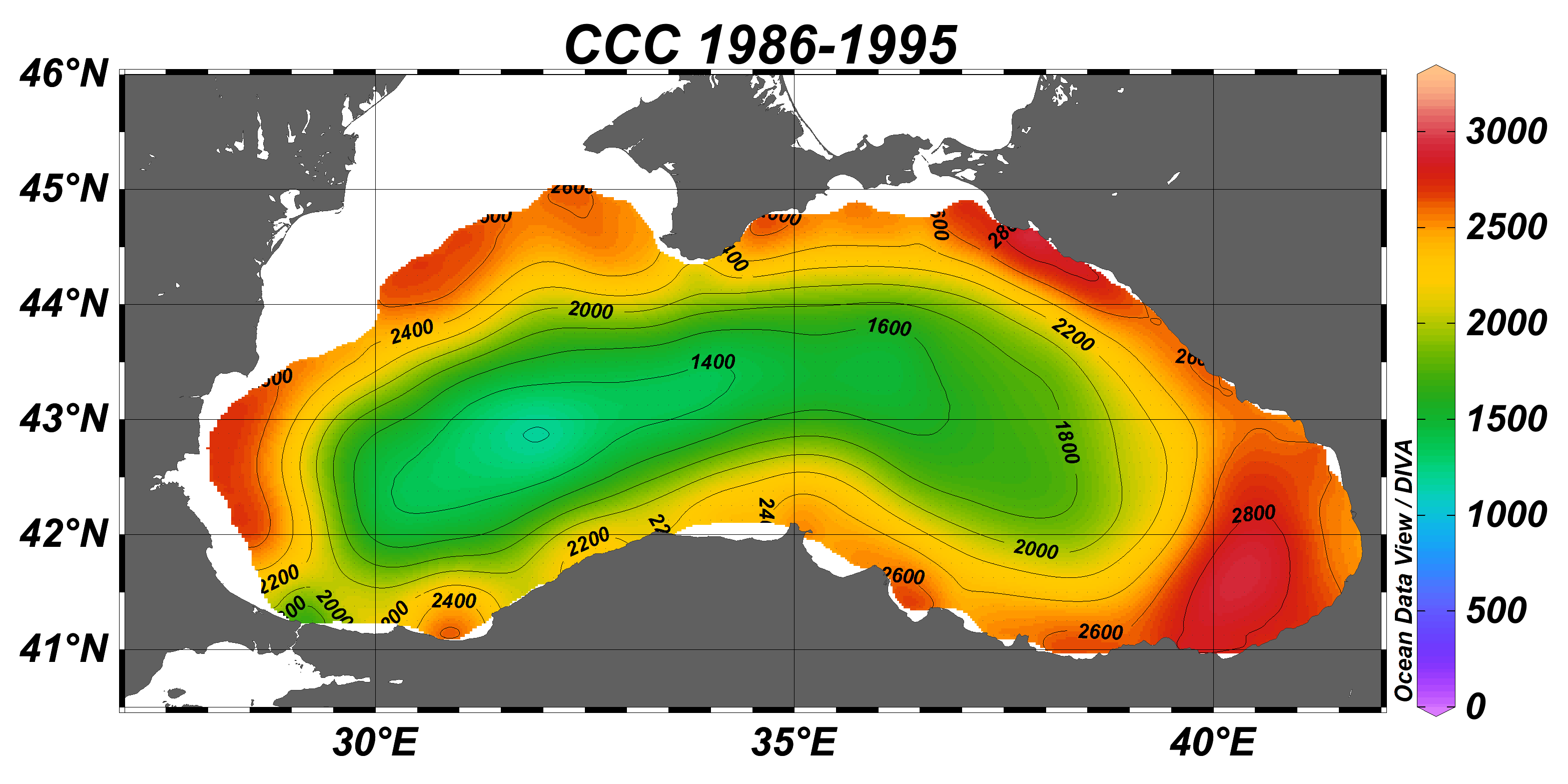
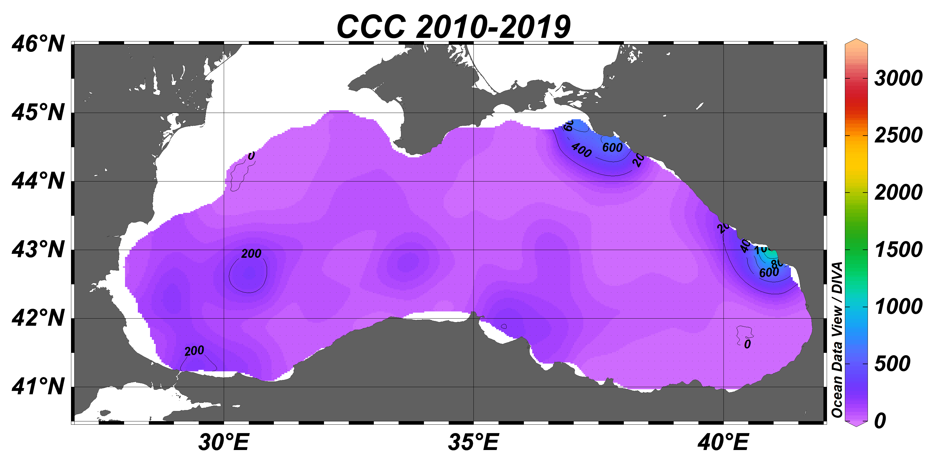
Black Sea gridded climatology - sliding decades - for cold intermediate layer cold content at 1/8°
Black Sea gridded decadal annual climatology for cold intermediate layer (CIL) cold content (CCC) (1/8°, 56 sliding decades) based on the collection of temperature and salinity profiles spanning 65 years (1955–2019).The CCC climatological fields were computed from the merged Black Sea dataset that combines data extracted from 3 major sources: 1) SeaDataNet infrastructure, 2) World Ocean Database, and 3) Coriolis Ocean Dataset for Reanalysis. The computation was done with the DIVAnd (Data-Interpolating Variational Analysis in n dimensions), version 2.6.2. The product was developed in framework of SeaDataCloud project, EC H2020 grant #730960.
For data access please register at http://www.marine-id.org/.
|
|
Citation proposal
IFREMER / IDM / SISMER - Scientific Information Systems for the SEA - Volodymyr Myroshnychenko (METU). Black Sea gridded climatology - sliding decades - for cold intermediate layer cold content at 1/8°. https://services.mspdata.eu:/geonetwork/srv/api/records/6fe2500a-bc95-494c-9697-65ee84ab44c9 |
Simple
- Alternate title
- SDC_BLS_DP3
- Date ( Creation )
- 2020-10-01
- Edition
- 1
- Edition date
- 2018-02-20
- Identifier
- 2287615d-1977-479f-8d5b-439960bcb21a
- Credit
- SeaDataNet
Point of contact
Resource provider
Custodian
IFREMER Centre de Bretagne
ZI Pointe du diable
CS 10070
PLOUZANE 29280 FranceOriginator
Author
- GEMET - INSPIRE themes, version 1.0 ( Theme )
-
- Oceanographic geographical features
- Parameter Discovery Vocabulary (P02) ( parameter )
-
- Temperature of the water column
- EMODnet Chemistry aggregated parameter names ( parameter )
-
- SeaVoX salt and fresh water body gazetteer ( reference-geographical-area )
-
- Black Sea
- Thèmes Sextant ( Theme )
-
- /Physical Environment/Climatology
- Use limitation
- SeaDataNet Usage Agreement: If you use SeaDataNet data in your publications please include the following in the Acknowledgements: Data were provided through SeaDataNet Pan-European infrastructure for ocean and marine data management (https://www.seadatanet.org)
- Access constraints
- Other restrictions
- Other constraints
- No limitations on public access. For data access please register at http://www.marine-id.org
- Metadata language
- English
- Topic category
-
- Oceans
- Description
- bounding box
))
Vertical extent
- Reference system identifier
- EPSG / WGS 84 (EPSG 4326)
Spatial representation info
- Distribution format
-
- ODV binary collection (5 )
- OnLine resource
-
DOI of the product
DOI of the product
- OnLine resource
- full collection dataset
- Protocol
- WWW:LINK
- Protocol
- WWW:DOWNLOAD-1.0-http--download
- Hierarchy level
- Series
Conformance result
- Date ( Publication )
- 2010-12-08
- Explanation
- See the referenced specification
- Statement
- The data used as input for this product have been extracted from the merged Black Sea dataset that combines data from 3 major sources: 1) SeaDataNet infrastructure, 2) World Ocean Database, and 3) Coriolis Ocean Dataset for Reanalysis.
Metadata
- File identifier
- 6fe2500a-bc95-494c-9697-65ee84ab44c9 XML
- Metadata language
- English
- Character set
- UTF8
- Hierarchy level
- Dataset
- Date stamp
- 2020-12-10T14:26:27
- Metadata standard name
- ISO 19115:2003/19139 - EMODNET - SDN
- Metadata standard version
- 0.1