 Metadata catalogue
ZIP
Type of resources
Available actions
Topics
INSPIRE themes
Keywords
Contact for the resource
Provided by
Years
Formats
Representation types
Update frequencies
status
Service types
Scale
Resolution
-
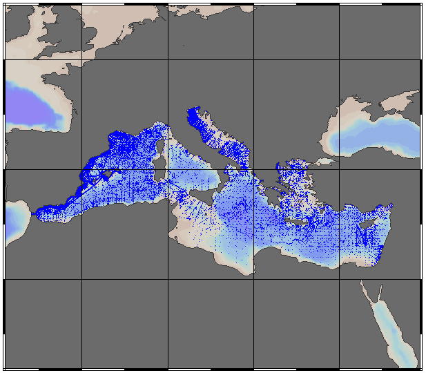
EMODnet Chemistry aims to provide access to marine chemistry data sets and derived data products concerning eutrophication, acidity and contaminants. The chemicals chosen reflect importance to the Marine Strategy Framework Directive (MSFD). ITS-90 water temperature and Water body salinity variables have been also included (as-is) to complete the Eutrophication and Acidity data. If you use these variables for calculations, please refer to SeaDataNet for having the quality flags: https://www.seadatanet.org/Products/Aggregated-datasets . This aggregated dataset contains all unrestricted EMODnet Chemistry data on Eutrophication and Acidity (15 parameters with quality flag indicators), and covers the Mediterranean Sea with 187722 CDI records (180932 Vertical profiles and 6790 Time series). Vertical profiles temporal range is from 1911-08-17 to 2020-10-16. Time series temporal range is from 1974-06-04 to 2018-02-20. Data were aggregated and quality controlled by 'Hellenic Centre for Marine Research, Hellenic National Oceanographic Data Centre (HCMR/HNODC)' from Greece. Regional datasets concerning eutrophication and acidity are automatically harvested and resulting collections are aggregated and quality controlled using ODV Software and following a common methodology for all Sea Regions ( https://doi.org/10.6092/9f75ad8a-ca32-4a72-bf69-167119b2cc12). When not present in original data, Water body nitrate plus nitrite was calculated by summing up the Nitrates and Nitrites. Same procedure was applied for Water body dissolved inorganic nitrogen (DIN) which was calculated by summing up the Nitrates, Nitrites and Ammonium. Parameter names are based on P35, EMODnet Chemistry aggregated parameter names vocabulary, which is available at: https://www.bodc.ac.uk/resources/vocabularies/vocabulary_search/P35/. Detailed documentation is available at: https://dx.doi.org/10.6092/4e85717a-a2c9-454d-ba0d-30b89f742713 Explore and extract data at: https://emodnet-chemistry.webodv.awi.de/eutrophication%3EMediterranean The aggregated dataset can also be downloaded as ODV collection and spreadsheet, which is composed of metadata header followed by tab separated values. This spreadsheet can be imported to ODV Software for visualisation (More information can be found at: https://www.seadatanet.org/Software/ODV ). The original datasets can be searched and downloaded from EMODnet Chemistry Download Service: https://emodnet-chemistry.maris.nl/search
-
A 30-year (1971-2000) temperature and salinity climatology is presented for surface and near-bed regions of the NW European shelf seas, with a resolution of 1/6 longitude by 1/10 latitude. The data have been extracted from the International Council for the Exploration of the Sea (ICES) data centre and supplemented by additional records from the World Ocean Data Centre (WODC). From the original data, which are irregularly distributed in space and time, the mean monthly temperature and salinity are calculated, as well as the climatic mean annual cycle. The climatology presented here is an improvement upon all existing climatologies presented in the literature for the NW European shelf; covering a wider area on a finer scale and including the surface and near-bed distribution of both temperature and salinity. Comparison of our data with existing climatologies shows good agreement, with differences occurring where our climatology is an improvement. This climatology, which will prove to be valuable to many users in the marine community will be regularly updated and made available to all users via the ICES data centre.
-
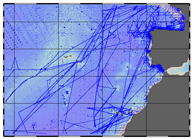
EMODnet Chemistry aims to provide access to marine chemistry data sets and derived data products concerning eutrophication, acidity and contaminants. The chemicals chosen reflect importance to the Marine Strategy Framework Directive (MSFD). ITS-90 water temperature and Water body salinity variables have been also included (as-is) to complete the Eutrophication and Acidity data. If you use these variables for calculations, please refer to SeaDataNet for having the quality flags: https://www.seadatanet.org/Products/Aggregated-datasets . This aggregated dataset contains all unrestricted EMODnet Chemistry data on Eutrophication and Acidity (18 parameters with quality flag indicators), and covers the Northeast Atlantic Ocean (40W) with 381639 CDI records (381085 Vertical profiles and 554 Time series). Vertical profiles temporal range is from 1921-10-15 to 2020-10-16. Time series temporal range is from 1974-06-14 to 2019-04-24. Data were aggregated and quality controlled by 'IFREMER / IDM / SISMER - Scientific Information Systems for the SEA' from France. Regional datasets concerning eutrophication and acidity are automatically harvested and resulting collections are aggregated and quality controlled using ODV Software and following a common methodology for all Sea Regions ( https://doi.org/10.6092/9f75ad8a-ca32-4a72-bf69-167119b2cc12). When not present in original data, Water body nitrate plus nitrite was calculated by summing up the Nitrates and Nitrites. Same procedure was applied for Water body dissolved inorganic nitrogen (DIN) which was calculated by summing up the Nitrates, Nitrites and Ammonium. Parameter names are based on P35, EMODnet Chemistry aggregated parameter names vocabulary, which is available at: https://www.bodc.ac.uk/resources/vocabularies/vocabulary_search/P35/. Detailed documentation is available at: https://dx.doi.org/10.6092/4e85717a-a2c9-454d-ba0d-30b89f742713 Explore and extract data at: https://emodnet-chemistry.webodv.awi.de/eutrophication%3EAtlantic The aggregated dataset can also be downloaded as ODV collection and spreadsheet, which is composed of metadata header followed by tab separated values. This spreadsheet can be imported to ODV Software for visualisation (More information can be found at: https://www.seadatanet.org/Software/ODV ). The original datasets can be searched and downloaded from EMODnet Chemistry Download Service: https://emodnet-chemistry.maris.nl/search
-
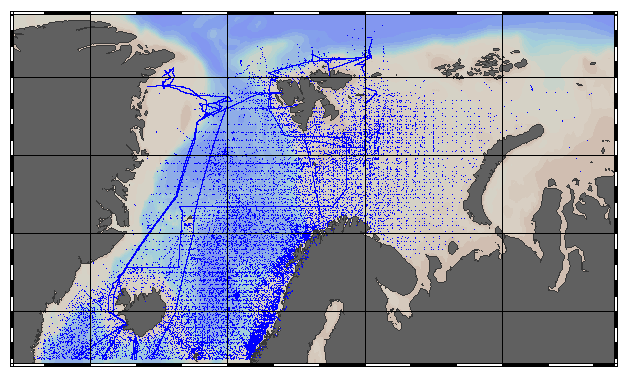
EMODnet Chemistry aims to provide access to marine chemistry data sets and derived data products concerning eutrophication, acidity and contaminants. The chemicals chosen reflect importance to the Marine Strategy Framework Directive (MSFD). This aggregated dataset contains all unrestricted EMODnet Chemistry data on Eutrophication and Acidity (14 parameters with quality flag indicators), and covers the Norwegian Sea, Barents Sea, Greenland Sea and Icelandic Waters with 114721 CDI stations. Data were aggregated and quality controlled by 'Institute of Marine Research - Norwegian Marine Data Centre (NMD)'. Regional datasets concerning eutrophication and acidity are automatically harvested and resulting collections are aggregated and quality controlled using ODV Software and following a common methodology for all Sea Regions ( https://doi.org/10.6092/9f75ad8a-ca32-4a72-bf69-167119b2cc12 ). When not present in original data, Water body nitrate plus nitrite was calculated by summing up the Nitrates and Nitrites. Same procedure was applied for Water body dissolved inorganic nitrogen (DIN) which was calculated by summing up the Nitrates, Nitrites and Ammonium. Parameter names are based on P35, EMODnet Chemistry aggregated parameter names vocabulary, which is available at: https://www.bodc.ac.uk/resources/vocabularies/vocabulary_search/P35/ Detailed documentation is available at: https://dx.doi.org/10.6092/4e85717a-a2c9-454d-ba0d-30b89f742713 Explore and extract data at: https://emodnet-chemistry.webodv.awi.de/eutrophication>Arctic The aggregated dataset can also be downloaded as ODV collection and spreadsheet, which is composed of metadata header followed by tab separated values. This spreadsheet can be imported to ODV Software for visualisation (More information can be found at: https://www.seadatanet.org/Software/ODV ) The original datasets can be searched and downloaded from EMODnet Chemistry Download Service: https://emodnet-chemistry.maris.nl/search
-

Lors de l’élaboration du diagnostic régional de la biodiversité, publié en 2009, neuf régions naturelles ont été définies en s’appuyant sur les caractéristiques physiques du territoire (géologie, relief/topographie, climat).
-

Le GIP est l'organisme chargé par l'Etat de mettre en place un Parc national des forêts feuillues de plaine entre la Côte-d'Or (Bourgogne) et la Haute-Marne (Champagne-Ardenne). Ce périmètre, composé des communes adhérentes et de quelques communes non adhérentes, est issu de l'Assemblée générale du 9 juillet 2013.
-

En 2014, le GIP de préfiguration du Parc national des forêts de Champagne et Bourgogne a lancé une étude, réalisée par Biotope, visant à synthétiser la connaissance existante sur les habitats naturels de son périmètre. Le résultat de cette étude est une table de localisation des 257 associations (ou groupements équivalents), répartis au sein de 34 classes phytosociologiques.
-

La pluviométrie en période de recharge est le cumul des précipitations tombées d'octobre à mars, comptées en hauteurs d’eau et exprimées en millimètres. La méthode de spatialisation utilisée est une méthode de résolution fine (1 km) prenant en compte le relief (méthode AURELHY) et appliquée aux observations relevées sur la période 1981-2010. La période 1981-2010 constitue la dernière période de référence en cours, qui correspond à la durée recommandée par l'Organisation Météorologique Mondiale pour établir des statistiques climatologiques.
-

Les températures maximales moyennes au printemps sont les moyennes arithmétiques des valeurs maximales quotidiennes de températures relevées de mars à mai. La méthode de spatialisation utilisée est une méthode de résolution fine (1 km) prenant en compte le relief (méthode AURELHY) et appliquée aux observations relevées sur la période 1981-2010. La période 1981-2010 constitue la dernière période de référence en cours, qui correspond à la durée recommandée par l'Organisation Météorologique Mondiale pour établir des statistiques climatologiques.
-
Cette couche présente un découpage du département de la Sarthe en douze régions floristiques. Celles-ci sont définies sur la base d'une analyse de la similarité de la composition floristique (multispati, Dray et al. 2008) à partir des données de la base Flora. Pour chaque région floristique, les espèces indicatrices qui la caractérise sont indiquées.