 Metadata catalogue
/Biological oceanography/Fish
Type of resources
Available actions
Topics
INSPIRE themes
Keywords
Contact for the resource
Provided by
Years
Representation types
status
-

Explore global fisheries and aquaculture. Understand their status and how impacts are being managed. Learn what improvements are underway, and see what actions seafood stakeholders can take to drive sustainability. FishSource is a publicly available online resource about the status of fisheries, fish stocks, and aquaculture. FishSource compiles and summarizes publicly available scientific and technical information and presents it in an easily interpretable form. FishSource was created in 2007 by Sustainable Fisheries Partnership to provide major seafood buyers with up-to-date, impartial, and actionable information on the sustainability of fisheries and the improvements they need to make to become more sustainable. In 2018, information on aquaculture sources was added to the database to provide FishSource users with a more robust tool that covers all types of seafood production. Although the primary intended audience of FishSource is seafood businesses, other audiences - such as academics, researchers, and non-profit organizations - have also become frequent and welcomed users of FishSource. The information on FishSource is primarily developed and updated by a small team of in-house analysts, but their capacity is recognizably insufficient to maintain complete coverage of all global fisheries. As such, profiles may be incomplete or information may be out of date. The seafood industry and external contributors are invited to help fill any gaps that they consider priorities through our Rapid Assessment Program. FishSource always welcome comments on any of our profiles and encourage an open debate on the sources of information used and our interpretation of the data. Our objective is to use only publicly available sources and fully credit those sources, effectively acting as an inventory of information sources on fisheries and aquaculture.
-

Accredited through the MEDIN partnership, and core-funded by the Department for the Environment, Food and Rural Affairs (Defra) and the Scottish Government, DASSH provides tools and services for the long-term curation, management and publication of marine species and habitats data, within the UK and internationally. Below are a selection of projects, outputs and deliverables that DASSH and the MBA Data Team have been involved in recently. - NE Data Management: DASSH have been contracted by the Marine team at Natural England (NE) to support NE data dissemination. We have been digitising datasets used in Article 17 reporting and helping them input data to Marine Recorder and MEDIN guidelines. In addition, DASSH is running a 2-day workshop with the marine data team in October 2014 on data management and standards. The aims of the workshop are to present MEDIN data guidelines and standards and to run practicals on quality assurance (QA) issues with data, creating MEDIN formatted data, and creation of MEDIN metadata. - MCZ Data Archiving: DASSH staff have been working with Defra, JNCC, Natural England, Cefas and the other MEDIN DAC's in the development and implementation of a strategy for the archiving and dissemination of MCZ survey data. This involves the archives of many terrabytes of data from the survey work undertaken at 127 sites. DASSH is currently working with the other DACs archiving the data from several MCZ sites before taking delivery of the complete survey catalogue. - Non-Natives Data Management: DASSH staff work with other members of the KE team to help deliver the MBA contribution to the GB Non-native Species Information Portal. The data team ensure the validation of records submitted and raise alerts when records of Invasive Non-Native Species of concern and in disseminating information about species distribution via DASSH and the NBN. DASSH staff continue to liaise with organisations to ensure the prompt flow of marine non-native species distribution data to the public domain. The KE team facilitated the identification of two new marine invasive non-native species in 2014 and have subsequently created the identification sheet for these species. Hemigrapsus sanguineus (from volunteer records sent in for identification) and Hemigrapsus takanoi (first recorded by the John Bishop Group survey team). - EMODNet Biology: The Data Team are part of a consortium led by the Flanders Marine Institute (VLIZ) for the biological data component of EMODNet (European Marine Observation and Data Network). The Data Team will lead a work package relating to biological traits and indicator species as identified for Marine Strategy Framework Directive (MSFD) reporting, bringing an additional €130k of funding. - VALMER: The Data Team led a key work package in a £3.7 million (ca. €260k for the MBA) INTERREG project to "Develop, trial and refine methodologies that will be used to quantify and communicate the value (economical, social and environmental) of marine and coastal ecosystem services". The research identified an operational framework to value marine ecosystem services, and which could be used to enhance marine planning and policy decisions.
-
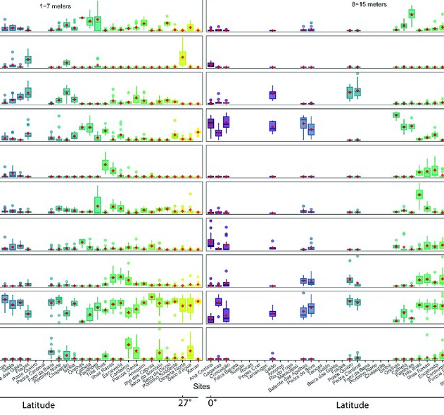
As marine ecosystems are influenced by global and regional processes, standardized information on community structure has become crucial for assessing broad-scale responses to natural and anthropogenic disturbances. Extensive biogeographic provinces, such as the Brazilian Province in the southwest Atlantic, present numerous theoretical and methodological challenges for understanding community patterns on a macroecological scale. In particular, the Brazilian Province is composed of a complex system of heterogeneous reefs and a few offshore islands, with contrasting histories and geophysical-chemical environments. Despite the large extent of the Brazilian Province (almost 8,000 kilometers), most studies of shallow benthic communities are qualitative surveys and/or have been geographically restricted. We quantified community structure of shallow reef habitats from 0° to 27°S latitude using a standard photographic quadrat technique. Percent cover data indicated that benthic communities of Brazilian reefs were dominated by algal turfs and frondose macroalgae, with low percent cover of reef-building corals. Community composition differed significantly among localities, mostly because of their macroalgal abundance, despite reef type or geographic region, with no evident latitudinal pattern. Benthic diversity was lower in the tropics, contrary to the general latitudinal diversity gradient pattern. Richness peaked at mid-latitudes, between 20°S to 23°S, where it was ~3.5-fold higher than localities with the lowest richness. This study provides the first large-scale description of benthic communities along the southwestern Atlantic, providing a baseline for macroecological comparisons and evaluation of future impacts. Moreover, the new understanding of richness distribution along Brazilian reefs will contribute to conservation planning efforts, such as management strategies and the spatial prioritization for the creation of new marine protected areas.
-
.jpg)
Cruise JR 161 was conducted within the Scotia Sea. Three transects were run as follows: 1. From Stanley in the Falkland Islands to Signy, South Orkneys. 2. From Signy towards the Polar Front North of the Island of South Georgia. 3. From the Polar Front back to Stanley. Nine Stations were sampled in total; we remained on 3 stations for 4 days each and 6 stations for 2 days each. At each station we took samples and measurements to characterise the Oceanography, nutrients, phytoplankton, zooplankton, fish and higher predators. The sampling was undertaken as part of the DISCOVERY 2010 BAS programme, with its remit to investigate and describe the response of the Southern Ocean ecosystem to climate variability, climate change and commercial exploitation.
-
.jpg)
This was the third cruise undertaken as part of the NERC-funded consortium project (NE/C512961/1) entitled ECOMAR - Ecosystem of the Mid-Atlantic Ridge at the Sub-Polar Front and Charlie Gibbs Fracture Zone. ECOMAR - Ecosystem of the Mid-Atlantic Ridge at the Sub-Polar Front and Charlie Gibbs Fracture Zone. http://www.oceanlab.abdn.ac.uk/ecomar/index.php ECOMAR forms part of the Census of Marine Life MAR-ECO project which is an international study of life in the northern mid-Atlantic Ocean with scientists from 16 nations participating in research of the waters around the mid-Atlantic Ridge from Iceland to the Azores (http://www.mar-eco.no). Depart: Empress Dock, Southampton, UK, Saturday 1 August 2009 Sonar Calibration: Bantry Bay, Ireland, Monday 3 August 2009 Long term moorings were serviced at four super stations at a bottom depth of 2500m equipped with sediment traps, current meters, ADCP and sensor suites, SE - 49°01.92'N, 27°40.82'W, SW - 48°46.80'N, 28°38.43'W, NW - 53°59.33'N, 36°07.39'W and NE 54°00.05'N34°10.58'W. Video and still images of the sea floor were obtained during 18 lander deployments. Faunas samples were taken with 11 megacorer casts, 6 bottom trawls, 8 baited traps and 8 mid-water trawl tows. 23 CTD casts with one 24 h yoyo sequence investigated water masses, flow and primary productivity over the ridge. EK60 acoustic surveys quantified pelagic biomass and optical remote sensing measured patterns of primary productivity and locations of fronts. During work at the SW station the vessel diverted to Cork, Ireland to repatriate personnel on Friday 14th August. Before starting work at the SE station the vessel diverted to 48°45'N 30°23'W in response to a Mayday call from the vessel Black Knight to rescue lone trans-Atlantic rower Peter Bray on Wednesday 19 August. http://www.peterbrayadventurer.com/ http://www.oceanrowing.com/Peter_Bray/dist_map.htm Sonar Calibration: Bantry Bay, Ireland, Monday 7 September 2009 Arrive: Falmouth, UK, Wednesday 9 September 2009 The ECOMAR area will be revisited by the RRS James Cook with the ISIS ROV in 2010.
-
Fish assemblages surveyed by using underwater visual censuses (UVC) down to 40 m. Transects were performed between 1997 and 2015 in the Azores, Portugal. All mobile fish were identified to the lowest possible taxon. Dates, geographic coordinates and species recorded are provided. Fish assemblages were surveyed using underwater visual censuses (UVC) down to 40 m. Following standard belt transect surveys (Brock 1954), SCUBA divers sampled transects with 50 m length and 5 m width. All mobile fish were identified to the lowest possible taxon and counted. Sampling sites were chosen based on the general representativeness of the habitat. Transects within sites were selected by stratified random sampling: different transects were done in each dive without replicating the depth strata (every 10 m) or overall bottom type or crossing transects during a single dive or day. UVCs were conducted in the scope of projects CLIPE (FCT—Praxis XXI/3/3.2/EMG/1957/95), MARÉ (LIFE B4-3200/98-509), MAREFISH (FCT-POCTI/ BSE/41207/2001), OGAMP (INTERREG IIIb/MAC/4.2/A2 2001), MARMAC (INTERREGIIIb-03/MAC/4.2/A1 2004), EmpaFish (EC-FP6, SSP8-006539), MareFish (FCT, POCTI/BSE/41207/2001), MoniZEC (FRC - M2.1.2/I/018/2011)
-
%20Raw%20Echosounder%20data.jpg)
The overall aim of the Atlantic Meridional Transect programme is: to quantify key biogeochemical and ecosystem processes and their inherent variability over extended time and spatial scales in the Atlantic Ocean. This is achieved by executing an annually repeated meridional transect through contrasting oceanic provinces, ranging from oligotrophic deserts, to highly productive shelf seas. The specific objectives of AMT are: - To quantify the nature and causes of ecological and biogeochemical variability in planktonic ecosystems; - To quantify the effects of this variability on nutrient cycling, on biogenic export and on air-sea exchange of climate active gases; - To construct multi-decadal, multidisciplinary ocean time-series which are integrated within a wider "Pole-to-pole" observatory concept; - To provide essential sea-truth validation for current and next generation satellite missions; - To provide essential data for global ecosystem model development and validation; - To provide a valuable, highly sought after and unique training arena for the next generation of UK and International oceanographers.
-
%20Raw%20Echosounder%20data.jpg)
AMT25: The overall aim of the Atlantic Meridional Transect programme is: to quantify key biogeochemical and ecosystem processes and their inherent variability over extended time and spatial scales in the Atlantic Ocean. This is achieved by executing an annually repeated meridional transect through contrasting oceanic provinces, ranging from oligotrophic deserts, to highly productive shelf seas. Specific objectives: - To quantify the nature and causes of ecological and biogeochemical variability in planktonic ecosystems; - To quantify the effects of this variability on nutrient cycling, on biogenic export and on air-sea exchange of climate active gases; - To construct multi-decadal, multidisciplinary ocean time-series which are integrated within a wider "Pole-to-pole" observatory concept; - To provide essential sea-truth validation for current and next generation satellite missions; - To provide essential data for global ecosystem model development and validation; - To provide a valuable, highly sought after and unique training arena for the next generation of UK and international oceanographers. JR864: The oceanographic research ship RRS James Clark Ross attempted to physically and biologically characterise Ascension Island's shelf from 14th-18th October 2015. Multibeam sonar swath was used to generate the first open-access, high resolution mapping of Ascension Island's seabed between 100-1100m depth. These data was used to determine seabed profile and rugosity characteristics. Seabed substratum was investigated using a benthic camera lander (SUCS) and water column physico-chemistry was gained using CTD. The SUCS provided 500 photographs and video clips of benthos from 21 site/depth combinations, which showed a wide disparity in richness and density of biodiversity. These were ground-truthed by targeted Agassiz trawl samples to collect vouchers specimens for morphological and genetic identification. Specimens collected were photographed, fixed and then preserved in 96% ethanol for later genetic analyses. Preliminary analysis of the biodiversity captured was undertaken in the Conservation Department building, Georgetown, Ascension Island and indicated new records for the Island including first records of brachipods.
-
%20Raw%20Echosounder%20data.jpg)
The overall aim of the Atlantic Meridional Transect programme is: to quantify key biogeochemical and ecosystem processes and their inherent variability over extended time and spatial scales in the Atlantic Ocean. This is achieved by executing an annually repeated meridional transect through contrasting oceanic provinces, ranging from oligotrophic deserts, to highly productive shelf seas. The specific objectives of AMT are: - To quantify the nature and causes of ecological and biogeochemical variability in planktonic ecosystems; - To quantify the effects of this variability on nutrient cycling, on biogenic export and on air-sea exchange of climate active gases; - To construct multi-decadal, multidisciplinary ocean time-series which are integrated within a wider “Pole-to-pole” observatory concept; - To provide essential sea-truth validation for current and next generation satellite missions; - To provide essential data for global ecosystem model development and validation; - To provide a valuable, highly sought after and unique training arena for the next generation of UK and International oceanographers.
-
%20Raw%20Echosounder%20data.jpg)
The overall aim of the Atlantic Meridional Transect programme is: to quantify key biogeochemical and ecosystem processes and their inherent variability over extended time and spatial scales in the Atlantic Ocean. This is achieved by executing an annually repeated meridional transect through contrasting oceanic provinces, ranging from oligotrophic deserts, to highly productive shelf seas. The specific objectives of AMT are: - To quantify the nature and causes of ecological and biogeochemical variability in planktonic ecosystems; - To quantify the effects of this variability on nutrient cycling, on biogenic export and on air-sea exchange of climate active gases; - To construct multi-decadal, multidisciplinary ocean time-series which are integrated within a wider "Pole-to-pole" observatory concept; - To provide essential sea-truth validation for current and next generation satellite missions; - To provide essential data for global ecosystem model development and validation; - To provide a valuable, highly sought after and unique training arena for the next generation of UK and International oceanographers.