 Metadata catalogue
Dissolved oxygen parameters in the water column
Type of resources
Available actions
Topics
INSPIRE themes
Keywords
Contact for the resource
Provided by
Years
Formats
Representation types
Scale
Resolution
-

Glider HCMR
-

This autonomous platform is deployed at the mouth of the bay of Villefranche-sur-mer, (43°40’54.16”N; 07°19’10.48”E). It is moored over rocky bottom depth of 90 m. As no continental platform is present in this area, this site is under offshore influences, for physical parameters as well as for biological ones. Its equipment comprises: a meteorological station (station Vaisala WXT 520), a winch dedicated to ctd (temperature and salinity at the moment, extension to others sensors in the future) profiles. Core oceanographic parameters (temperature, salinity, fluorescence, dissolved oxygen) are acquired with a SeaBird SBE19 on an hourly basis at a fixed depth (1.5 m). A fixed pH sensor is deployed in a developmental phase of validation.
-

Data access will be provided in near real time and in delayed mode. Parameters include salinity, temperature, chlorophyll fluorescence, turbidity, oxygen, pH, pCO2, wave height and direction, current speed and direction and also in air data on temperature, irradiation and air pressure. Also data from laboratory analyses of water samples are included, e.g. chlorophyll, salinity, CDOM, coloured dissolved organic matter, phytoplankton abundance and biodiversity. Data is distributed through the Baltic Operational Oceanographic System, BOOS and through the Swedish Oceanographic Data Centre at SMHI. Data is accessible through download and through web services. Data and metadata is delivered through SMHI systems for distributing oceanographic data, e.g. http://sharkdata.smhi.se according to EU standards and procedures.
-

MOLIT is designed for in situ monitoring in large rivers, estuaries and coastal areas. It is used for since many years in the Loire estuary where a two level sampling, surface and 10 m depth, is performed with multiparameter measurements (T, DO, salinity, turbidity, fluorescence). Nevertheless, if needed, the MOLIT hydraulic system can perform sampling at 4 different levels. The whole hydraulic sampling system is protected from bio-fouling by an efficient seawater electrolysis scheme; this bio-fouling protection can be used to protect the tested instruments. The data are available by a wireless communication system or can be stored on board.
-
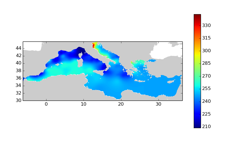
Moving 10-years analysis of dissolved_oxygen_concentration at Mediterranean Sea for each season : - winter (January-March), - spring (April-June), - summer (July-September), - autumn (October-December). Every year of the time dimension corresponds to the 10-year centered average of each season. Decades span from 1971-1980 until 2006-2015. Observational data span from 1911 to 2015. Depth range (IODE standard depths):-3000.0, -2500.0, -2000.0, -1750.0, -1500.0, -1400.0, -1300.0, -1200.0, -1100.0, -1000.0, -900.0, -800.0, -700.0, -600.0, -500.0, -400.0, -300.0, -250.0, -200.0, -150.0, -125.0, -100.0, -75.0, -50.0, -30.0, -20.0, -10.0, -5.0, -0.0. Data Sources: observational data from SeaDataNet/EMODNet Chemistry Data Network. Description of DIVA analysis: Geostatistical data analysis by DIVA (Data-Interpolating Variational Analysis) tool. Profiles were interpolated at standard depths using weighted parabolic interpolation algorithm (Reiniger and Ross, 1968). GEBCO 1min topography is used for the contouring preparation. Analyzed filed masked using relative error threshold 0.3 and 0.5. DIVA settings: A constant value for signal-to-noise ratio was used equal to 1. Correlation length was optimized and filtered vertically and a seasonally-averaged profile was used. Logarithmic transformation applied to the data prior to the analysis. Background field: the data mean value is subtracted from the data. Detrending of data: no. Advection constraint applied: no. Originators of Italian data sets-List of contributors: o Brunetti Fabio (OGS) o Cardin Vanessa, Bensi Manuel doi:10.6092/36728450-4296-4e6a-967d-d5b6da55f306 o Cardin Vanessa, Bensi Manuel, Ursella Laura, Siena Giuseppe doi:10.6092/f8e6d18e-f877-4aa5-a983-a03b06ccb987 o Cataletto Bruno (OGS) o Cinzia Comici Cinzia (OGS) o Civitarese Giuseppe (OGS) o DeVittor Cinzia (OGS) o Giani Michele (OGS) o Kovacevic Vedrana (OGS) o Mosetti Renzo (OGS) o Solidoro C.,Beran A.,Cataletto B.,Celussi M.,Cibic T.,Comici C.,Del Negro P.,De Vittor C.,Minocci M.,Monti M.,Fabbro C.,Falconi C.,Franzo A.,Libralato S.,Lipizer M.,Negussanti J.S.,Russel H.,Valli G., doi:10.6092/e5518899-b914-43b0-8139-023718aa63f5 o Celio Massimo (ARPA FVG) o Malaguti Antonella (ENEA) o Fonda Umani Serena (UNITS) o Bignami Francesco (ISAC/CNR) o Boldrini Alfredo (ISMAR/CNR) o Marini Mauro (ISMAR/CNR) o Miserocchi Stefano (ISMAR/CNR) o Zaccone Renata (IAMC/CNR) o Lavezza, R., Dubroca, L. F. C., Ludicone, D., Kress, N., Herut, B., Civitarese, G., Cruzado, A., Lefèvre, D., Souvermezoglou, E., Yilmaz, A., Tugrul, S., and Ribera d'Alcala, M.: Compilation of quality controlled nutrient profiles from the Mediterranean Sea, doi:10.1594/PANGAEA.771907, 2011. Units: umol/l
-

Socib Glider
-

Socib Glider
-

Socib Glider
-

POSEIDON is an operational marine monitoring, forecasting and information system for the GreekSeas. The observing component is a distributed infrastructure made by three coastal buoys (Saronikos buoy-SB, Heraklion Coastal Buoy-HCB and Athos buoy-AB) and one Ferrybox (PFB). A calibration laboratory) is supporting the observing activities. The Ferrybox is installed on board H/S/F “Knossos Palace” and is equipped with sensors measuring T, C/S, DO, pH, fluorescence and turbidity. It is the only Ferry Box in the Mediterranean operating daily along the route Heraklion – Piraeus.
-

The seabed cabled observatory EMSO-Molène was deployed off shore 2 km north of Molène in the marine protected area “Iroise Marine Park”. MOLENE is an EMSO testing site at depth 18 meters, dedicated to sensors and equipment in-situ and long-term qualification. The instrumental module is a removable device that includes the electronic core of the observatory: the “Node” and the “Junction Box”. The Node inputs an optical signal and converts it into electrical. On the node output, the Junction Box relays instructions, collects data, protects the equipment in case of electrical malfunction and provides failure warnings. Remote control of the instruments and data recovery. Network throughput: 1 Gbit/s between the sensors and the relay station, restricted between the island and Brest. A land-based server transmits data to the subscriber. Data time stamping: GPS clock, NTP/PTP Network, Network Attached Storage. Available for the instruments: 6 identical inputs (Subconn MCBH12M, Micro Bulkhead, 12 contacts), voltage: 15V and 48V, power supplied for the 6 connections: 75 W under 15V and 75W under 48V. Seawater physico-chemical measurements are performed by the platforms on the site (high frequency sampling).