 Metadata catalogue
250 m
Type of resources
Available actions
Topics
INSPIRE themes
Keywords
Contact for the resource
Provided by
Years
Formats
Representation types
Update frequencies
Scale
Resolution
-
Simulated change in mean groundwater head between the future (3 degree warming, maximum precipitation change) and past (2011-2018) for The Netherlands. Simulated by a 250 m by 250 m grid. Unit: Meters.
-
Simulated change in mean groundwater head between the future (3 degree warming, minimum precipitation change) and past (2011-2018) for The Netherlands. Simulated by a 250 m by 250 m grid. Unit: Meters.
-
Simulated change in mean groundwater head between the future (1 degree warming, maximum precipitation change) and past (2011-2018) for The Netherlands. Simulated by a 250 m by 250 m grid. Unit: Meters.
-
Simulated change in mean groundwater head between the future (1 degree warming, minimum precipitation change) and past (2011-2018) for The Netherlands. Simulated by a 250 m by 250 m grid. Unit: Meters.
-
Nephrops distribution is limited by the extent of suitable muddy sediment in which animals construct burrows. Nephrops are assessed across Europe as individual stocks in 34 functional units (FUs). This data combines the ICES functional units (based on ICES statistical rectangles), combined with the modelled extent of the muddy sediment in Scottish & adjacent waters, derived from sediment and VMS data.
-
Corresponde aos limites das áreas beneficiadas dos Aproveitamentos Hidroagrícolas em exploração e em projecto.
-
Estabelecimento dos limites do conjunto das 9 Zonas Vulneráveis à contaminação difusa, causada por nitratos de origem agrícola.
-
Cartas de Solos, Obtidas por restituição de Reconhecimento em fotografia aérea 1:25 000 não colorido a partir da conversão analógico/digital das - Cartas complementares (esboços, elaboradas pelo SROA/CNROA/IEADR/IDRHA/DGADR na escala 1:25 000) Informação disponibilizada pela carta: a-Familias e respectivas fases (classificação do SROA, complementada com unidades cartográficas posteriomente à sua extinção e definidas pelos organismos que lhe sucederam b-Divisão por concelhos c-Legenda com as cores associadas aos solos
-
Cartas de Capacidade de Uso do Solo, obtidas por restituição de reconhecimento em fotografia aérea 1:25 000 não colorido a partir da conversão analógico/digital das -Cartas complementares (esboços, elaboradas pelo SROA/CNROA/IEADR/IDRHA/DGADR na escala 1:25 000)
-
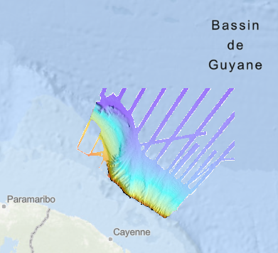
Bathymétrie de la marge guyanaise et du plateau de Démérara, au large de la Guyane (synthèse mise à jour en 2019), au pas de 250 mètres. Ce Modèle Numérique de Terrain est une compilation de données issues des campagnes GUYAPLAC, LOBESTORY, et CITHER 1. Le MNT a été produit dans le cadre du programme EXTRAPLAC pour la délimitation du plateau continental au-delà des 200 milles. Description des campagnes: - Guyaplac, 2003, R/V Atalante : source principale du MNT. Campagne financée par le MTES dans le cadre du programme EXTRAPLAC. https://doi.org/10.17600/3010050 - Lobestory, 2004, R/V L'Atalante, données en transit https://doi.org/10.17600/4010030 - Cither1, 1993, R/V L'Atalante, données en transit https://doi.org/10.17600/93000010