 Metadata catalogue
15 meter
Type of resources
Available actions
Topics
INSPIRE themes
Keywords
Contact for the resource
Provided by
Years
Formats
Representation types
Update frequencies
status
Scale
Resolution
-

Bathymetry data was acquired during R/V MARIA S. MERIAN cruise MSM44 in the northeastern Baffin Bay between 30.06.2015 and 30.07.2015. The cruise carried out multidisciplinary research in order to investigate the deglaciation history of the Greenland Ice Sheet (GIS). To research the involved ocean, cryosphere and climate processes and feedbacks and to address the complex spatial and temporal distribution patterns of the marine GIS terminations in the northeast Baffin Bay, RV MARIA S. MERIAN visited sites in the Davis Strait, the Uumannaq Trough, and the Melville Bay during expedition MSM44. The objectives were to systematically search for and map glacigenic seafloor features providing information on the maximum extend and retreat histories of ice sheets since the last glacial maximum and during the Holocene. Extensive mapping was conducted due to the fact, that several huge parts of Greenland’s coast are only insufficiently mapped or completely uncharted and thus are barely reliable in concern of navigation and interpretation towards glacigenic features of the last ice ages. CI Citation: Paul Wintersteller (seafloor-imaging@marum.de) as responsible party for bathymetry raw data ingest and approval.
-
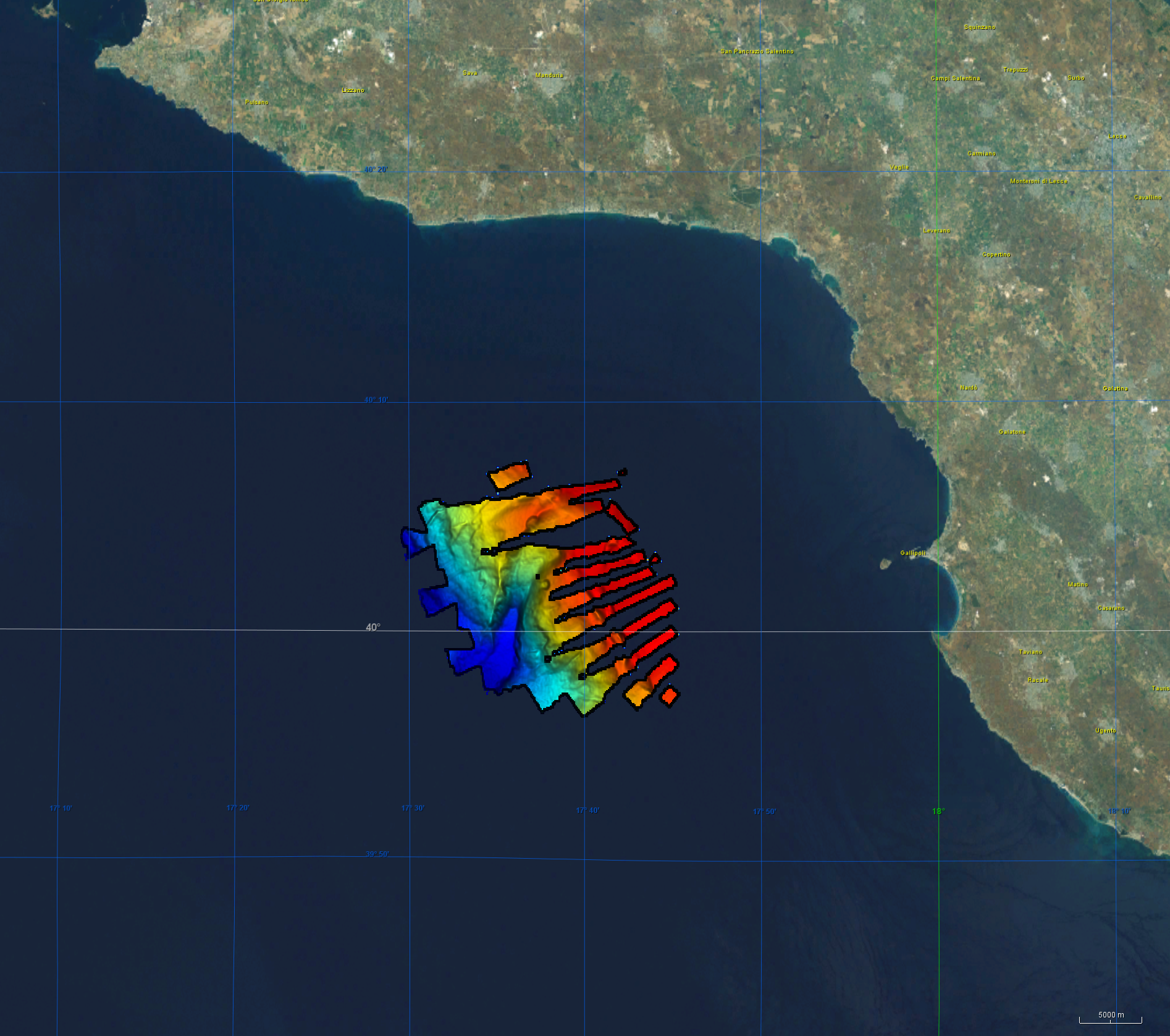
Bathymetry data was acquired during R/V Meteor cruise M144/1 in the aegean region of the Mediterranean Sea between 27.12.2017 and 18.01.2018. The cruise aimed to clarify the causal links between climate and ecosystem change on the one hand by sociocultural evolution on the other hand by climatic and environmental change that can be aligned with the archeological record. CI Citation: Paul Wintersteller (seafloor-imaging@marum.de) as responsible party for bathymetry raw data ingest and approval. Description of data source: During the M144/1 cruise, the hull-mounted KONGSBERG EM122 multibeam ecosounder (MBES) was utilized to perform bathymetric mapping in medium to deep waters. Two linear transducer arrays in a Mills Cross configuration transmit acoustic signals of a nominal sonar frequency of 12 kHz. With 432 soundings per swath, the emission cone has a dimension of max 150° across track and 1° along track. With a reception obtained from 288 beams, the actual beam footprint is 1° by 2°. Depending on the roughness of the seafloor and the water depth, the swath width on a flat bottom is maximum six times the water depth. For further information on the system, consult https://www.km.kongsberg.com/. The position and depth of the water column is estimated for each beam by using the detected two-way-travel time and the beam angle, ray-traced through the water column, utilizing a proper sound speed profile. Throughout this cruise the swath width was mainly at 120° and did not exceed 130°. Responsible person during this cruise / PI: unstated.
-
Bathymétrie de la pente du lagon de Mayotte, au pas de 15 mètres. Ce jeu de données est un Modèle Numérique de Terrain bathymétrique, issu de l'acquisition acoustique du sondeur multifaisceaux SB7150 du N/O Pourquoi Pas?. Référence verticale : Rapport de traitement : Robin BONNET, stage fin d'étude 2021, Ifremer Géosciences Marines. Traitement, calcul de différentiel et proposition de méthode de comparaison de données issues de sondeur multifaisceaux. Campagne MAYOBS, 2021. Description de la campagne : THINON Isabelle, RINNERT Emmanuel, FEUILLET Nathalie (2021) MAYOBS17 cruise, RV Pourquoi pas ?, https://doi.org/10.17600/18001983
-
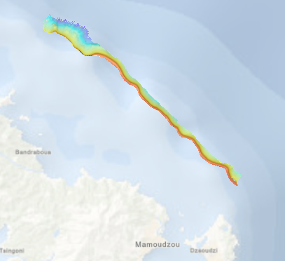
Bathymétrie de la pente du lagon, au nord-est de Mayotte (campagne MAYOBS19, 2021), au pas de 15 mètres (projection Mercator 13°S). Ce jeu de données est un Modèle Numérique de Terrain bathymétrique, issu de l'acquisition acoustique du sondeur multifaisceaux SB7111 du N/O Pourquoi Pas ?, lors de la campagne MAYOBS19. Les profondeurs sont rapportées au niveau des plus basses mer astronomiques (PBMA) au point de référence 12°30' S ; 45°39' E. Rapport de traitement : Pierre Delphine, Loubrieu Benoit (2021). Campagnes MAYOBS18-GEOFLAMME-MAYOBS19. Traitement des données multifaisceau. N/O Pourquoi Pas ? 06/04/2021 – 05/06/2021. REM/GM/CTDI. Description campagne : RINNERT Emmanuel, PAQUET Fabien, LEBAS Elodie (2021) MAYOBS19 cruise, RV Pourquoi pas ?, https://doi.org/10.17600/18001985
-
Bathymétrie du golfe du Lion, au pas de 15 mètres. Ce jeu de données est un Modèle Numérique de Terrain bathymétrique, issu de l'acquisition acoustique du sondeur multifaisceaux EM302 du N/O Le Suroît, lors du leg 1 de la campagne AM-MED-1. Rapport de traitement : Saout Johan (2015). AM-MED1/ Leg1 : traitement des données SMF. Description de la campagne : RABINEAU Marina, DROZ Laurence, ASLANIAN Daniel (2013) AM-MED-1 cruise, RV Le Suroît, https://doi.org/10.17600/18000821 Description de la mission : RABINEAU Marina, DROZ Laurence, ASLANIAN Daniel (2013) AM-MED-1 LEG1 cruise, RV Le Suroît, https://doi.org/10.17600/13020050
-
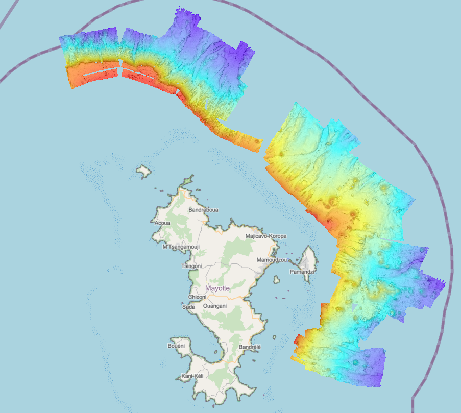
Bathymétrie de la zone de la ride, au large de Mayotte (campagne MAYOBS2, 2019), au pas de 15 mètres (projection Mercator 13°S). Ce jeu de données est un Modèle Numérique de Terrain bathymétrique, issu de l'acquisition acoustique du sondeur multifaisceau du N/O Marion Dufresne, lors de la campagne MAYOBS2, du 11 au 17 juin 2019. Les profondeurs sont rapportées au niveau des plus basses mer astronomiques (PBMA) au point de référence 12°30' S ; 45°39' E. Rapport de traitement : Guerin Charline (2019). Note technique. Campagne MAYOBS-2 (MD221). Traitement SMF. DIT.REM/GM/CTDI-20191023-CG01. Description de la campagne : JORRY Stéphan (2019) MAYOBS2 cruise, RV Marion Dufresne, https://doi.org/10.17600/18001222
-

Bathymétrie entre Antibes et Nice, en mer Méditerranée (campagne ESSAIS EM1000, 1991), au pas de 15 mètres (WGS84, projection Mercator latitude 38°N). Les données ont été acquises avec le sondeur EM300 du N/O Le Suroît, lors de la campagne ESSAIS EM1000. Référence verticale : niveau observé des mers Description de la campagne : SAUZADE Didier (1991) ESSAIS EM1000 cruise, RV Le Suroît, https://doi.org/10.17600/91003811
-
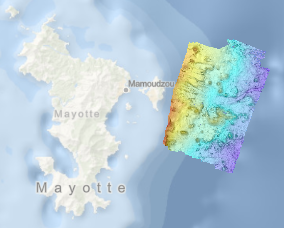
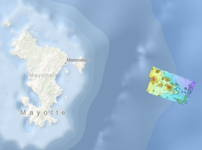
Bathymétrie de la zone proche de la côte, à l'est de Mayotte (campagne MAYOBS2, 2019), au pas de 15 mètres (projection Mercator 13°S). Ce jeu de données est un Modèle Numérique de Terrain bathymétrique, issu de l'acquisition acoustique du sondeur multifaisceau du N/O Marion Dufresne, lors de la campagne MAYOBS2, du 11 au 17 juin 2019. Les profondeurs sont rapportées au niveau des plus basses mer astronomiques (PBMA) au point de référence 12°30' S ; 45°39' E. Rapport de traitement : Guerin Charline (2019). Note technique. Campagne MAYOBS-2 (MD221). Traitement SMF. DIT.REM/GM/CTDI-20191023-CG01. Description de la campagne : JORRY Stéphan (2019) MAYOBS2 cruise, RV Marion Dufresne, https://doi.org/10.17600/18001222