 Metadata catalogue
10 meter
Type of resources
Available actions
Topics
INSPIRE themes
Keywords
Contact for the resource
Provided by
Years
Formats
Representation types
Update frequencies
status
Scale
Resolution
-
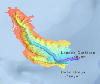
Bathymetry and seafloor variables at 10-m resolution in the Lacaze-Duthiers Canyon, below130 m depth
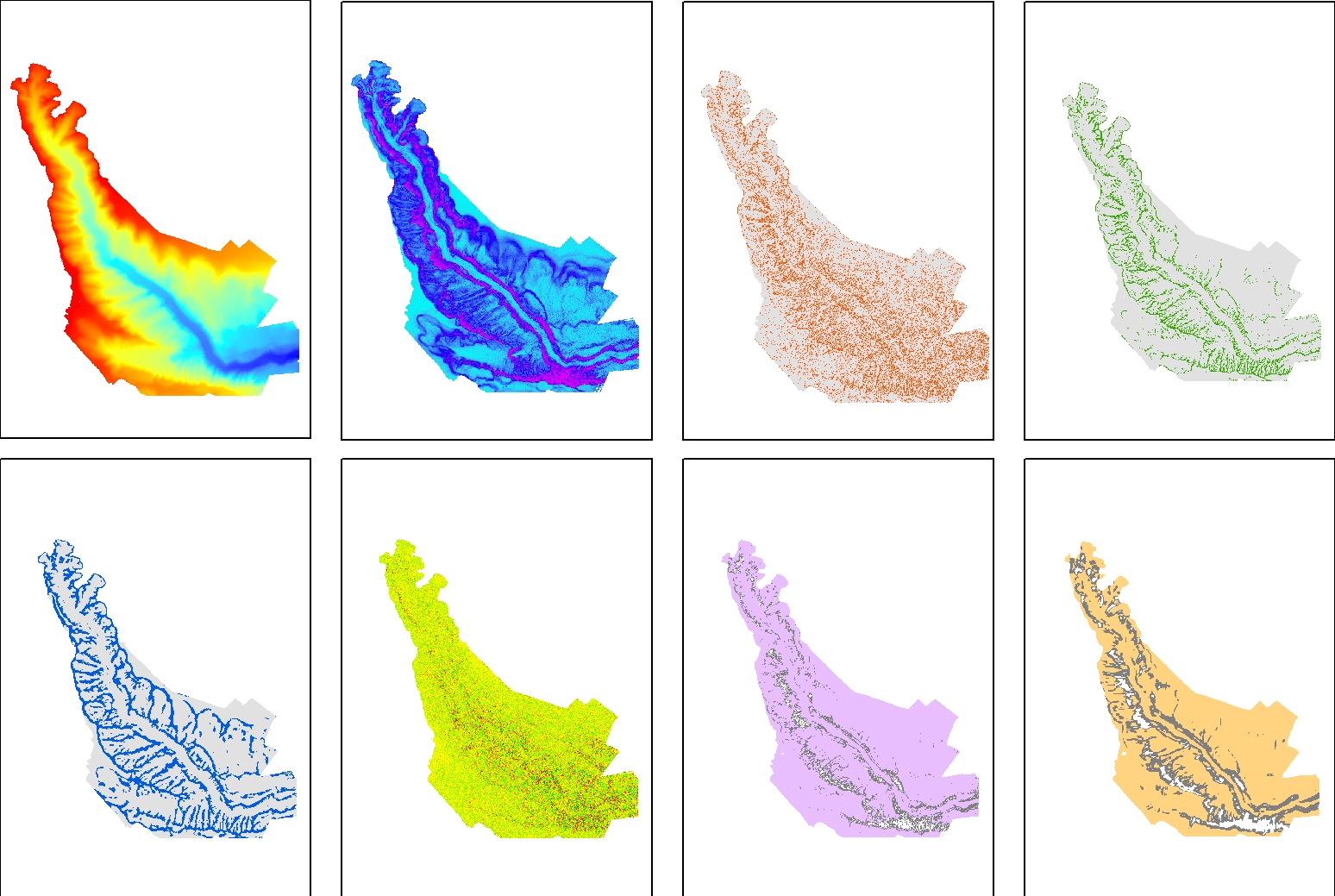
Seafloor variables were derived from the digital terrain models (DTMs) at a 10-m resolution for the entire canyon. The Lacaze-Duthiers Canyon was first delineated, and only data below 130 m depth were retained. The dataset is composed of 12 variables : Bathymetry; Slope; Aspect; Curvature; Surface area to Planar area; Vector Ruggedness Measure (VRM) computed using 9, and 25 pixels; and Bathymetric Position Index (BPI) calculated using windows of 3, 9, 25, 49, and 123 pixels. This dataset was produced to assess the probable distribution of habitats (habitat suitability modeling) for cold-water corals in the Lacaze-Duthiers Canyon at different resolutions as part of the European H2020 project REDRESS (Restoration of Deep-Sea Habitats to Rebuild European Seas, https://redress-project.eu/, Grant Agreement No. 101135492). This dataset is related to the article "Mapping and Conservation of Cold-Water Corals in the Lacaze-Duthiers Canyon for Transboundary Management", submitted to Mediterranean Marine Science by Fabri et al. in 2025.
-
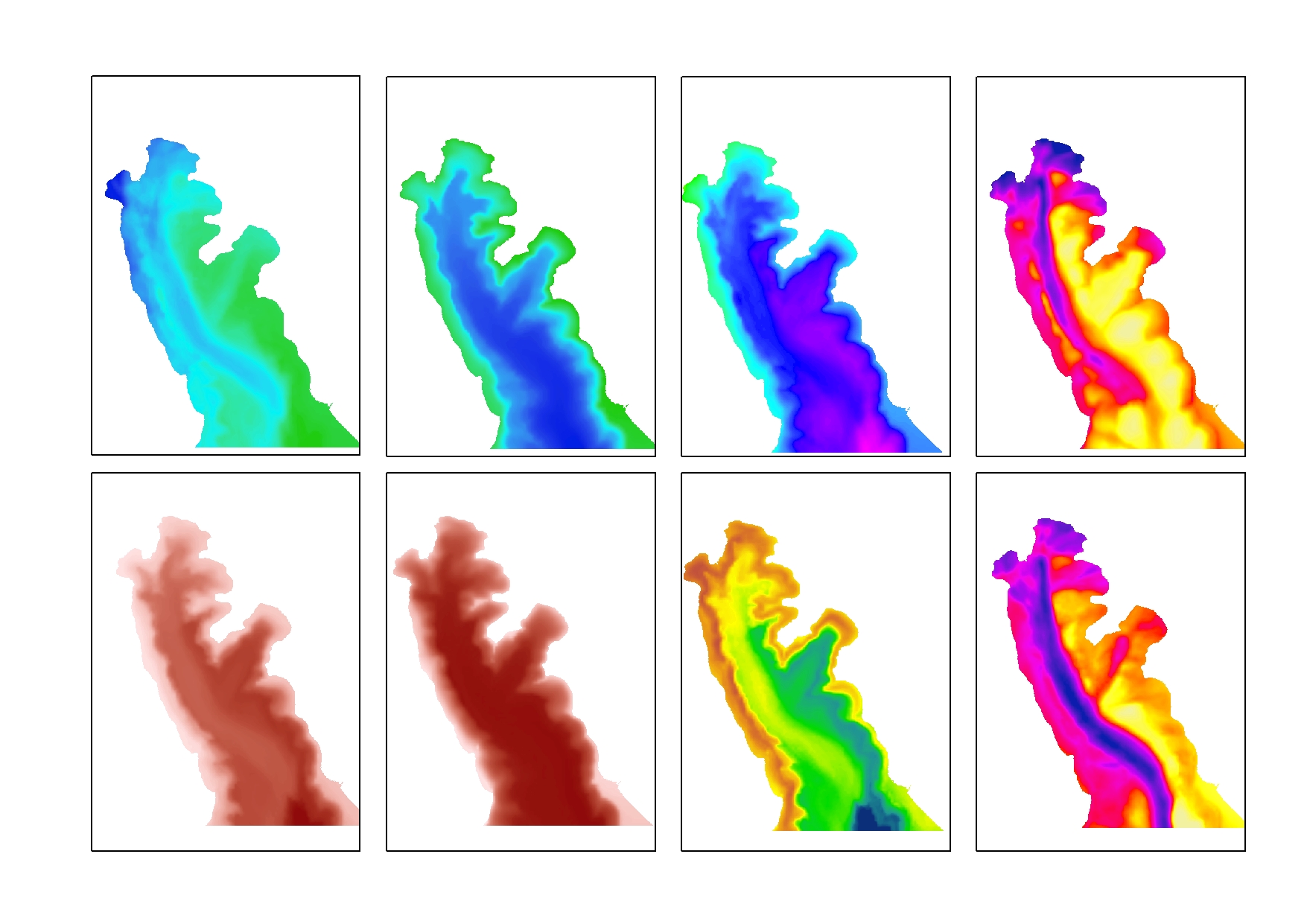
Bottom hydrodynamic variables (Temperature, Salinity, Current velocitiy) were derived from the near-seafloor hydrodynamic dataset modeled using SYMPHONIE (https://www.seanoe.org/data/00943/105472/). Extreme percentiles (1%, 99%) of bottom temperature and salinity, as well as (95%, 99%) of bottom currents were interpolated to produce rasters 5-m resolution. Additionally, salinity and temperature amplitude rasters (Ampli-T ; Ampli-S) were created by subtracting T01 from T99 and S01 from S99. The dataset is composed of eight rasters. Only data below 130 m depth were retained, focused on the Lacaze-Duthiers Canyon. This dataset was produced to assess the probable distribution of habitats (habitat suitability modeling) for cold-water corals in the Lacaze-Duthiers Canyon at different resolutions as part of the European H2020 project REDRESS (Restoration of Deep-Sea Habitats to Rebuild European Seas, https://redress-project.eu/, Grant Agreement No. 101135492). SYMPHONIE is a component of the national service SIROCCO (research infrastructure ILICO). This dataset is related to the article "Mapping and Conservation of Cold-Water Corals in the Lacaze-Duthiers Canyon for Transboundary Management", submitted to Mediterranean Marine Science by Fabri et al. in 2025.
-
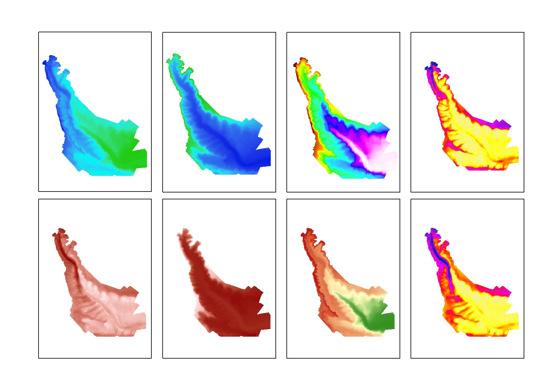
Bottom hydrodynamic variables (Temperature, Salinity, Current velocitiy) were derived from the near-seafloor hydrodynamic dataset modeled using SYMPHONIE (https://www.seanoe.org/data/00943/105472/). Extreme percentiles (1%, 99%) of bottom temperature and salinity, as well as (95%, 99%) of bottom currents were interpolated to produce rasters 10-m resolution. Additionally, salinity and temperature amplitude rasters (Ampli-T ; Ampli-S) were created by subtracting T01 from T99 and S01 from S99. The data is composed of eight rasters. Only data below 130 m depth were retained, focused on the Lacaze-Duthiers Canyon. This dataset was produced to assess the probable distribution of habitats (habitat suitability modeling) for cold-water corals in the Lacaze-Duthiers Canyon at different resolutions as part of the European H2020 project REDRESS (Restoration of Deep-Sea Habitats to Rebuild European Seas, https://redress-project.eu/, Grant Agreement No. 101135492). SYMPHONIE is a component of the national service SIROCCO (research infrastructure ILICO). This dataset is related to the article "Mapping and Conservation of Cold-Water Corals in the Lacaze-Duthiers Canyon for Transboundary Management", submitted to Mediterranean Marine Science by Fabri et al. in 2025.
-
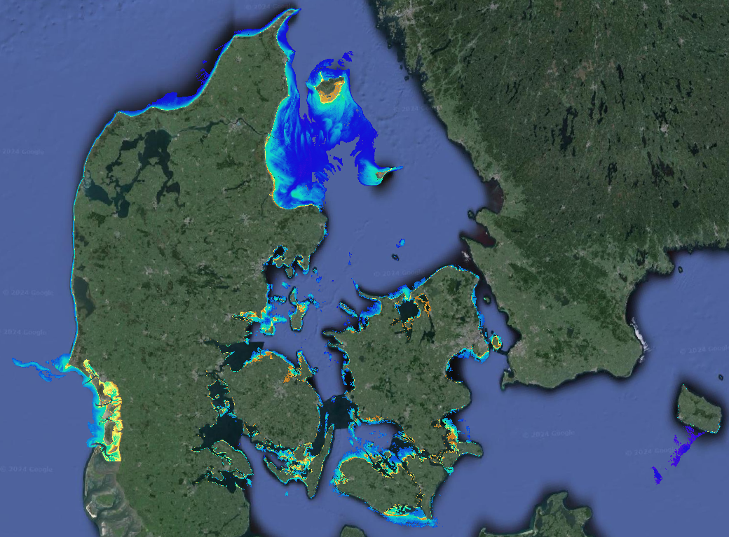
Data provides Satellite-Derived Bathymetry (SDB) data for shallow waters. The analysis is based on EOMAP’s WATCOR-X SDB software and Sentinel-2 data. The native spatial resolution of the data is 10m. Supplemental_Information: EOMAPs Satellite Derived Bathymetry (SDB) method relies on the reflected light energy which is measured at the satellite sensor in space. To calculate water depth, the sea bottom reflection must be separated from all other simultaneously measured portions of light. Other contributors of light scattered to the sensor are atmospheric molecules and aerosols, adjacent scattering from land, the water surface reflection, and light scattered and absorbed due to particular properties of water constituents and the pure water itself. The pure water itself also absorbs light in a spectrally specific manner and therefore leaves unique signatures in the signal while the light passes through the water column and returns after reflection at the sea bottom. This property is relevant to estimate water depth from optical satellite imagery. As many properties can vary over space and time, effective correction, regularization and retrieval algorithms must be applied to avoid instable results. Furthermore, multi-record analytics are part of the process and reduce noise and increase overall vertical accuracies. EOMAP developed and maintains these unique algorithms and its workflows for almost 2 decades and has developed the Watcor-X SDB software. The maximum depth the system is able to sense is related to the complex interaction of radiance of bottom material, incident sun angle and intensity, and the type and quantity of organics or sediments in the water column. As a rule-of-thumb, SDB can measure depths down to one to one point five times the Secchi Disc Depth. The SDB data are compared against Satellite-Lidar Bathymetry (SLB) tracks which have been derived out of the IceSat-2 Atlas instrument and are stored and distributed via EOMAP’s SLB database. No-data-value optically deep water: -9999
-
Bathymétrie du canyon Lacaze-Duthiers (campagne CALADU_2021), au pas de 10 mètres. Ce jeu de données est un Modèle Numérique de Terrain bathymétrique, issu de l'acquisition acoustique du sondeur multifaisceau EM304 du N/O Thalassa. Référence verticale : niveau de la mer observé (pas de correction de marée) Rapport de traitement : Gaillot Arnaud (2024). CALADU_2021. Traitement des données SMF coque et engin. Ref. ASTI-2024-331. Ifremer. Description de la campagne : FABRI Marie-Claire (2021) CALADU_2021 cruise, RV Thalassa, https://doi.org/10.17600/18001575
-

Bathymétrie au large du Rhône de Peccaïs, dans le golfe du Lion, au pas de 10 mètres. Ce jeu de données est un Modèle Numérique de Terrain bathymétrique, issu de l'acquisition acoustique du sondeur multifaisceaux EM300 du N/O Le Suroît. Référence verticale : niveau moyen des mers Description de la campagne : BERNE Serge (2002) STRATAFORM 1 cruise, RV Le Suroît, https://doi.org/10.17600/2020030
-

Bathymétrie du golfe du Lion, au pas de 10 mètres. Ce jeu de données est un Modèle Numérique de Terrain bathymétrique, issu de l'acquisition acoustique du sondeur multifaisceaux EM302 du N/O Le Suroît, lors du leg 1 de la campagne AM-MED-1. Rapport de traitement : Saout Johan (2015). AM-MED1/ Leg1 : traitement des données SMF. Description de la campagne : RABINEAU Marina, DROZ Laurence, ASLANIAN Daniel (2013) AM-MED-1 cruise, RV Le Suroît, https://doi.org/10.17600/18000821 Description de la mission : RABINEAU Marina, DROZ Laurence, ASLANIAN Daniel (2013) AM-MED-1 LEG1 cruise, RV Le Suroît, https://doi.org/10.17600/13020050
-

Bathymétrie du plateau continental du golfe du Lion, au pas de 10 mètres. Ce jeu de données est un Modèle Numérique de Terrain bathymétrique, issu de l'acquisition acoustique du sondeur multifaisceaux EM302 du N/O Le Suroît, lors du leg 2 de la campagne AM-MED-1. Rapport de traitement : Breton, C., Loubrieu, B. 2015. Campagne AMMED1. Rapport de traitement de données bathymétriques du leg 2. Description de la campagne : RABINEAU Marina, DROZ Laurence, ASLANIAN Daniel (2013) AM-MED-1 cruise, RV Le Suroît, https://doi.org/10.17600/18000821 Description de la mission : RABINEAU Marina, DROZ Laurence, ASLANIAN Daniel (2013) AM-MED-1 LEG2 cruise, RV Le Suroît, https://doi.org/10.17600/13020120
-
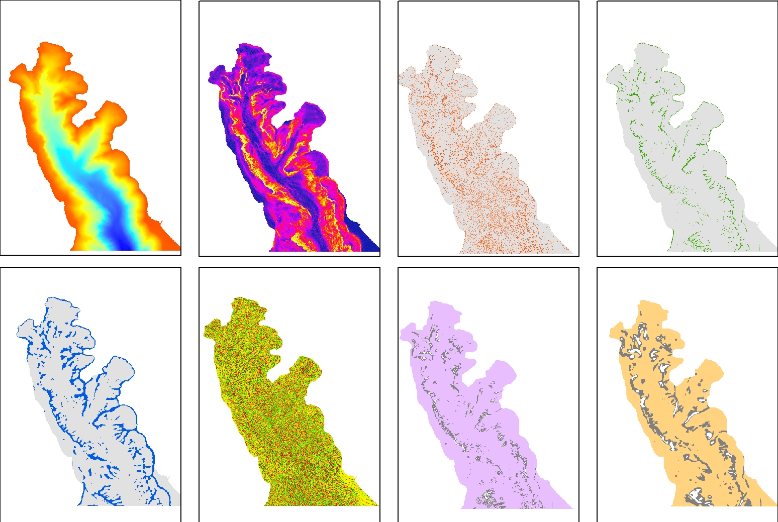
Seafloor variables were derived from the digital terrain models (DTMs) at a 5-m resolution for the entire canyon. The Lacaze-Duthiers Canyon was first delineated, and only data below 130 m depth were retained. The dataset is composed of 15 variables : Bathymetry; Slope; Aspect; Curvature; Surface area to Planar area; Vector Ruggedness Measure (VRM) computed using 9, 25 and 49 pixels; and Bathymetric Position Index (BPI) calculated using windows of 3, 9, 11, 25, 49, 81, and 250 pixels. This dataset was produced to assess the probable distribution of habitats (habitat suitability modeling) for cold-water corals in the Lacaze-Duthiers Canyon at different resolutions as part of the European H2020 project REDRESS (Restoration of Deep-Sea Habitats to Rebuild European Seas, https://redress-project.eu/, Grant Agreement No. 101135492). This dataset is related to the article "Mapping and Conservation of Cold-Water Corals in the Lacaze-Duthiers Canyon for Transboundary Management", submitted to Mediterranean Marine Science by Fabri et al. in 2025.