 Metadata catalogue
Ifremer, SM, RI French Oceanographic Fleet, F-83500 La Seyne-sur-Mer, France
Type of resources
Available actions
Topics
Keywords
Contact for the resource
Provided by
Years
Formats
-
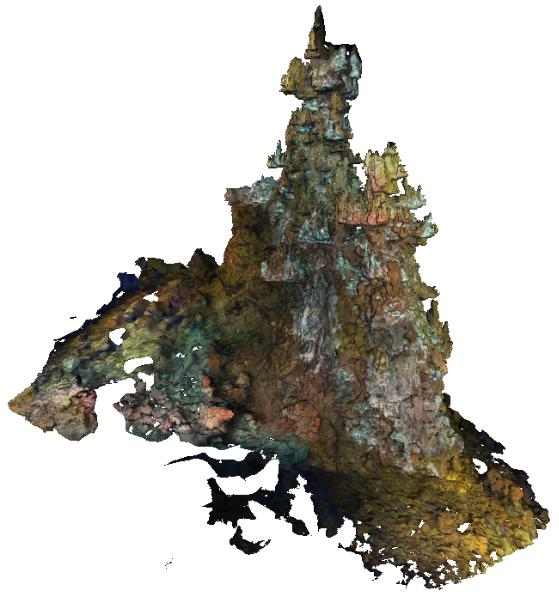
The Capelinhos hydrothermal vent site is a large edifice of 588 m² from its base. Located off axis, 1.5 km east of the central lava lake of the main Lucky Strike Hydrothermal Vent Field (mLSHVF), it is characterised by distinct geochemical and thermal conditions from the others mLSHVF edifices, with notably high iron concentrations compared to sites around the lava lake. The edifice has been surveyed with the remotely operated vehicle Victor6000 for inter-annual monitoring during the 2023 Momarsat cruise. Video transects were collected during dive 844-6 with a forward-looking camera and video sequences were used to build 3D models of the edifice using structure-from-motion techniques. A first dataset includes 2971 images extracted every 2 seconds from the videos. The images are time-stamped and linked to a navigation file, which is generated by interpolating navigation data at the corresponding timestamps. A second dataset includes a 3D textured model of the site (obj format) together with the a kml file for georeferencing. The ROV navigation file (.txt) is provided separately. Point : 37.28948183 (lat) -32.26413676 (long) -1663.487 (depth)
-

The Sintra hydrothermal vent site reconstructed in this dataset is 311.82 m². It is located in the North east of the main Lucky Strike Hydrothermal Vent Field (LSHF). The edifice has been surveyed with the remotely operated vehicle Victor6000 for inter-annual monitoring during the 2023 Momarsat cruise. Video transects were collected during dive 844-6 with a forward-looking camera and video sequences were used to build a 3D model of the edifice using structure-from-motion techniques. A first dataset includes 1561 images extracted every 2 seconds from the videos. The images are time-stamped and linked to a navigation file, which is generated by interpolating navigation data at the corresponding timestamps. A second dataset includes a 3D textured model of the site (obj format) together with the a kml file for georeferencing. The ROV navigation file (.txt) is provided separately. Point : 37.2921244612 (lat) -32.2750499167 (long) -1612.34 (depth)