 Metadata catalogue
Geological Survey of Spain (IGME)
Type of resources
Available actions
Topics
INSPIRE themes
Keywords
Contact for the resource
Provided by
Years
Formats
Representation types
Update frequencies
Service types
Scale
-
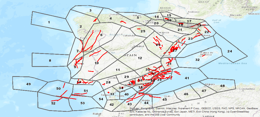
Database visualization service of seismogenic zones of the Iberian Peninsula and territories of influence for the calculation of seismic hazard in Spain (ZESIS)
-
The C factor represents the potential for water to bypass the protection provided by the overlying layers. In the pilot area, the Upper Guadiana Basin, the “C” factor shows higher reduction of protection in Campo de Montiel aquifer (in the southern) whereas in the rest of the area it shows low reduction (78%).
-
The O factor considers the protection provided to the aquifer by the physical properties and thickness of the layers above the saturated zone. In the pilot area, the Upper Guadiana Basin, the groundwater level has high variability varying from less than 1 m to more than 250 m. The lithology in the northern area is poorly permeable and higher permeability values can be found in the south. The soil texture in the northern area is predominantly silty-loam. The protection of the overlying layers estimated by “O” factor is high in 43% of the area, moderate in 29% of the area and very low in 13% of the area.
-
P factor includes the quantity of precipitation and factors which influence the rate of infiltration, i.e. frequency, temporal distribution, duration and intensity of extreme rainfall events. The mean precipitation in the Upper Guadiana Basin is between 465 and 800 mm/year.
-
I parameter represents the unsaturated zone above the water table. The values of the vadose zone materials are classified into ten classes and a rate is assigned to each class: Silt/Clay: [1] Shale: [3] Limestone: [6] Sandstone: [6] Bedded limestone, sandstone, shale: [6] Sand and gravel with significant silt and clay: [6] Metamorphic/Igneous: [4] Sand and gravel: [8] Basalt: [9] Karst limestone: [10] In the Upper Guadiana Basin pilot, the unsaturated zone is formed by poorly permeable lithologies in the northern area and higher permeability values can be found in the sourthern part.
-
R parameter represents the net recharge per unit area. The values of the recharge (mm) are classified into six classes and a rate is assigned to each class (<50 mm = [1]; 50 - 100 = [3]; 100 - 175 = [6]; 175 - 250 = [8]; 250 - 500 = [9]; >500 = [10]). In the Upper Guadiana Basin pilot, rainfall is the main source of aquifers recharge. The mean annual recharge varies between 45 and 70 mm/year.
-
A refers to the consolidated or unconsolidated medium that composes the aquifer. The different materials are classified into ten ranges and a rate is assigned to each class: Metamorphic/Igneous: [2] Weathered metamorphic/Igneous: [3] Thin bedded sandstone, Limestone: [4] Shale sequences: [6] Massive sandstone: [6] Massive limestone: [6] Sand and gravel: [8] Basalt: [9] Karst limestone: [10] In the Upper Guadiana Basin pilot, the geology is complex, including detrital and carbonated aquifers and the groundwater connectivity between the Upper Guadiana’s aquifer is also structurally complex. In the southern half of the Upper Guadiana Basin the aquifers are predominantly composed by limestones, with many karstified zones. Many areas in the central aquifer are formed by tertiary detrital materials. The northern aquifers are more heterogeneous. There are no large karstified areas and other formations of metamorphic materials can be found in these aquifers.
-
S refers to the uppermost part of the vadose zone, which is characterized by significant biological activity. The different type of soils are classified into eleven ranges and a rate is assigned to each class: Thin or absent: [10] Gravel: [10] Sand: [9] Peat: [8] Shrinking and/or aggregated clay: [7] Sandy loam: [6] Loam: [5] Silty loam: [4] Clay loam: [3] Muck: [2] Nonshrinking and nonaggregated clay: [1] The soils in the basin mainly belong to the cambisol group according to the FAO classification. It can also be found Regosol and others such as luvisol and podzol in the southeast area. The soil texture in the northern area is predominantly silty-loam, whereas the soil in the southern area is composed by peat.
-
D parameter represents the depth of the surface below the ground level where all the pore spaces are filled with water. The values of the depth to water (m) are classified into seven classes and a rate is assigned to each class (<1.5 m = [10]; 1.5 - 5 = [9]; 5 - 10 [7]; 10 - 15: [5]; 15 - 25: [3]; 25 - 50: [2]; >50 = [1]). In the Upper Guadiana Basin pilot, depth to water table is higher than 15 meters in most of the pilot area due to the intensive groundwater withdrawal since the early 1970s.
-
T parameter represents the slope of the land surface . The values of the slope (%) are classified into five classes and a rate is assigned to each class (0 - 2 m = [10]; 2 - 6 = [9]; 6 - 12 = [5]; 12 - 18 = [3]; >18 = [1]). In the Upper Guadiana Basin pilot, the land surface is predominantly flat, sloping gently over 150 km, from the northeast (elevation 730 m.a.s.l.) to the southwest (600 m.a.s.l.).