 Metadata catalogue
Geological Survey of Slovenia
Type of resources
Available actions
Topics
INSPIRE themes
Keywords
Contact for the resource
Provided by
Representation types
Update frequencies
Service types
Scale
-
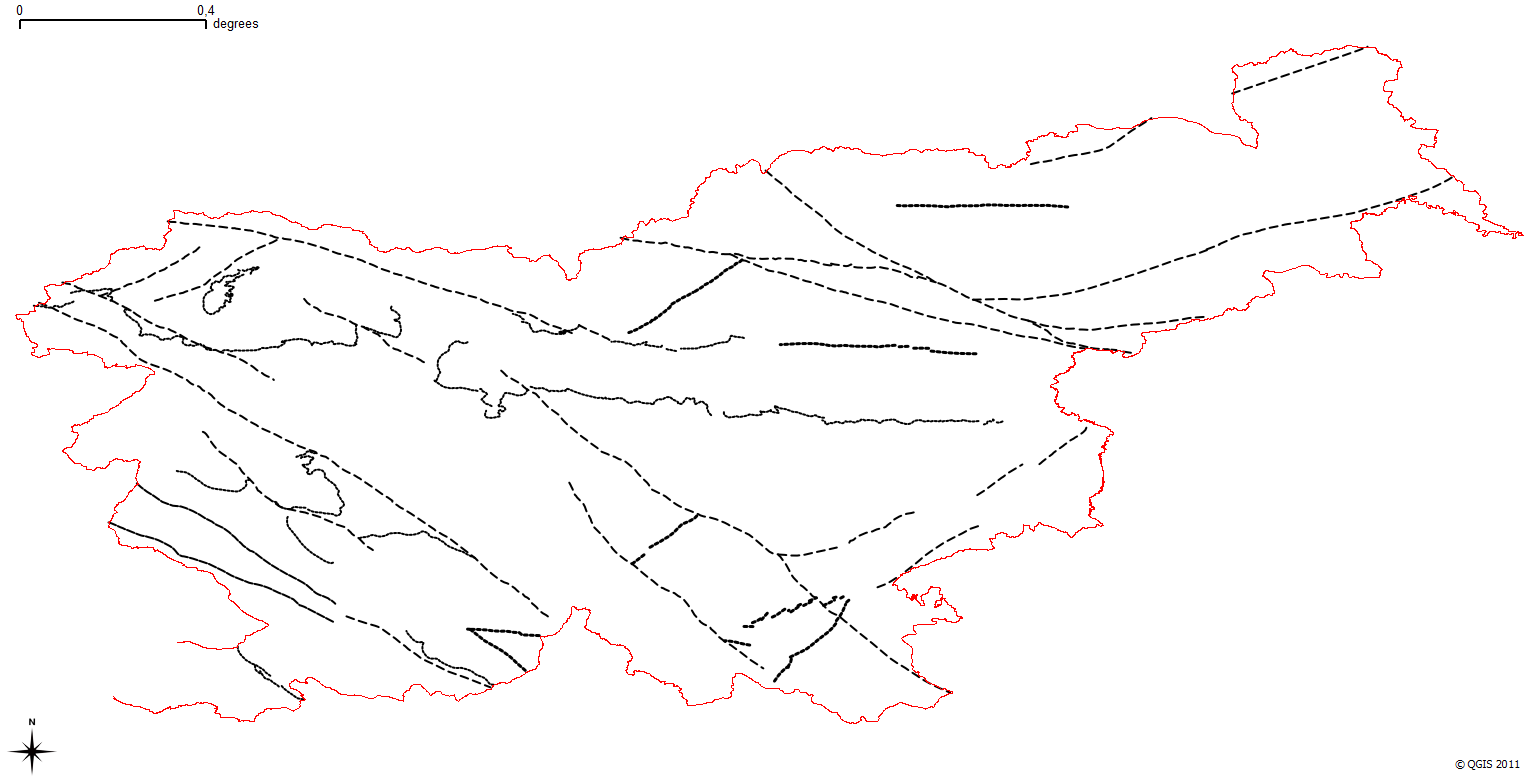
The harmonized geological map of Slovenia is a simplified version of the 1:250 000 scale Geological Map of Slovenia (Buser, 2009), which was compiled using the Basic Geological Map of Slovenia at a scale of 1: 100.000 (compiled by various authors during the 1960's to 1980's) with the addition of new information by Buser. It is primarily a lithostratigraphic map.The faults were selected for portrayal using two criteria; regional extent and tectonic importance. The map presented here was edited specifically for the purpose of the OneGeology-Europe project by M. Bavec, M. Novak, M. Poljak, M. Trajanova and D. Skaberne.
-
The harmonized geological map of Slovenia is a simplified version of the 1:250 000 scale Geological Map of Slovenia (Buser, 2009). This was compiled from the Geological Base Map of Slovenia at a scale of 1: 100.000 (contributed by various authors during the 1960's up to the 1980's) and the work was completed using new information gathered by Buser. The map is basically lithostratigraphic. The two layers incorporated in the map are lithostratigraphic units and major faults. The faults depicted on the map were selected using two criteria; regional extent and tectonic importance. The map presented here was edited specifically for the purpose of the OneGeology-Europe project by M. Bavec, M. Novak, M. Poljak, M. Trajanova and D. Skaberne.
-
The harmonized geological map of Slovenia is a simplified version of the 1:250 000 scale Geological Map of Slovenia (Buser, 2009), which was compiled using the Basic Geological Map of Slovenia at a scale of 1: 100.000 (compiled by various authors during the 1960's to 1980's) with the addition of new information by Buser. The map depicts the lithostratigraphic makeup of Slovenia . The map presented here was edited specifically for the purpose of the OneGeology-Europe project by M. Bavec, M. Novak, M. Poljak, M. Trajanova and D. Skaberne.
-
Map represents the calculated (surface) heat-flow density (HFD) in mW/m2 with topographic correction. It is made with data from 119 boreholes from the measured temperatures in the available boreholes and measured thermal conductivity on cored rock samples from the same boreholes. The pattern of the HFD isolines is affected by numerous parameters, particularly the thermal conductivity of rocks, rock permeability and fracturing, fluid content of the rocks, and all are reflected in the measured temperature gradient in the boreholes.
-
The underground geothermal conditions can be presented, irrespective of the aquifers' position, with the appropriate geothermal maps. These maps represent the expected isoterms at a depths and are derived from Geothermal maps - Expected temperatures , which are made with data from 302 boreholes. It is made on the basis of measured temperatures in accessible boreholes throughout the country. However, since the temperature field depends on the geological structure in the depths and tectonic characteristics, the course of the isotherms is a result of many influences, such as thermal conductivity of rocks, permeability and fracturing of rocks, all of which are reflected in the measured temperatures in boreholes. The distribution of boreholes, which were useful for the measurement of temperature, is very uneven and different as regard the depths.
-
The database includes basic attributes describing mineral deposits (exploitation and exploration spaces) for which the state has granted concession.
-
The underground geothermal conditions can be presented, irrespective of the aquifers' position, with the appropriate geothermal maps. This map shows the expected depths of the isotherm of 90 °C and is made with data from 191 boreholes. In a way, it is the inverse of those ordinary temperature maps showing the temperature at certain depths. It is made on the basis of measured temperatures in accessible boreholes throughout the country. However, since the temperature field depends on the geological structure in the depths and tectonic characteristics, the course contours result of many influences, such as thermal conductivity of rocks, permeability and fracturing of rocks, all of which are reflected in the measured temperatures in boreholes. The distribution of boreholes, which were useful for the measurement of temperature, is very uneven, and different as regard the depths. The map of depths to 90 °C isotherm shows a positive anomaly in the northeastern part of Slovenia. As a result of thin Earth's crust in the area and the higher conductive heat flow from the Earth's mantle, there are higher temperatures and thus are inversely smaller depths to isotherm of 90 °C.
-
The underground geothermal conditions can be presented, irrespective of the aquifers' position, with the appropriate geothermal maps. This map shows the expected depths of the isotherm of 150 °C and is made with data from 191 boreholes. In a way, it is the inverse of those ordinary temperature maps showing the temperature at certain depths. It is made on the basis of measured temperatures in accessible boreholes throughout the country. However, since the temperature field depends on the geological structure in the depths and tectonic characteristics, the course of contours results of many influences, such as thermal conductivity of rocks, permeability and fracturing of rocks, all of which are reflected in the measured temperatures in boreholes. However, the permeability and fracturing of rocks decrease with greater depths, which are for this map in the west and south and in parts of northern Slovenia quite great to this isotherm. The distribution of boreholes, which were useful for the measurement of temperature, is very uneven, and different as regard the depths. The map of depths to 150 °C isotherm shows a positive anomaly in the northeastern part of Slovenia. As a result of thin Earth's crust in the area and the higher conductive heat flow from the Earth's mantle, there are higher temperatures and thus are inversely smaller depths to the isotherm of 150 °C.
-
Geomanifestations in the Pannonian Basin area of interest. Compiled and harmonised from datasets of WP4 partners Mining and Geological Survey of Hungary, Geological Survey of Federation of Bosnia and Herzegovina, Croatian Geological Survey and Geological Survey of Slovenia.