 Metadata catalogue
Geological Survey of Israel
Type of resources
Available actions
Topics
INSPIRE themes
Keywords
Contact for the resource
Provided by
Years
Formats
Representation types
Scale
Resolution
-

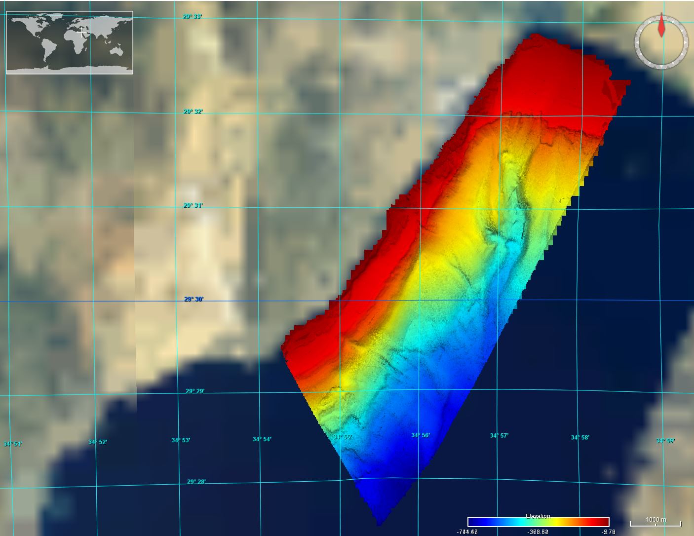
Multibeam bathymetry of Haifa Bay. Description of processed data sources: the data come from the IOLR's R/V Etziona www.ocean.org) with a Kongsberg-Simrad EM1002 (90 kHz, 111 beams). The data is the property of the Israeli Government, Ministry of National Infrastructures, which was renamed to the Ministry of Energy and Water. The original data is classified. The navigation is all with real-time corrections and is <1 m. The appropriate oceanographic measurements were made with my AML CTD as well as a Valeport SV. The analysis was all done with CARIS HIPS/SIPS. The data include another survey in deeper water with an ELAC Nautik Gmbh. SeaBeam 3050 50 kHz system, a year ago aboard the R/V Mediterranean Explorer (www.ecoocean.com) . It covered some 7,000 sq. km. from depths of ~500 to 1600 m.
-
Between 29 October and 21 November 2006, as part of the Israel National Bathymetric Survey (NBS), the IOLR’s R/V Etziona carried out a geophysical survey of the Israeli and Jordanian sectors of the northern Red Sea Gulf of ’Aqaba/Elat. Multibeam bathymetric data were collected using a Kongsberg-Simrad EM1002 system with 111 beams operating at 96 kHz. Areas that were not mapped are the northern fish cages,and areas of the coral reef preserves. Project manager: Dr. Gideon Tibor Hydrographer: Ronnie Sade
-

The "EMODnet Digital Bathymetry (DTM) - 2016" is a multilayer bathymetric product for Europe’s sea basins covering:: • the Greater North Sea, including the Kattegat and stretches of water such as Fair Isle, Cromarty, Forth, Forties, Dover, Wight, and Portland • the English Channel and Celtic Seas • Western and Central Mediterranean Sea and Ionian Sea • Bay of Biscay, Iberian coast and North-East Atlantic • Adriatic Sea • Aegean - Levantine Sea (Eastern Mediterranean) • Azores - Madeira EEZ • Canary Islands • Baltic Sea • Black Sea • Norwegian – Icelandic seas The DTM is based upon more than 7700 bathymetric survey data sets and Composite DTMs that have been gathered from 27 data providers from 18 European countries and involving 169 data originators. The gathered survey data sets can be discovered and requested for access through the Common Data Index (CDI) data discovery and access service that also contains additional European survey data sets for global waters. This discovery service makes use of SeaDataNet standards and services and have been integrated in the EMODnet portal (https://emodnet.ec.europa.eu/en/bathymetry#bathymetry-services ). The Composite DTMs are described using the Sextant Catalogue Service that makes also use of SeaDataNet standards and services. Their metadata can retrieved through interrogating the Source Reference map in the Central Map Viewing service (https://emodnet.ec.europa.eu/geoviewer/ ). In addition, the EMODnet Map Viewer gives users wide functionality for viewing and downloading the EMODnet digital bathymetry such as: • water depth (refering to the Lowest Astronomical Tide Datum - LAT) in gridded form on a DTM grid of 1/8 * 1/8 arc minute of longitude and latitude (ca 230 * 230 meters) • option to view depth parameters of individual DTM cells and references to source data • option to download DTM in 16 tiles in different formats: EMO, EMO (without GEBCO data), ESRI ASCII, ESRI ASCII Mean Sea Level, XYZ, NetCDF (CF), RGB GeoTiff and SD • layer with a number of high resolution DTMs for coastal regions • layer with wrecks from the UKHO Wrecks database. The NetCDF (CF) DTM files are fit for use in a special 3D Viewer software package which is based on the existing open source NASA World Wind JSK application. It has been developed in the frame of the EU FP7 Geo-Seas project (another sibling of SeaDataNet for marine geological and geophysical data) and is freely available. The 3D viewer also supports the ingestion of WMS overlay maps. The SD files can also be used for 3D viewing by means of the freely available iView4De(Fledermaus) software. The original datasets themselves are not distributed but described in the metadata services, giving clear information about the background survey data used for the DTM, their access restrictions, originators and distributors and facilitating requests by users to originator.
-
The "EMODnet Digital Bathymetry (DTM) - 2016" is a multilayer bathymetric product for Europe’s sea basins covering:: • the Greater North Sea, including the Kattegat and stretches of water such as Fair Isle, Cromarty, Forth, Forties, Dover, Wight, and Portland • the English Channel and Celtic Seas • Western and Central Mediterranean Sea and Ionian Sea • Bay of Biscay, Iberian coast and North-East Atlantic • Adriatic Sea • Aegean - Levantine Sea (Eastern Mediterranean) • Azores - Madeira EEZ • Canary Islands • Baltic Sea • Black Sea • Norwegian – Icelandic seas The DTM is based upon more than 7700 bathymetric survey data sets and Composite DTMs that have been gathered from 27 data providers from 18 European countries and involving 169 data originators. The gathered survey data sets can be discovered and requested for access through the Common Data Index (CDI) data discovery and access service that also contains additional European survey data sets for global waters. This discovery service makes use of SeaDataNet standards and services and have been integrated in the EMODnet portal (https://emodnet.ec.europa.eu/en/bathymetry#bathymetry-services ). The Composite DTMs are described using the Sextant Catalogue Service that makes also use of SeaDataNet standards and services. Their metadata can retrieved through interrogating the Source Reference map in the Central Map Viewing service (https://emodnet.ec.europa.eu/geoviewer/ ). In addition, the EMODnet Map Viewer gives users wide functionality for viewing and downloading the EMODnet digital bathymetry such as: • water depth (refering to the Lowest Astronomical Tide Datum - LAT) in gridded form on a DTM grid of 1/8 * 1/8 arc minute of longitude and latitude (ca 230 * 230 meters) • option to view depth parameters of individual DTM cells and references to source data • option to download DTM in 16 tiles in different formats: EMO, EMO (without GEBCO data), ESRI ASCII, ESRI ASCII Mean Sea Level, XYZ, NetCDF (CF), RGB GeoTiff and SD • layer with a number of high resolution DTMs for coastal regions • layer with wrecks from the UKHO Wrecks database. The NetCDF (CF) DTM files are fit for use in a special 3D Viewer software package which is based on the existing open source NASA World Wind JSK application. It has been developed in the frame of the EU FP7 Geo-Seas project (another sibling of SeaDataNet for marine geological and geophysical data) and is freely available. The 3D viewer also supports the ingestion of WMS overlay maps. The SD files can also be used for 3D viewing by means of the freely available iView4De(Fledermaus) software. The original datasets themselves are not distributed but described in the metadata services, giving clear information about the background survey data used for the DTM, their access restrictions, originators and distributors and facilitating requests by users to originator.