 Metadata catalogue
European Environment Agency
Type of resources
Available actions
Topics
INSPIRE themes
Keywords
Contact for the resource
Provided by
Years
Formats
Representation types
Update frequencies
Scale
Resolution
-
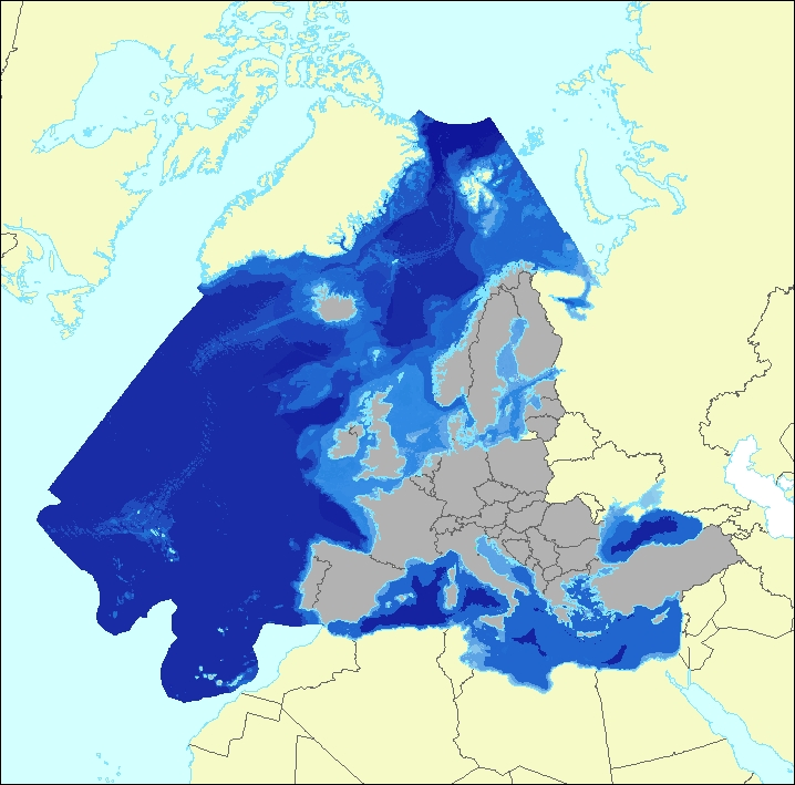
The data set aims to contribute to a better biological characterization of European marine ecosystems. As such it represents probabilities of EUNIS (EUropean Nature Information System) habitat presence at Level 3 for marine habitats including information on sea ice coverage (this corresponds to EUNIS level 2 for terrestrial habitats). The map combines spatially explicit data on marine bathymetry and sea-bed with non-spatially referenced habitat information of the EUNIS classification. The objective of the data set produced by EEA and its Topic Centre ETC/ULS is to improve the biological description of marine based ecosystem types and their spatial distribution. The work supports Target 2 Action 5 of the implementation of the EU Biodiversity Strategy to 2020, established to achieve the Aichi targets of the Convention of Biological Diversity (CBD). It further addresses the MAES process (Mapping and Assessing of Ecosystems and their Services). The data set represents 2 classes of the MAES classification level 3, namely “Marine inlets and transitional waters” and “Marine”. The dataset comprises the following information: • Sea region (1 – Arctic, 2 – Atlantic, 3 – Baltic, 4 – Mediterranean, 5 – Black Sea) • Sea zone (1 – Littoral, 2 – Infralittoral, 3 – Circalittoral, 4 – Offshore circalittoral, 5 – Upper bathyal, 6 – Lower bathyal, 7 – Abyssal,8 - Coastal Lagoons, 9 - Coastal Lagoons) • Substrate (0 – undetermined substrate, 1 – rock and biogenic, 3 – coarse sediment, 4 – mixed sediment, 5 – sand, 6 – mud) • Sea ice coverage (0 – no sea ice presence, 1 – seasonal sea ice presence, 2 – perennial sea ice presence)
-

This vector dataset represents the benthic broad habitat types in Europe Seas potentially affected by the ship wakes. When navigating, the propellers of ships generate a turbulent mixing of the water that can produce sediment re-suspension in soft bottoms of shallow areas. This can increase the turbidity in those areas, affecting the seafloor organisms (especially those that are directly dependent on light, such as aquatic plants). It may also contribute to an increase of the the eutrophication level of the ecosystem (since the turbid waters may become warmer, which may turn into a reduction of dissolved oxygen in water). Finally, turbidity can produce an increase in the inputs of contaminants and microbial pathogens, since those can become attached to the suspended solids. The dataset has been prepared in the context of the development of the first European Maritime Transport Environmental Report (https://www.eea.europa.eu/publications/maritime-transport).
-
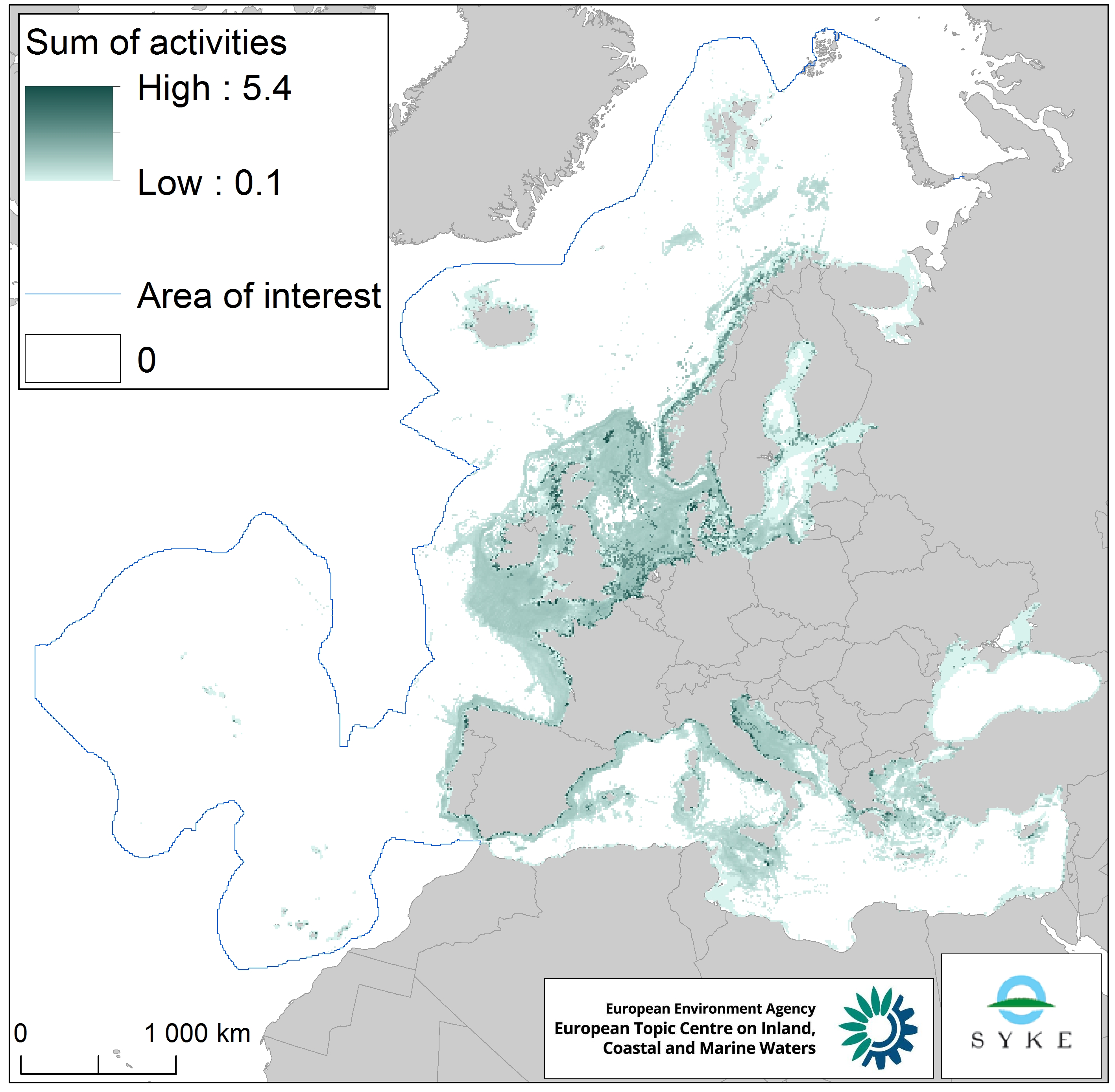
This raster dataset represents physical disturbance to the seabed in the European seas. Several human activities disturb the seabed either directly or indirectly. Alteration of benthic living conditions as a result of increased sedimentation or attenuation of light penetration, abrasion of the seabed and exploitation of benthic biota, temporarily disturb the benthic habitat quality. The dataset is an aggregation of several different human activities that cause physical disturbance to the seabed: aquaculture, demersal fishing, dredging and dumping of dredged material, oil and gas rigs, offshore installations, ports, sand and gravel extraction, shellfish mariculture, shipping in shallow waters and windfarms. The resulting dataset is a raster (10km grid cell) derived from EMODnet, MED-IAMER, JRC-STECF, OSPAR, HELCOM and 4C Offshore datasets, and with reference temporal coverage from 2012 to 2017. This dataset has been prepared for the calculation of the combined effect index, produced for the ETC/ICM Report 4/2019 "Multiple pressures and their combined effects in Europe's seas" available on: https://www.eionet.europa.eu/etcs/etc-icm/etc-icm-report-4-2019-multiple-pressures-and-their-combined-effects-in-europes-seas-1.
-
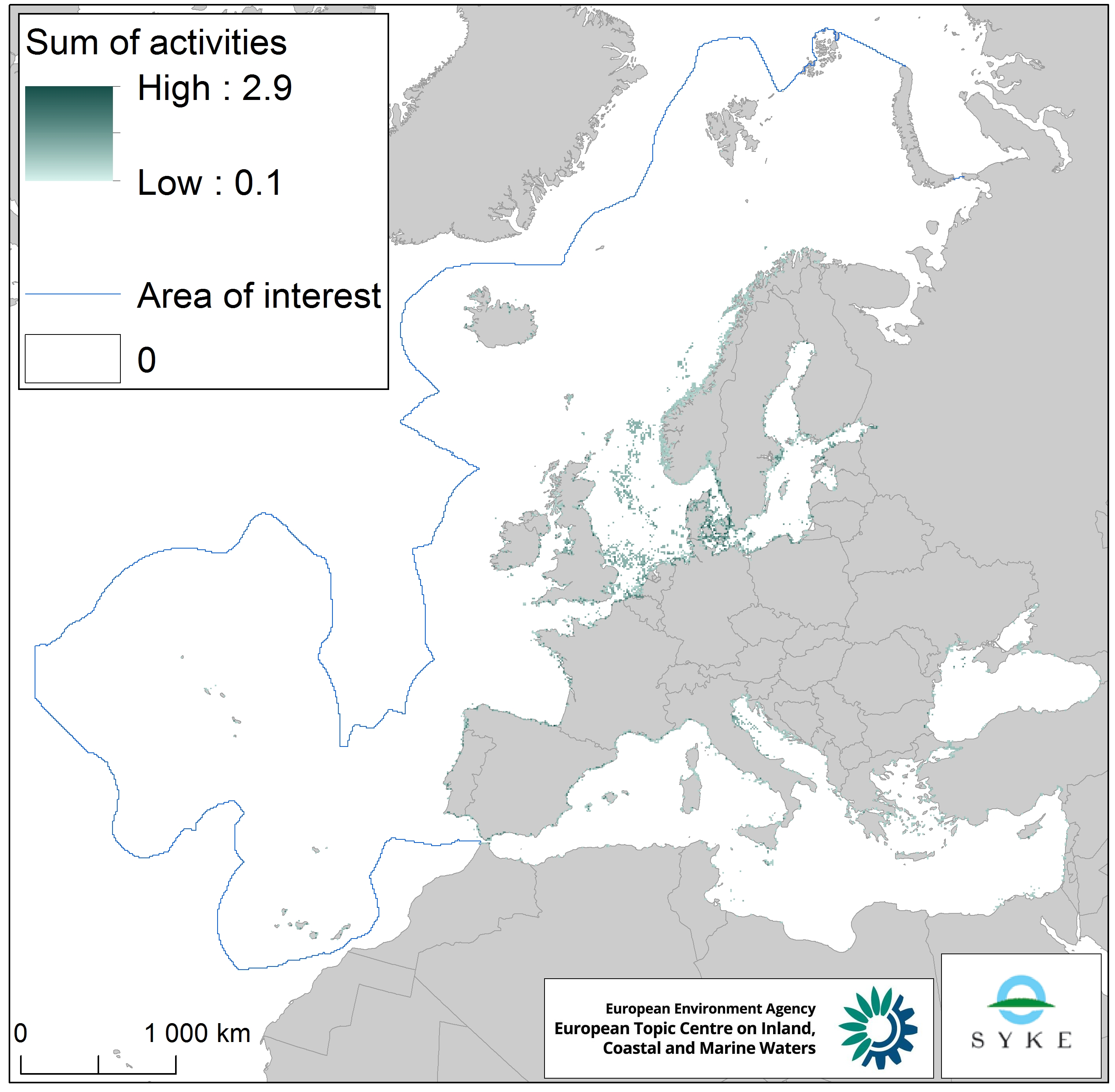
This raster dataset represents the physical loss of the seabed in the European seas. Physical habitat loss is an extreme pressure on the marine ecosystem which was defined to include all impacts on the seabed which take more than 12 years to recover, a time span influencing even long living marine mammals and seabirds. Habitat is lost if its substrate, morphology or topography is permanently altered. The dataset is an aggregation of several different human activities that cause physical loss in the seabed: dredging and dumping of dredged material, oil and gas rigs, offshore installations, ports, sand and gravel extraction and windfarms. The resulting dataset is a raster (10km grid cell) derived from EMODnet, MED-IAMER and 4C Offshore datasets and with temporal reference from 2012 to 2017. Higher values mean more loss causing activity in the area. Due to its resolution, loss causing activity in a cell does not usually mean that all the seabed habitat in the area is lost. This dataset has been prepared for the calculation of the combined effect index, produced for the ETC/ICM Report 4/2019 "Multiple pressures and their combined effects in Europe's seas" available on: https://www.eionet.europa.eu/etcs/etc-icm/etc-icm-report-4-2019-multiple-pressures-and-their-combined-effects-in-europes-seas-1.
-
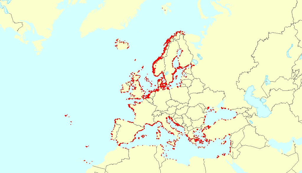
This vector dataset represents the benthic broad habitat types in Europe seas potentially affected by anchoring. The anchoring of vessels can produce damages to the seafloor and the loss of the habitat where it happens. It takes place in shallow waters, close to ports, where vessels have to wait for a spot in the port so they can load or offload (since ports have a limited amount of dockage). The anchoring areas allow vessels to safely anchor in protection from bad weather or other circumstances. The type of alterations to the habitats resulting from anchoring depend mainly on the dimensions and type of the anchor, as well as its movement resulting from the movement of the vessel due to currents or waves, which can increase the adverse effects. The dataset has been prepared in the context of the development of the first European Maritime Transport Environmental Report (to be published as an EMSA-EEA report in 2021).
-

Corine Land Cover (CLC) 2018 and CLC change 2012-2018 are two of the datasets produced within the frame of the Initial Operations of the Copernicus programme (the European Earth monitoring programme previously known as GMES) on land monitoring.Corine Land Cover (CLC) provides consistent information on land cover and land cover changes across Europe. This inventory was initiated in 1985 (reference year 1990) and established a time series of land cover information with updates in 2000 and 2006 being the last one the 2012 reference year.CLC products are based on photointerpretation of satellite images by national teams of participating countries - the EEA member and cooperating countries ��� following a standard methodology and nomenclature with the following base parameters: 44 classes in the hierarchical three level Corine nomenclature; minimum mapping unit (MMU) for status layers is 25 hectares; minimum width of linear elements is 100 metres; minimum mapping unit (MMU) for Land Cover Changes (LCC) for the change layers is 5 hectares. The resulting national land cover inventories are further integrated into a seamless land cover map of Europe.Land cover and land use (LCLU) information is important not only for land change research, but also more broadly for the monitoring of environmental change, policy support, the creation of environmental indicators and reporting. CLC datasets provide important datasets supporting the implementation of key priority areas of the Environment Action Programmes of the European Union as protecting ecosystems, halting the loss of biological diversity, tracking the impacts of climate change, assessing developments in agriculture and implementing the EU Water Framework Directive, among others.More about the Corine Land Cover (CLC) and Copernicus land monitoring data in general can be found at http://land.copernicus.eu/.
-

Inventaire biophysique de l'occupation des sols en 2006 en 50 postes. CORINE Land Cover est une base de données d’occupation des sols produite dans le cadre du programme européen d’observation de la Terre Copernicus. Cet inventaire biophysique de l’occupation des terres fournit une information géographique de référence pour 39 États européens. La continuité du programme et la diffusion des données CORINE Land Cover sont pilotées par l'Agence européenne pour l'environnement. Le producteur pour la France est le Service de la donnée et des études statistiques du ministère chargé de l'écologie. L'utilisation de cette base de données permet des applications variées adaptées aux problématiques de l'environnement et à celles de l'aménagement du territoire : production cartographique, exploitation à des fins statistiques ou bien encore analyses géographiques en combinaison avec d'autres bases de données. Outil de connaissance et d'analyse, CORINE Land Cover apporte également une aide à la décision comme instrument de suivi, de surveillance et de gestion de l'environnement, des milieux naturels et de l'aménagement de l'espace. La base de données CORINE Land Cover DOM 2006 a été réalisée à partir d'images satellitaires prises entre 2005 et 2008 et de données d'appui.
-

Raster au pas de 25m de l'inventaire biophysique de l'occupation des sols en 2006 en 44 postes. CORINE Land Cover est une base de données d’occupation des sols produite dans le cadre du programme européen d’observation de la Terre Copernicus. Cet inventaire biophysique de l’occupation des terres fournit une information géographique de référence pour 39 États européens. La continuité du programme et la diffusion des données CORINE Land Cover sont pilotées par l'Agence européenne pour l'environnement. Le producteur pour la France est le Service de la donnée et des études statistiques du ministère chargé de l'écologie. L'utilisation de cette base de données permet des applications variées adaptées aux problématiques de l'environnement et à celles de l'aménagement du territoire : production cartographique, exploitation à des fins statistiques ou bien encore analyses géographiques en combinaison avec d'autres bases de données. Outil de connaissance et d'analyse, CORINE Land Cover apporte également une aide à la décision comme instrument de suivi, de surveillance et de gestion de l'environnement, des milieux naturels et plus généralement de l'aménagement de l'espace. La base de données CORINE Land Cover 2006, dite CLC 2006, a été réalisée à partir de CLC 2000 révisée et de la base des changements 2000-2006.
-

Inventaire biophysique du changement d'occupation des sols entre 2000 et 2006 suivant la nomenclature CORINE Land Cover en 44 postes. CORINE Land Cover est une base de données d’occupation des sols produite dans le cadre du programme européen d’observation de la Terre Copernicus. Cet inventaire biophysique de l’occupation des terres fournit une information géographique de référence pour 39 États européens. La continuité du programme et la diffusion des données CORINE Land Cover sont pilotées par l'Agence européenne pour l'environnement. Le producteur pour la France est le Service de la donnée et des études statistiques du ministère chargé de l'écologie. L'utilisation de cette base de données permet des applications variées adaptées aux problématiques de l'environnement et à celles de l'aménagement du territoire : production cartographique, exploitation à des fins statistiques ou bien encore analyses géographiques en combinaison avec d'autres bases de données. Outil de connaissance et d'analyse, CORINE Land Cover apporte également une aide à la décision comme instrument de suivi, de surveillance et de gestion de l'environnement, des milieux naturels et plus généralement de l'aménagement de l'espace. La base des changements CORINE Land Cover 2000-2006, a été réalisée à partir d'images satellitaires des années 2000 et 2006 et de données d'appui.
-

Les couches haute résolution sont des couches thématiques d’occupation des sols, produites par le service Territoire du programme européen d'observation de la Terre Copernicus. Ce programme est coordonné par la Commission européenne et associe l’Agence spatiale européenne, l’Agence européenne pour l’environnement ainsi que les États membres. Ces données sont produites automatiquement à partir d’images satellite. Elles sont ensuite vérifiées puis améliorées manuellement. La production et la diffusion de ces couches haute résolution sont pilotées par l'Agence européenne pour l'environnement. Pour la France, le Service de la donnée et des études statistiques du ministère chargé de l’écologie a la responsabilité des vérifications et des améliorations de ces produits. Le type de forêt cartographie la distinction feuillus ou résineux majoritairement présents dans les pixels, avec un taux de couvert arboré de plus de 10%. Ce produit permet d’approcher le plus possible des forêts au sens de la définition de l’Organisation des Nations unies pour l'alimentation et l'agriculture (FAO). La surface minimale cartographiée est de 0,52 ha, ce qui correspond à un groupement de 13 pixels. Cette couche est accompagnée d’une couche support permettant de distinguer les groupements d’arbres en milieu urbain et agricole pour ainsi isoler les forêts. Les valeurs cartographiées sont : - 0 : Zone non-arborée - 1 : Forêt de feuillus - 2 : Forêt de conifères - 254 : Inclassable (nuage, donnée satellite indisponible, ombre ou neige) - 255 : En dehors de la zone d'étude Ces données haute résolution peuvent être utilisées indépendamment ou en complément de CORINE Land Cover. En effet, CLC permet de cartographier des polygones homogènes d’occupation des sols tels que du tissu urbain discontinu et des zones industrielles ou commerciales. Les couches haute résolution permettent alors d’apporter une nouvelle information pour chacune de ces zones, en précisant leur degré d’imperméabilisation, leur taux de couvert arboré, etc.