 Metadata catalogue
CNRS, France
Type of resources
Available actions
Topics
Keywords
Contact for the resource
Provided by
Years
Formats
-
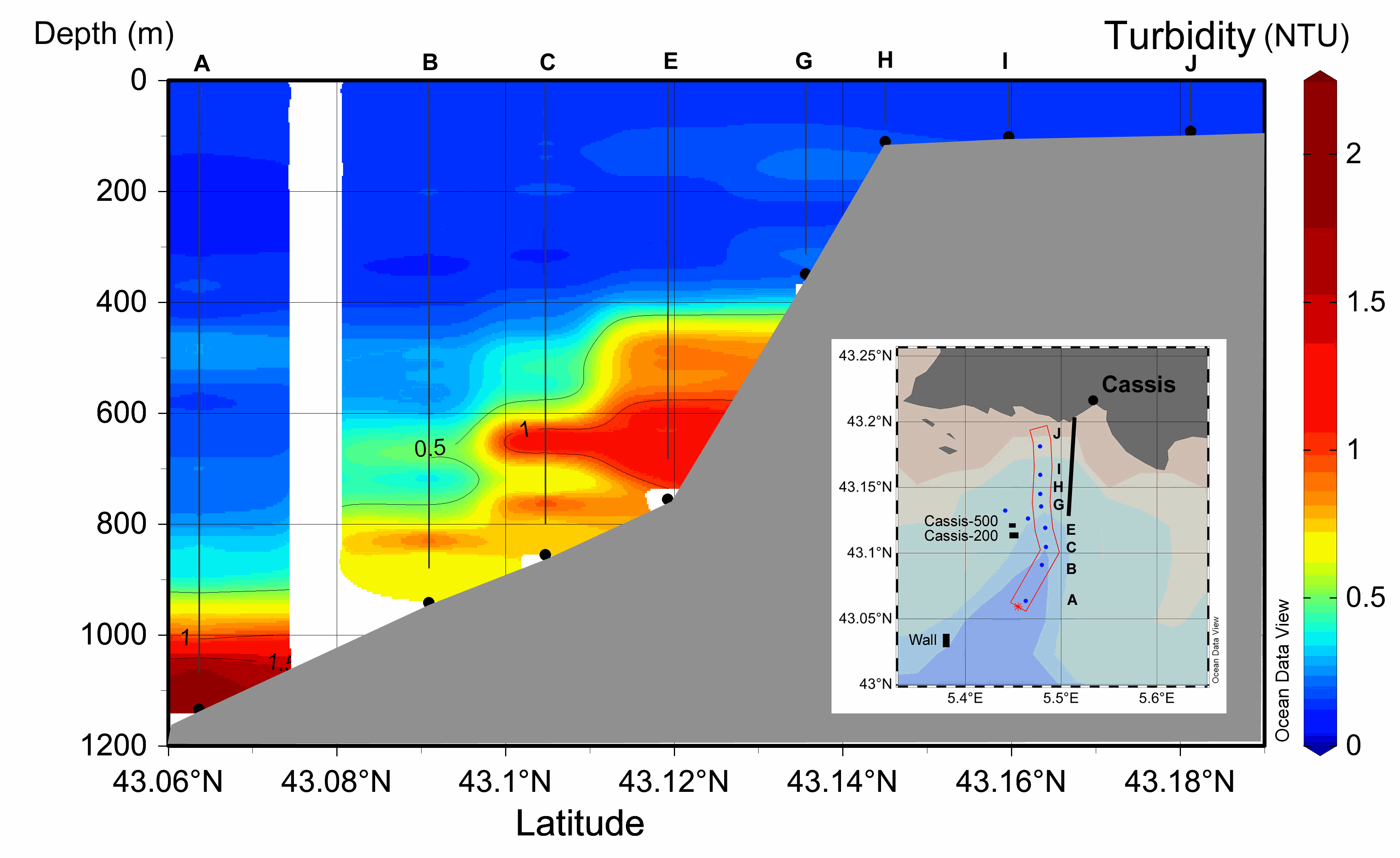
M&M - Turbidity and Suspended Sediment Concentration (SSC) An autonomous optical backscatter sensor (NKE STBD 1200) was installed on the CTD probe in 2014 during the BATHYCOR1 cruise in order to collect ten vertical turbidity profiles along the canyon axis (23th August 2014) (Fig. 1, Table 2). The profiles had to be interrupted at an average altitude of 40 to 70 mab (m above the bottom) for safety issues. The sensor was previously calibrated with Formazin as recommended by NKE marine electronics (www.nke-marine-electronics.com). The results are given in Nephelometric Turbidity Units (NTU). In order to link the NTU values to the Suspended Sediment Concentration we built a calibration curve of our sensor using bottom sediment that had been previously sampled with a push core (CT9) during ROV dive 407-11, cruise ESSROV2010 (Fontanier et al., 2012). Particle grain sizes were analyzed using laser diffraction and median grain size (D50) was 11 µm, although some particles were as large as 150 µm (see (Fontanier et al., 2012) - figure 2D). We first measured the turbidity in a 10-liter container of distilled water in which we added NaCl to obtain a salinity concentration of 38.4 g/l. We checked the concordance with a laboratory turbidimeter (Hatch 2100n IS - Iso Method 7027) to confirm the starting point (0.04 NTU). Then we progressively added a known quantity of particles in the container of salty distilled water. After each addition of particles, the water was mixed and left for 30 seconds before recording the turbidity every second for 5 minutes. We tried to keep a uniformly mixed suspension with no sediment settling but failed to prevent large particles from sinking to the bottom of the container. We then calculated the mean of the recorded turbidity in NTU for each known concentration of particles. This allowed building a calibration curve, starting from 0.04 NTU to 3 NTU, which corresponded to the range of our in situ values (online supp. mat. Fig. A1). Results - Turbidity and Suspended Sediment Concentration (SSC) The ten vertical turbidity profiles (NKE STBD 1200) collected at the CTD stations in the canyon axis show turbidity values ranging from 0.15 NTU on the shelf and in the surface layer to 2.2 NTU at the bottom of the canyon exit ; Turbidity values were very low above 300 m depth (<0.2 NTU) on the whole set of profiles (on the shelf, flanks and canyon axis) while the stations located downstream of the bauxite residue effluent in the canyon axis (Stations A, B, C, D, E) displayed maximum turbidity in the lower layer. Maximum turbidity values were measured above the bottom at the deepest station (A), exceeding 2 NTU at the canyon exit. However, the maximum particle load does not always lie just above the bottom: at stations B and C there was an intermediate maximum between 600 and 700 m, and to a lesser extent at ~500 m at station A. The turbid layer was thicker closer to the pipeline effluent. As the effluent is a mixture of particles of different sizes in freshwater, it is expected that downstream it generates several layers according to water density and particle size. The east-west orientation of the bathymetry around stations C, E, G might also contribute to the dispersion of the particles (cross-axis current), as shown by the multi-layered turbidity profile at station K (bottom depth 770 m; not shown). Thus the coral colonies at Cassis-500 are impacted by the turbidity of the red mud. According to the calibration of our sensor, we roughly correlated a turbidity value of 1 NTU to an SSC=0.6 mg/l, and the maximum measurement of around 2.5 NTU to an SSC=2 mg/l.
-
During the SARDINIA experiment, CHIRP profiles, bathymetry data, three coincident MCS reflection and wide-angle seismic profiles, and one single MCS reflection profile were collected on the West Sardinia margin. The MCS reflection data was acquired using a 4.5 km 360-trace digital streamer and a tuned airgun array of 8260 cubic inches, which was towed at a depth of 18-28 m. A total of 48 ocean bottom seismometers/hydrophones (OBS/OBH) from Ifremer, University of Brest, and Geomar Kiel were deployed on the West Sardinia margin, spaced every 7 nmi (~13 km). In five locations, three OBS were deployed at the same place to ensure the collection of data. The airgun array consists of 16 airguns ranging from 100 cubic inch G-guns to 16 L Bolt airguns, with main frequencies centered around 10-15 Hz. The airguns were tuned to the first bubble, to enhance low frequencies and ensure deep penetration. The shot interval was 60 s at an average speed of 5 knots, which translates to a trace spacing of about 140-150 m. The sample rate was 8 ms for the micrOBS, 5 ms for the Geomar, and 4 ms for the OldOBS. A total of 3573 shots (profile GH: 1130, profile G2H2: 1214) were fired by the air gun array. Profiles GH and G2H2, which are 160 and 200 km long transects, respectively cross the West Sardinia margin from the continental shelf to the “atypical” oceanic crust. Twenty-one ocean bottom seismometers (OBS) were deployed on the G2H2 profile, whereas sixteen were deployed on the GH profile. Additionally, the shots on this profile were recorded by eight land seismic stations (OSIRIS stations from the University of Brest and Geosciences Azur) that extended the marine profile ~150 km onshore. For the two profiles only 33 instruments were used in the wide-angle modeling, since four instruments (OBSS06, 18a, 30a, and 30c) did not record properly. We propose here the velocity models (v.in files) of the 2 main profiles located on the West sardinian margin, Profile K7L2, located on the shelf and parallel to the margin, is not presented since most of the deep arrivals are masked by the presence of sea-bottom multiples, preventing an accurate wide-angle model.
-

During the SARDINIA experiment, three coincident MCS reflection and wide-angle seismic profiles, sub-bottom high resolution (CHIRP) profiles, and bathymetry data were collected on the Gulf of Lion margin. The seismic reflection data were acquired using a 4.5 km, 360 trace digital streamer and a tuned airgun array of 8260 in3, towed at a depth of 18-28 m. A total of 57 ocean bottom seismometer/ hydrophones (OBS/OBH) from Ifremer, University of Brest, and Geomar Kiel were deployed in the Gulf of Lion, spaced every 7 Nm (~13 km). The airgun array consists of 16 airguns ranging from 100 in3 G-guns to 16 L Bolt airguns, with main frequencies centered around 10-15 Hz. The airguns were tuned to the first bubble to enhance low frequencies and ensure a good penetration. The shot interval was 60 s at an average speed of 5 knots, which translates to a trace spacing of about 140-150 m. The sample rate was 8 ms for the micrOBS, 5 ms for the Geomar’s OBS and 4 ms for the OldOBS. A total of 6160 shots (profile AB: 3032, profile CD: 1730, profile EF: 1398) were fired by the air gun array. Profile AB crosses the Gulf of Lion’s margin, parallel to the ECORS profile, from the continental shelf to Domain III. Twenty-five ocean bottom seismometers (OBS) were deployed on this profile, of 467 km in length. Twenty-two instruments were used in the wide-angle modelling, since three instruments (OBS 45, 49 and 52) did not properly record. The shots on this profile were additionally recorded by 9 land seismic stations (OSIRIS stations from the University of Brest and Geosciences Azur) that have extended the marine profile ~120 km onshore. Profiles CD and EF are 250 and 210 km long transects parallel to the margin. Profile CD was acquired using 19 OBS of which 18 yielded usable data. Profile EF was acquired using 15 OBS of which 12 yielded usable data. These two profiles cross the profile AB, respectivelyat OBS 26 and OBS 8.