 Metadata catalogue
topography
Type of resources
Available actions
Topics
Keywords
Contact for the resource
Provided by
Years
Formats
Representation types
Update frequencies
status
Scale
-
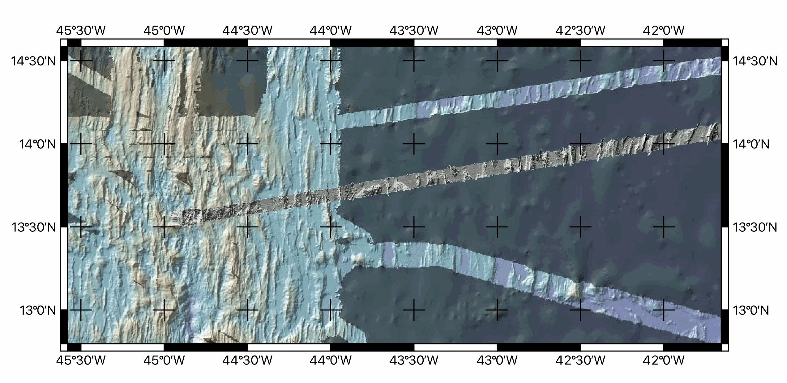
Multibeam bathymetry data, gridded at ~100m, acquired around during the transit towards the Mid-Atlantic ridge axis (13°20'N and 13°30'N oceanic detachments area) during the ODEMAR cruise (2013). Bathymetric data was acquired by the PourQUoi Pas? multibeam system (RESON SEABAT 7150). Data is provided as geotiffs (WGS84) ODM_transit_16Nov.tif Extent -27.8375538800000015,16.3530121699999995 : -26.3755538800000018,16.6860121699999979 Width 1463 Height 334 Data type Float32 - Thirty two bit floating point GDAL Driver Description GTiff GDAL Driver Metadata GeoTIFF Dataset Description /Users/jescartin/WORK/Proyectos/ODEMAR/DATA/Bathygrids/Transit/ODM_transit_16Nov.tif Compression PACKBITS Band 1 STATISTICS_MAXIMUM=-4139.5639648438 STATISTICS_MEAN=-4612.4823849892 STATISTICS_MINIMUM=-4866.7373046875 STATISTICS_STDDEV=121.40234041923 STATISTICS_VALID_PERCENT=29.85 Scale: 1 Offset: 0 More information AREA_OR_POINT=Area TIFFTAG_SOFTWARE=MATLAB 9.14, Mapping Toolbox 5.5 Dimensions X: 1463 Y: 334 Bands: 1 Origin -27.8375538800000015,16.6860121699999979 Pixel Size 0.0009993164730006834189,-0.0009970059880239474058 ODM_transit_17Nov.tif Extent -32.4955601099999996,15.5934151199999995 : -27.8195601099999976,16.4454151199999998 Width 4677 Height 853 Data type Float32 - Thirty two bit floating point GDAL Driver Description GTiff GDAL Driver Metadata GeoTIFF Dataset Description /Users/jescartin/WORK/Proyectos/ODEMAR/DATA/Bathygrids/Transit/ODM_transit_17Nov.tif Compression PACKBITS Band 1 STATISTICS_APPROXIMATE=YES STATISTICS_MAXIMUM=-4458.8168945312 STATISTICS_MEAN=-5144.8000932272 STATISTICS_MINIMUM=-5562.1850585938 STATISTICS_STDDEV=164.55246561258 STATISTICS_VALID_PERCENT=50.04 Scale: 1 Offset: 0 More information AREA_OR_POINT=Area TIFFTAG_SOFTWARE=MATLAB 9.14, Mapping Toolbox 5.5 Dimensions X: 4677 Y: 853 Bands: 1 Origin -32.4955601099999996,16.4454151199999998 Pixel Size 0.0009997861877271759391,-0.0009988276670574447458 ODM_transit_18Nov.tif Extent -36.9279732571747630,14.8264479347363469 : -32.4729732571747647,15.7054479347363465 Width 4456 Height 880 Data type Float32 - Thirty two bit floating point GDAL Driver Description GTiff GDAL Driver Metadata GeoTIFF Dataset Description /Users/jescartin/WORK/Proyectos/ODEMAR/DATA/Bathygrids/Transit/ODM_transit_18Nov.tif Compression PACKBITS Band 1 STATISTICS_APPROXIMATE=YES STATISTICS_MAXIMUM=-5171.58203125 STATISTICS_MEAN=-5712.1738558372 STATISTICS_MINIMUM=-5946.1611328125 STATISTICS_STDDEV=139.45706418798 STATISTICS_VALID_PERCENT=7.565 Scale: 1 Offset: 0 More information AREA_OR_POINT=Area TIFFTAG_SOFTWARE=MATLAB 9.14, Mapping Toolbox 5.5 Dimensions X: 4456 Y: 880 Bands: 1 Origin -36.9279732571747630,15.7054479347363465 Pixel Size 0.0009997755834829438748,-0.0009988636363636358394 ODM_transit_19Nov.tif Extent -41.3188024399999989,14.0843680599999992 : -36.8828024399999990,14.9493680599999994 Width 4437 Height 866 Data type Float32 - Thirty two bit floating point GDAL Driver Description GTiff GDAL Driver Metadata GeoTIFF Dataset Description /Users/jescartin/WORK/Proyectos/ODEMAR/DATA/Bathygrids/Transit/ODM_transit_19Nov.tif Compression PACKBITS Band 1 STATISTICS_APPROXIMATE=YES STATISTICS_MAXIMUM=-4540.5317382812 STATISTICS_MEAN=-5176.2961468757 STATISTICS_MINIMUM=-5426.123046875 STATISTICS_STDDEV=183.14492125461 STATISTICS_VALID_PERCENT=7.674 Scale: 1 Offset: 0 More information AREA_OR_POINT=Area TIFFTAG_SOFTWARE=MATLAB 9.14, Mapping Toolbox 5.5 Dimensions X: 4437 Y: 866 Bands: 1 Origin -41.3188024399999989,14.9493680599999994 Pixel Size 0.0009997746224926751767,-0.0009988452655889147342 ODM_transit_20Nov.tif Extent -44.9630377200000027,13.5018919999999998 : -41.3030377200000061,14.1828919999999989 Width 3661 Height 682 Data type Float32 - Thirty two bit floating point GDAL Driver Description GTiff GDAL Driver Metadata GeoTIFF Dataset Description /Users/jescartin/WORK/Proyectos/ODEMAR/DATA/Bathygrids/Transit/ODM_transit_20Nov.tif Compression PACKBITS Band 1 STATISTICS_APPROXIMATE=YES STATISTICS_MAXIMUM=-3173.7924804688 STATISTICS_MEAN=-4347.3027374804 STATISTICS_MINIMUM=-4821.65625 STATISTICS_STDDEV=276.6463937856 STATISTICS_VALID_PERCENT=42.31 Scale: 1 Offset: 0 More information AREA_OR_POINT=Area TIFFTAG_SOFTWARE=MATLAB 9.14, Mapping Toolbox 5.5 Dimensions X: 3661 Y: 682 Bands: 1 Origin -44.9630377200000027,14.1828919999999989 Pixel Size 0.0009997268505872703662,-0.000998533724340174662
-
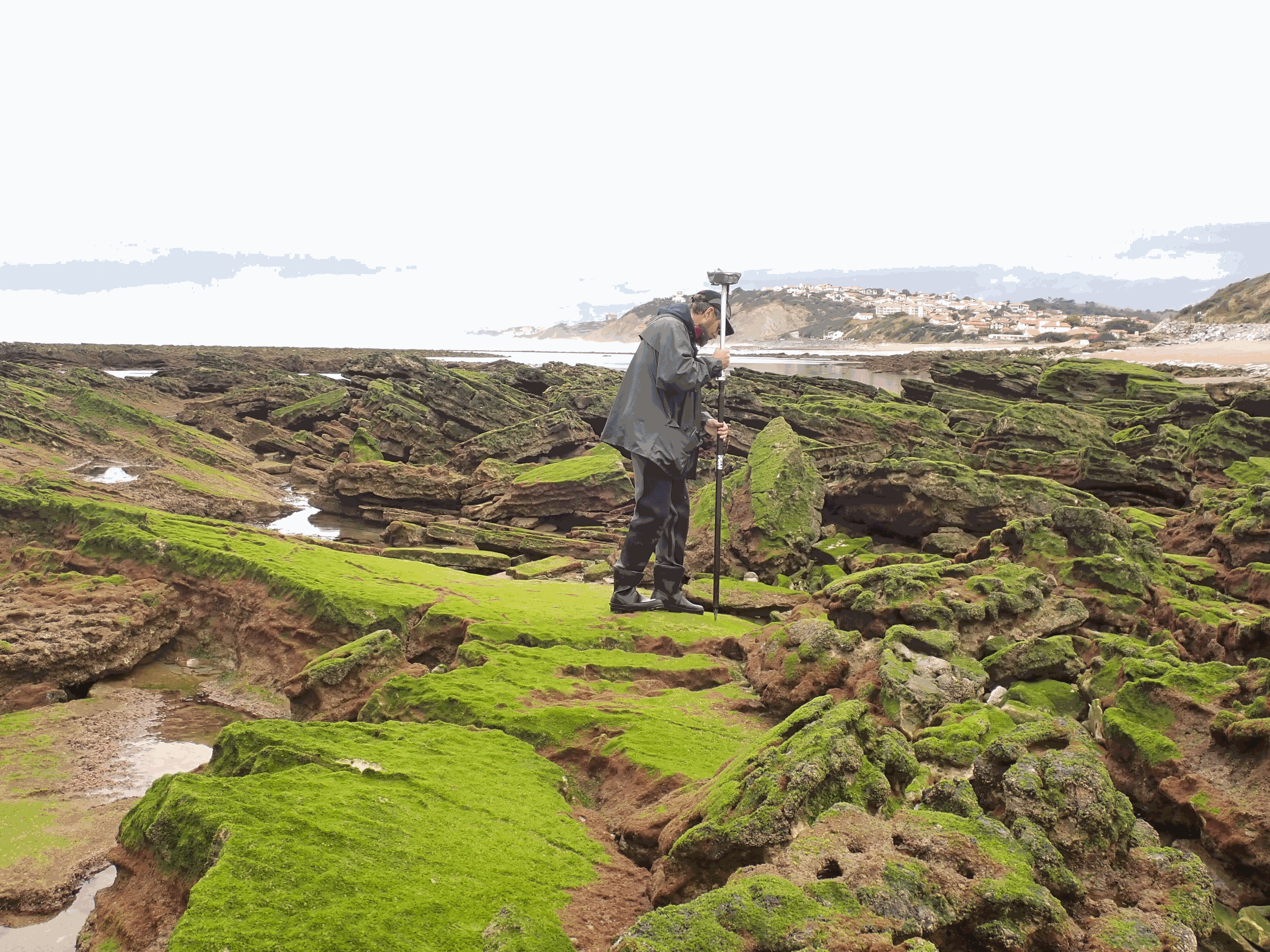
The present dataset is based on a nine site study of fine seabed topography in intertidal zones. Four coral sites (Maupiti A, B and C and Niau islands) and five rocky sites (Ars en Ré, Socoa, Parlementia A and B and Banneg island) have been explored. The data has been gathered using on-foot GNSS RTK for all sites (Trimble R8/R8S and Leica sytems) except Banneg island, where aerial Lidar data from Litto3D program has been used. The horizontal resolution varies between 3.8 and 12cm allowing to describe a wide range of spatial scales (generally over 3 spectral decades). The data has been processed to explore the statistical and spectral metrics which can be used to characterize the architectural complexity of seabeds.
-

A set of 4 map sheets: 1. Mang Luoi Song Ngoi : Vietnam : fond topographique des provinces de Gia Lai Kontum, Darlac et Lam Dong. Scale of 1:1 000 000. Date of publication: 1993. 2. Tay Nguyen - Dan Cu : Vietnam : fond topographique des provinces de Gia Lai Kontum, Darlac et Lam Dong. Scale of 1:1 000 000. Date of publication: 1993. 3. Tay Nguyen - Dia Hinh : Vietnam : fond topographique des provinces de Gia Lai Kontum, Darlac et Lam Dong. Scale of 1:1 000 000. Date of publication: 1993. 4. Tho Nhuong : Vietnam : fond topographique des provinces de Gia Lai Kontum, Darlac et Lam Dong. Scale of 1:1 000 000. Date of publication: 1993.
-

One mosaic of 2 map sheets: 1. Topographie du plateau continental ivoirien : carte No 1 - de la Lagune Tendo à la Lagune Tadio. Scale of 1:294 200. Date of publication: 1967. 2. Topographie du plateau continental ivoirien : carte No 2 - de la Rivière Bolo au Fleuve Cavally. Scale of 1:294 200. Date of publication: 1967.
-
Grimari : esquisse pédologique. A set of 2 map sheets. Scale of 1:50 000. Date of publication: 1963.

A set of 2 map sheets: 1. Grimari : esquisse pédologique. Scale of 1:50 000. Date of publication: 1963. 2. Grimari : topographie et végétation. Scale of 1:50 000. Date of publication: 1963.
-

One mosaic of 2 map sheets: 1. Carte oro-hydrographique de la République Centrafricaine feuille Est. Scale of 1:1 000 000. Date of publication: 1987. 2. Carte oro-hydrographique de la République Centrafricaine feuille Ouest. Scale of 1:1 000 000. Date of publication: 1987.
-

The map sheet: 1. Carte des pentes et du modelé de la Guadeloupe (partie volcanique). Scale of 1:100 000. Date of publication: unknown.
-

The map sheet: 1. Carte orographique des régions du Logar, de Kabul, de Bamyan, du Nuristan, du Paktia et de la terminaison occidentale de l'Hindu Kuch. Scale of 1:1 300 000. Date of publication: 1976.
-

One mosaic of 3 map sheets: 1. Topographie du plateau continental libérien : carte No 1 - du Fleuve Cavally à la Rivière Little Kru. Scale of 1:300 000. Date of publication: 1967. 2. Topographie du plateau continental libérien : carte No 2 - de la Rivière Little Kru à la Pointe Long Reef. Scale of 1:300 000. Date of publication: 1967. 3. Topographie du plateau continental libérien : carte No 3 - de la Pointe Long Reef à la Rivière Manna. Scale of 1:300 000. Date of publication: 1967.
-

The map sheet: 1. Bassin versant du Sénégal : carte hypsométrique. Scale of 1:2 000 000. Date of publication: 1974.