 Metadata catalogue
soil
Type of resources
Available actions
Topics
INSPIRE themes
Keywords
Contact for the resource
Provided by
Years
Formats
Representation types
Update frequencies
status
Service types
Scale
Resolution
-

INSPIRE View Service enables access to soil maps at a scale of 1 : 50,000 of the new digital edition of the Czech Geological Survey (since 2012).
-
Soil map at a scale of 1:1M, compiled by Milan Tomášek. The map includes also the soil grain size layer. The classification of soil types was updated in 2016 according to the Taxonomy system for soils in the Czech Republic and World Reference Base for Soil Resources 2014, update 2015.
-
The map shows the vulnerability of subsoils to compaction by traffic. It covers most of Scotland’s cultivated agricultural land area. The subsoil compaction risk gives information on the likelihood of the subsoil becoming compacted due to heavy machinery in four classes (Extremely vulnerable, Very vulnerable, Moderately vulnerable or Not particularly vulnerable) based on the soil texture and the amount of water left in the soil after any excess has drained away (known as field capacity).
-
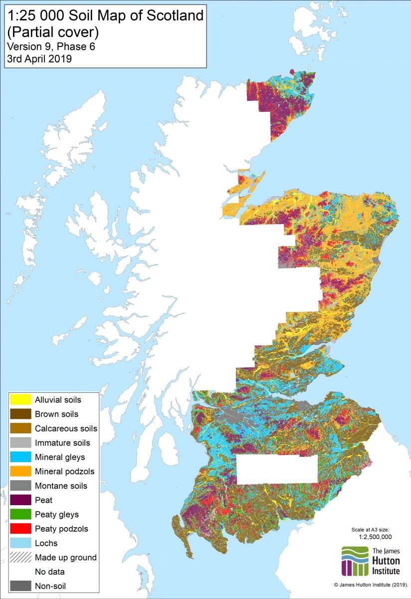
This is the digital dataset which was created by digitising the Soils of Scotland 1:25,000 Soil maps and the Soils of Scotland 1:25,000 Dyeline Masters. The Soils of Scotland 1:25,000 Soil maps were the source documents for the production of the Soils of Scotland 1:63,360 and 1:50,000 published map series. The classification is based on Soil Associations, Soil Series and Phases which reflect parent material, major soil group, and soil sub-groups, drainage and (for phases), texture, stoniness, land use, rockiness, topography and organic matter. Phases are not always mapped. In general terms this dataset primarily covers the cultivated land of Scotland but also includes some upland areas . Not all of the available source documents have been digitised. Should there be a requirement for other areas to be captured, the Internal Contact should be contacted in the first instance. Attribute definitions: The attributes on each map (coverage) are specific to that map sheet, but in general terms the following categories are mapped: soil association, soil series, parent material, soil complexes, soil phases, skeletal soils, alluvial soils, organic soils, miscellaneous soils, mixed bottom land, built-up area, quarries/disturbed ground, collieries/bings, golf courses.
-

The systematic survey of the soils of Scotland was commenced in 1947 by staff of the Macaulay Institute for Soil Research. This dataset is the digital (vector) version of the Soils of Scotland 1:250,000 maps, which is a generalised soil map, partly derived from a 1:50,000 map of the soils of Scotland. This dataset is an inventory of the soils of Scotland and was intended for use by planners etc. This dataset has the soil lines extrapolated over the built-up areas. The soil classification used was updated in 2013 to provide a unified classification across all Soil Survey of Scotland soil maps and profile datasets(UCSS).Version 1.1 of the data includes both the original 1984 and the 2013 soil classification.
-
Maps show soil cover of a certain area. They express both the typological relevance of the soil (soil type, subtype, hydromorphic development, soil variety and form), as well as data on the soil-forming substrate.
-
Land Monitoring Sites in Scotland
-
Soil Monitoring Sites in Scotland
-

Soil samples are collected once a year from four points along Malta and Gozo. Samples are sent to an accredited Laboratory for radionuclide analysis. Such monitoring is carried out according to the requirements arising from Commission Recommendation 2000/473/Euratom.
-

The site Crique Bastien is composed of two 3km-transects (20m wide). 2608 trees with dbh>=20cm have been recorded by Office national des forêts (ONF). No fauna inventories available. No under-storey plants inventories are available. Soils have been described using 3 samples (1.20m depth max.). No laboratory analysis available for soils.