 Metadata catalogue
sedimentology
Type of resources
Available actions
Topics
INSPIRE themes
Keywords
Contact for the resource
Provided by
Years
Formats
Representation types
Update frequencies
status
Service types
Scale
-
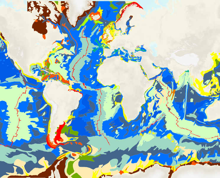
The “World Seabed Sediment Map” product contains geo-referenced digital data, describing the nature of the sediment encountered in different seas and oceans of the world. The objects are all surface areas and the description of an object includes in particular the nature of the sediment including rock-type bottoms.
-

Results of side-scan sonar mapping within the framework of the German Coastal Engineering Research Council project AufMod (¿Aufbau integrierter Modellsysteme zur Analyse der langfristigen Morphodynamik in der Deutschen Bucht¿ [¿Development of integrated model systems for the analysis of long-term morphodynamics in the German Bight¿], 01.11.2009-31.12.2012): -survey lines of side-scan sonar surveys -grab stations for ground truthing -sediment maps
-

2 mosaics of 3 map sheets: 1. Abidjan : carte sédimentologique du plateau continental de Côte d'Ivoire. Scale of 1:945 080 to 1:200 000. Date of publication: 1972. 2. Grand-Lahou : carte sédimentologique du plateau continental de Côte d'Ivoire. Scale of 1:945 080 to 1:200 000. Date of publication: 1972. 3. San Pedro : carte sédimentologique du plateau continental de Côte d'Ivoire. Scale of 1:945 080 to 1:200 000. Date of publication: 1972.
-

One mosaic of 4 map sheets: 1. La Tontouta : carte sédimentologique du lagon de Nouvelle Calédonie = La Tontouta : sedimentological map of the New Caledonian lagoon. Scale of 1:50 000. Date of publication: 1979. 2. Mont Dore : carte sédimentologique du lagon de Nouvelle Calédonie = Mont Dore : sedimentological map of the New Caledonian lagoon. Scale of 1:50 000. Date of publication: 1978. 3. Nouméa : carte sédimentologique du lagon de Nouvelle-Calédonie = Nouméa : sedimentological map of the New Caledonia lagoon. Scale of 1:50 000. Date of publication: 1980. 4. Prony : carte sédimentologique du lagon de Nouvelle-Calédonie = Prony : sedimentological map of the New Caledonian lagoon. Scale of 1:50 000. Date of publication: 1981.
-

2 mosaics of 2 map sheets: 1. Nouadhibou : carte sédimentologique du Plateau Continental Mauritanien. Scale of 1:1 000 000 to 1:200 000. Date of publication: 1985. 2. Nouakchott : carte sédimentologique du Plateau Continental Mauritanien. Scale of 1:1 000 000 to 1:200 000. Date of publication: 1985.
-

2 mosaics of 2 map sheets: 1. Carte sédimentologique du Plateau continental guinéen : Conakry (est). Scale of 1:1 000 000 to 1:200 000. Date of publication: 1993. 2. Carte sédimentologique du Plateau continental guinéen : Conakry (ouest). Scale of 1:1 000 000 to 1:200 000. Date of publication: 1993.
-

Data were generated within the framework of the German Coastal Engineering Research Council project AufMod (¿Aufbau integrierter Modellsysteme zur Analyse der langfristigen Morphodynamik in der Deutschen Bucht¿ [¿Development of integrated model systems for the analysis of long-term morphodynamics in the German Bight¿], 01.11.2009-31.12.2012). Various sedimentological parameters processed as products for the German Bight area were calculated from interpolated grain size distributions: - "Median_Grain_Size": Median-Durchmesser (D50) der interpolierten Kornsummenkurve - "Mean_Grain_Size": Mittelwert des Korndurchmessers - "Sorting1": Sortierung after Trask (1932): sqrt(D75/D25) - "Sorting2": Sortierung after Folk and Ward (1957): (phi84-phi16)/4+(phi95-phi5)/6.6 - "Skewness": Skewness after Folk and Ward (1957): (phi16+phi84-2phi50)/2(phi84-phi16)+(phi5+phi95-2phi50)/2(phi95-phi5) - "Kurtosis": Kurtosis after Folk and Ward (1957): (phi95-phi5)/2.44(phi75-phi25) - "GSF_micrometer": content of sand fractions (half phi° intervals) [%], 63 to 2000 micrometers - "PredominantSandFractions": spatial distribution of sediment fractions with a coontent 50 % / 20 % - 50 %
-

Various paramters for analysing morphodynamics in the German Bight on the basis of a 32 years time series aof interpolated bathymatries (yeasr 1982 - 2012). The data were generated within the framework of the German Coastal Engineering Research Council project AufMod (¿Aufbau integrierter Modellsysteme zur Analyse der langfristigen Morphodynamik in der Deutschen Bucht¿ [¿Development of integrated model systems for the analysis of long-term morphodynamics in the German Bight¿], 01.11.2009-31.12.2012). - "Morphological Alteration": differences in depth between two annual topographies for different periods (1, 5, 10, 30 years periods). - "Morphological Space": maximum difference in height at each model grid point (Zmax-Zmin) for different periods (1, 5, 10, 30 years) - "Morphological Drive": Difference between the maximum and the minimum annual rate of change in the period under consideration ((dz/a)max-( dz/a)min); 1, 5, 10, 30 years). With this parameter, it is possible to make a declaration as to whether a morphological alteration constantly takes place throughout the period under consideration or extreme results have occurred - "Count Of Datasets": amount of field campaigns present in the respective period under consideration - "Considerd Period": Time interval which is actually covered with data within the period under consideration [decimal years]
-

A set of 2 map sheets: 1. Carte des fonds du plateau continental du Dahomey et du Togo. Scale of 1:208 000. Date of publication: 1966. 2. Positions des dragages : trajets suivant lesquels la prospection au sondeur US a été exécutée. Scale of 1:303 000. Date of publication: 1966.
-

4 mosaics of 3 map sheets: 1. Buéa-Douala : carte sédimentologique du plateau continental du Cameroun. Scale of 1:200 000. Date of publication: 1996. 2. Kribi : carte sédimentologique du plateau continental du Cameroun. Scale of 1:200 000. Date of publication: 1996. 3. Mouanko : carte sédimentologique du plateau continental du Cameroun. Scale of 1:200 000. Date of publication: 1996.