 Metadata catalogue
product
Type of resources
Available actions
Topics
INSPIRE themes
Keywords
Provided by
Representation types
Scale
-
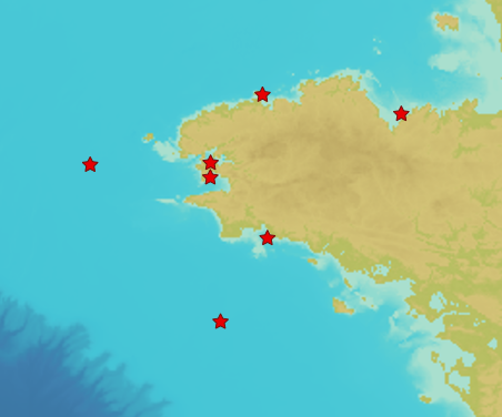
In early 2017, Shom established a near-bottom turbidity observation network to measure turbidity and currents near the seabed continuously, at high frequency and over a long period of time (several years). Seven mooring points with ecological and / or sedimentological interests and impacted by anthropogenic activities (except the control point in the Celtic Sea) have thus been defined. The product "Turbidity Time Series ROEC" contains turbidity level records measured in NTU by optical turbidimeters implanted at each of the 7 wetting points of the monitoring network as well as currents recordings (speed (m/s) and direction (°) measured by a single-point current meter. The data present in the product "ROEC Turbidity Time Series" corresponds to raw data from NTUS sensors (Wetlabs) and Aquadopp (Nortek) deployed on different moorings and transcoded in .CSV format. The time series are provided in their entirety and have not been post-processed. The files can therefore include certain erroneous values related to specific anomalies in the acquisition made by the sensor or intervals without data when the acquisition knows ranges of interruption.
-

Information layer containing the SAR Zones (Search and Rescue). This layer contains a description of the French search and rescue (SAR) areas and the location of the associated Maritime Rescue Coordination Center (MRCC). it covers the areas of responsibility of France. The layer was produced by the Shom pursuant to the Circular Circular of the International Maritime Organization (IMO No. SAR.8 / Circ.4 of 1 December 2012).
-
The land-sea limit corresponds to the Highest Astronomical Tide (HAT) in the case of a tide of coefficient 120 and under normal meteorological conditions (no offshore wind and mean atmospheric pressure of 1013 hPa). This geometric line is naturally defined as the intersection of a HAT model (extended to the coast and the top end of the upper estuary) based on the available Bathyelli surfaces, and a high-resolution digital terrain model of the coastal area. It corresponds to the highest limit of the intertidal area and takes into account, when they exist, the 3 administrative maritime limits which are: the transversal limit of the sea (LTM), the salt water limit (LSE) and the limit of maritime jurisdiction (LAM). This limit is measured (quoted) in relation to the local hydrographic chart datum and to the levels of reference for France (IGN69 and IGN78 for Corsica). Relations to other levels of reference (mean sea level and ellipsoid) are known. The land-sea limit product, mainly results from the exploitation of the two products Litto3D®/RGEALTI® and Bathyelli, and represents, with a metric resolution (1 to 5 metres), this theoretical entity by a set of 2D polylines describing the nature of the coast (artificial or natural, rocky or sandy, steep or flat, etc.). The method used for calculating the land-sea limit makes it possible to produce a continuous, homogeneous and spatially coherent limit on the entire French metropolitan coastal area.