 Metadata catalogue
morphology
Type of resources
Available actions
Topics
Keywords
Contact for the resource
Provided by
Years
Formats
Service types
-
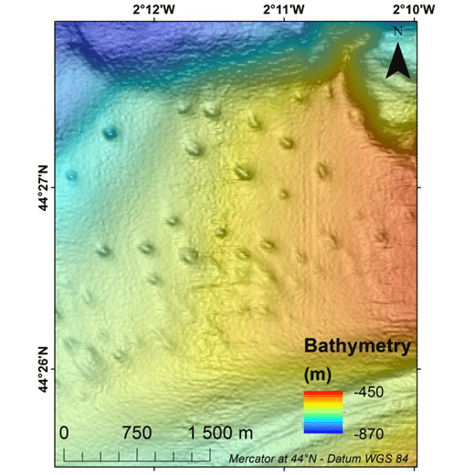
Pockmarks are defined as depressions on the seabed and are usually formed by fluid expulsions. Recently discovered, pockmarks along the Aquitaine slope within the French EEZ, were manually mapped although two semi-automated methods were tested without convincing results. In order to potentially highlight different groups and possibly discriminate the nature of the fluids involved in their formation and evolution, a morphological study was conducted, mainly based on multibeam data and in particular bathymetry from the marine expedition GAZCOGNE1, 2013. Bathymetry and seafloor backscatter data, covering more than 3200 km², were acquired with the Kongsberg EM302 ship-borne multibeam echosounder of the R/V Le Suroît at a speed of ~8 knots, operated at a frequency of 30 kHz and calibrated with ©Sippican shots. Precision of seafloor backscatter amplitude is +/- 1 dB. Multibeam data, processed using Caraibes (©IFREMER), were gridded at 15x15 m and down to 10x10 m cells, for bathymetry and seafloor backscatter, respectively. The present table includes 11 morphological attributes extracted from a Geographical Information System project (Mercator 44°N conserved latitude in WGS84 Datum) and additional parameters related to seafloor backscatter amplitudes. Pockmark occurrence with regards to the different morphological domains is derived from a morphological analysis manually performed and based on GAZCOGNE1 and BOBGEO2 bathymetric datasets. The pockmark area and its perimeter were calculated with the “Calculate Geometry” tool of Arcmap 10.2 (©ESRI) (https://desktop.arcgis.com/en/arcmap/10.3/manage-data/tables/calculating-area-length-and-other-geometric-properties.htm). A first method to calculate pockmark internal depth developed by Gafeira et al. was tested (Gafeira J, Long D, Diaz-Doce D (2012) Semi-automated characterisation of seabed pockmarks in the central North Sea. Near Surface Geophysics 10 (4):303-315, doi:10.3997/1873-0604.2012018). This method is based on the “Fill” function from the Hydrology toolset in Spatial Analyst Toolbox Arcmap 10.2 (©ESRI), (https://pro.arcgis.com/en/pro-app/tool-reference/spatial-analyst/fill.htm) which fills the closed depressions. The difference between filled bathymetry and initial bathymetry produces a raster grid only highlighting filled depressions. Thus, only the maximum filling values which correspond to the internal depths at the apex of the pockmark were extracted. For the second method, the internal pockmark depth was calculated with the difference between minimum and maximum bathymetry within the pockmark. Latitude and longitude of the pockmark centroid, minor and major axis lengths and major axis direction of the pockmarks were calculated inside each depression with the “Zonal Geometry as Table” tool from Spatial Analyst Toolbox in ArcGIS 10.2 (©ESRI) (https://pro.arcgis.com/en/pro-app/tool-reference/spatial-analyst/zonal-statistics.htm). Pockmark elongation was calculated as the ratio between the major and minor axis length. Cell count is the number of cells used inside each pockmark to calculate statistics (https://pro.arcgis.com/en/pro-app/tool-reference/spatial-analyst/zonal-geometry.htm). Cell count and minimum, maximum and mean bathymetry, slope and seafloor backscatter values were calculated within each pockmark with “Zonal Statistics as Table” tool from Spatial Analyst Toolbox in ArcGIS 10.2 (©ESRI). Slope was calculated from bathymetry with “Slope” function from Spatial Analyst Toolbox in ArcGIS 10.2 (©ESRI) and preserves its 15 m grid size (https://pro.arcgis.com/en/pro-app/tool-reference/spatial-analyst/slope.htm). Seafloor backscatter amplitudes (minimum, maximum and mean values) of the surrounding sediments were calculated within a 100 m buffer around the pockmark rim.
-

Various paramters for analysing morphodynamics in the German Bight on the basis of a 32 years time series aof interpolated bathymatries (yeasr 1982 - 2012). The data were generated within the framework of the German Coastal Engineering Research Council project AufMod (¿Aufbau integrierter Modellsysteme zur Analyse der langfristigen Morphodynamik in der Deutschen Bucht¿ [¿Development of integrated model systems for the analysis of long-term morphodynamics in the German Bight¿], 01.11.2009-31.12.2012). - "Morphological Alteration": differences in depth between two annual topographies for different periods (1, 5, 10, 30 years periods). - "Morphological Space": maximum difference in height at each model grid point (Zmax-Zmin) for different periods (1, 5, 10, 30 years) - "Morphological Drive": Difference between the maximum and the minimum annual rate of change in the period under consideration ((dz/a)max-( dz/a)min); 1, 5, 10, 30 years). With this parameter, it is possible to make a declaration as to whether a morphological alteration constantly takes place throughout the period under consideration or extreme results have occurred - "Count Of Datasets": amount of field campaigns present in the respective period under consideration - "Considerd Period": Time interval which is actually covered with data within the period under consideration [decimal years]
-

DTM of the German Bight (yearly, 1982 - 2012). Classified isosurfaces of spatiotemporally interpolated bathymetries from the years 1982 to 2012, with two parameters for the purposes of reliability: Confidence and Minimum dt. The parameter Confidence [m] indicates the reliability of the modelled bathymetry. Data were generated within the framework of the German Coastal Engineering Research Council project AufMod (¿Aufbau integrierter Modellsysteme zur Analyse der langfristigen Morphodynamik in der Deutschen Bucht¿ [¿Development of integrated model systems for the analysis of long-term morphodynamics in the German Bight¿], 01.11.2009-31.12.2012).