 Metadata catalogue
forest carbon
Type of resources
Topics
Keywords
Contact for the resource
Provided by
Years
Formats
Representation types
Update frequencies
status
Scale
-
Africadiv is a network of 1-ha forest monitoring plots spread across the moist forests in central Africa. This dataset holds the biomass calculated from plot inventory data......
-
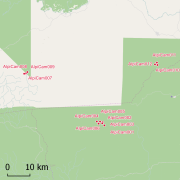
Africadiv is a network of 1-ha forest monitoring plots spread across the moist forests in central Africa. The Cameroonian site of Mindourou II is composed of 12 1-ha forest plots. The following data are available for the different plots at this site: Structure - DBH of all trees ≥ 10 cm DBH : n = 5 598 Structure - Tree height : n = 920 Structure - Trunk height : n = 667 Structure - Crown diameter : n = 233 Identification rate - species-level : 56.4 % Identification rate - genus-level : 26.2 % Identification rate - family-level : 11.7 % Identification rate - unidentified : 5.7 % Soil samples & analyses available : YES Geolocation : GPS points and laser measurements (distance, vertical & horizontal angles) every 20 m on the contour of the plot. These data are routinely collected and used by AMAP research unit (IRD) and partners (LaboSyst, Yaoundé 1 University). Scientific collaboration are welcomed, please get in touch with a Point of contact.