 Metadata catalogue
fishery
Type of resources
Available actions
Topics
INSPIRE themes
Keywords
Contact for the resource
Provided by
Years
Formats
Representation types
Update frequencies
status
Scale
Resolution
-

These datasets (Jan, Feb, April-December 2014) were produced in aggregated maps by showing the intensity of VMS (and not the effort) by the use of VMSBase-free software and Rstudio software (2009-2014, Inc. Version 0.98.1091) through a knowledge gained at VMSBase Training course, IMC-CNR, Ancona, Italy held in October 2015. This data was included as part of the dataset used for one of the co-financed EU LIFE+ Funding Programmes - LIFE BaĦAR for N2K project.
-

This dataset was created within the framework of the S3-EUROHAB project. It contains the vulnerability index of scallop fishing vessels exposed to the risk of harvest closures due to HABs toxins and the potential contamination in scallops, as well as the sensitivity, exposure and adaptive capacity indicators used to calculate the vulnerability composite index. These data cover the French coasts of the eastern English Channel and the period of the scallop fishing season between 2012-2013 and 2018-2019. The indicators are calculated per fishing fleet category which corresponds to a segmentation based on the intersection between vessel lenghth and fishing technique. The identification of indicators describing the vulnerability components (exposure, sensitivity and adaptive capacity) is based on characteristics of the (1) French scallop fishery in the eastern English Channel and (2) the HABs impacts in this area. The exposure indicator is represented by the ratio of the closure duration compared to the total authorised fishing duration for each season. The sensitivity of fishermen is characterised by the dependency of fishing vessels on scallop production and on fishing areas likely to be closed during scallop toxicity periods. Adaptive capacity is defined as the strategies of fishermen to avoid the impacts of closures. It is composed of two indicators: the capacity to change fishing areas and the capacity to change target species (scallops). All the variables in this dataset are described in the dictionary of the attribute table associated to this metadata descrition.
-
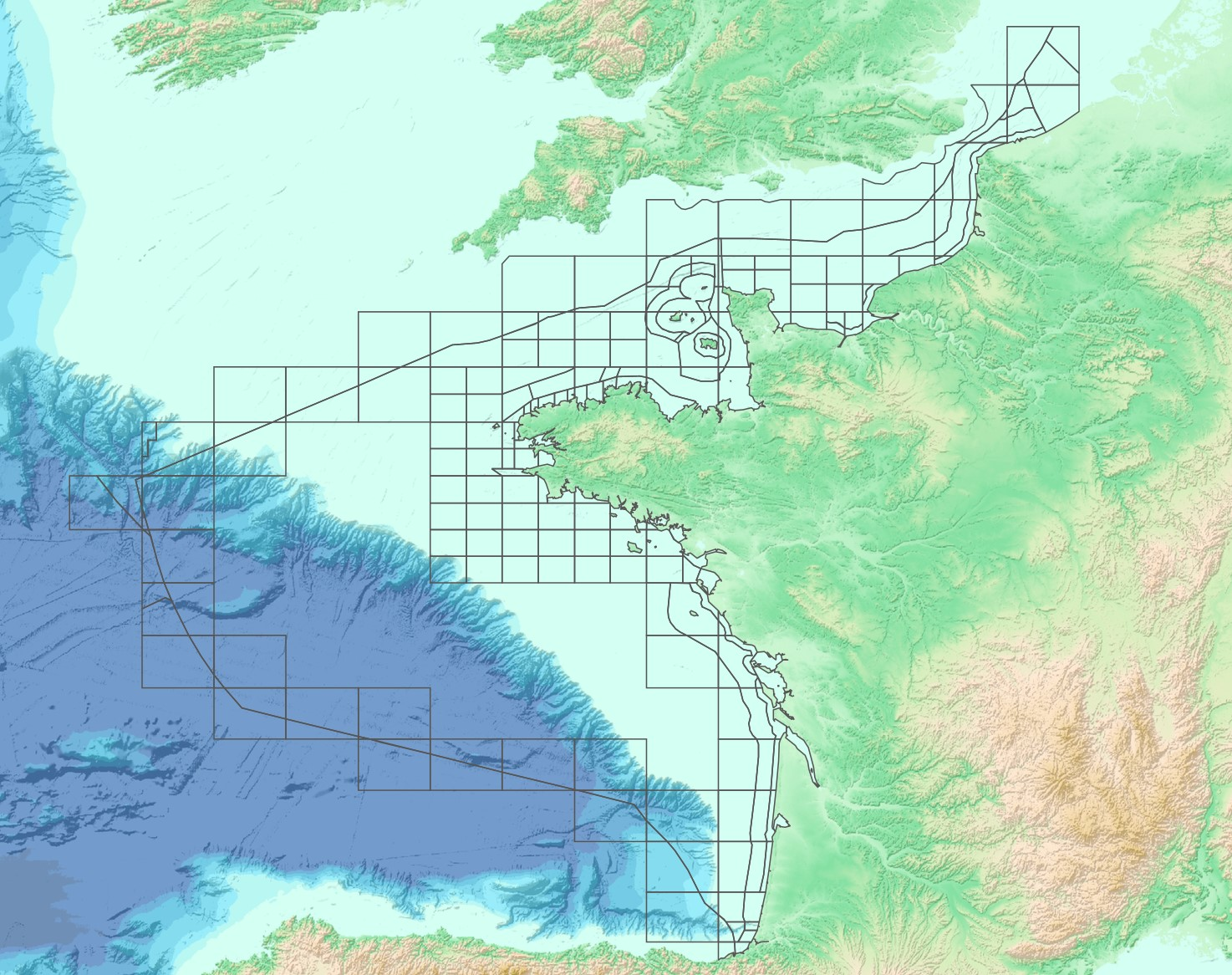
The “French sub-rectangles of the ICES fishery statistical rectangles” product contains 2D areas vector objects representing a sub-rectangle division of ICES statistical rectangles. Each product polygon belongs to an unique ICES rectangle. This subdivision enables distinction between overlapping areas in two or more EEZs, areas of functional interest and areas of regulatory interest.
-

A set of 8 map sheets: 1. Carte 1 : l'eau, 1980 -1990. Scale of 1:500 000. Date of publication: 1994. 2. Carte 2 : croquis morpho-pédologique. Scale of 1:500 000. Date of publication: 1994. 3. Carte 3 : répartition de la population recensée, 1987. Scale of 1:500 000. Date of publication: 1994. 4. Carte 4 : les pêcheurs et la pêche. Scale of 1:500 000. Date of publication: 1994. 5. Carte 5 : emprise agricole et pastorale. Scale of 1:500 000. Date of publication: 1994. 6. Carte 6 : communications et marchés. Scale of 1:500 000. Date of publication: 1994. 7. Carte 7 : l'histoire du peuplement et la structuration du delta. Scale of 1:500 000. Date of publication: 1994. 8. Carte 8 : les changements dans le delta central. Scale of 1:500 000. Date of publication: 1994.
-
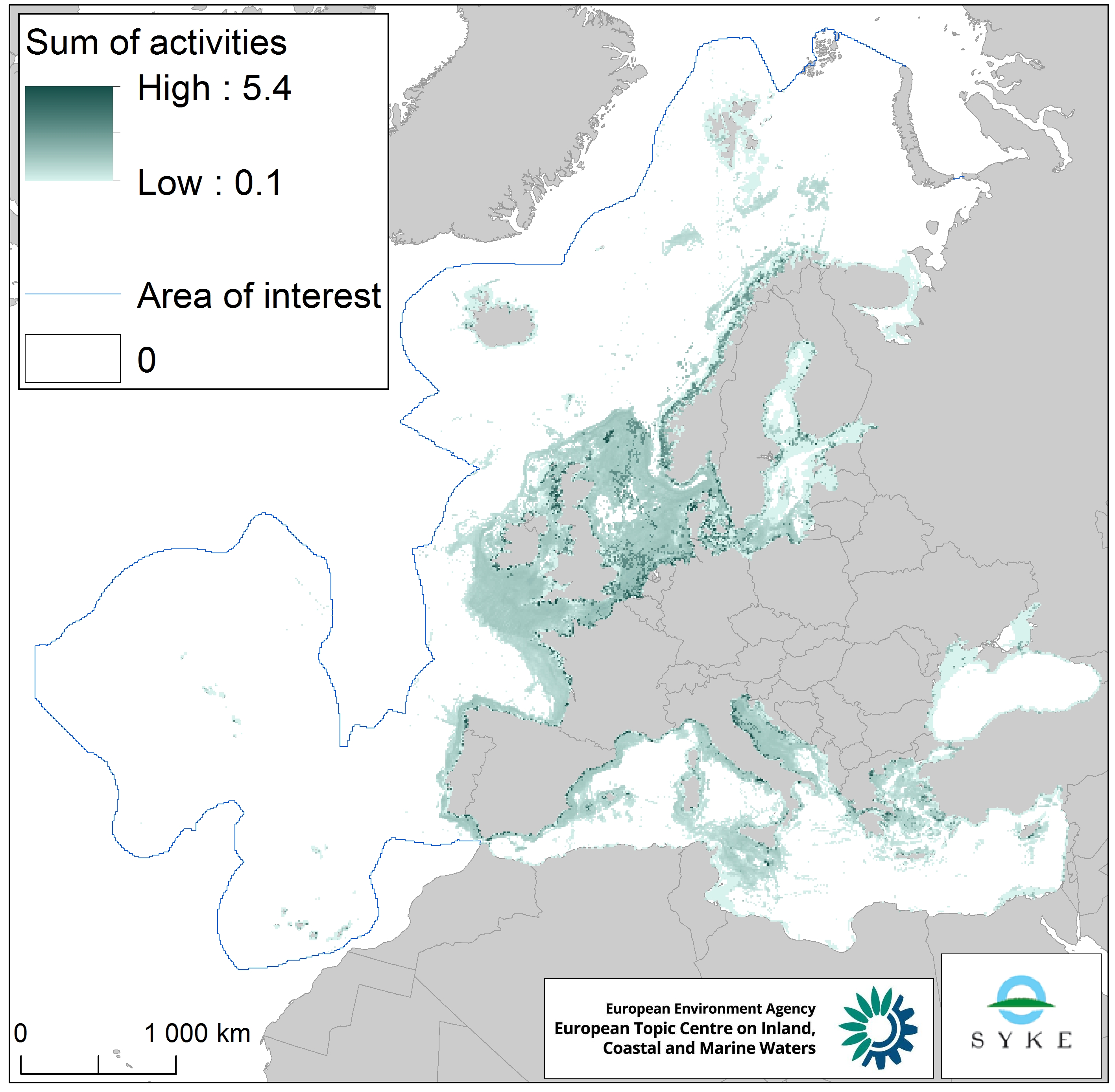
This raster dataset represents physical disturbance to the seabed in the European seas. Several human activities disturb the seabed either directly or indirectly. Alteration of benthic living conditions as a result of increased sedimentation or attenuation of light penetration, abrasion of the seabed and exploitation of benthic biota, temporarily disturb the benthic habitat quality. The dataset is an aggregation of several different human activities that cause physical disturbance to the seabed: aquaculture, demersal fishing, dredging and dumping of dredged material, oil and gas rigs, offshore installations, ports, sand and gravel extraction, shellfish mariculture, shipping in shallow waters and windfarms. The resulting dataset is a raster (10km grid cell) derived from EMODnet, MED-IAMER, JRC-STECF, OSPAR, HELCOM and 4C Offshore datasets, and with reference temporal coverage from 2012 to 2017. This dataset has been prepared for the calculation of the combined effect index, produced for the ETC/ICM Report 4/2019 "Multiple pressures and their combined effects in Europe's seas" available on: https://www.eionet.europa.eu/etcs/etc-icm/etc-icm-report-4-2019-multiple-pressures-and-their-combined-effects-in-europes-seas-1.
-

A set of 38 map sheets: 1. Aliments de famine : planche 21. Scale of 1:650 000. Date of publication: 1999. 2. Archéologie : région Mandara - Diamaré : Localisation des sites archéologiques. Traditions céramiques de l'Age du fer ancien. Traditions céramiques de l'Age du fer moyen 1. Traditions céramiques de l'Age du fer moyen 2 : planche 12. Scale of 1:650 000. Date of publication: 1999. 3. Climatologie Agroclimatologie : planche 2 : Précipitations moyennes annuelles (période 1944-1995). Scale of 1:53 000 000 to 1:1 100 000. Date of publication: 1999. 4. Cultures maraîchères : planche 19. Scale of 1:650 000. Date of publication: 1999. 5. Elevage I : densité du bétail : Nombre de bovins pour 100 habitants (en 1980). Charge théorique en bovins par kilomètre carré (en 1980). Charges en ovins-caprins par kilomètre carré (en 1980). Evolution des cheptels bovins (entre 1964 et 1980 et entre 1980 et 1988) : planche 22. Scale of 1:2 500 000 to 1:2 200 000. Date of publication: 1999. 6. Elevage II : transhumances: planche 23. Scale of 1:650 000. Date of publication: 1999. 7. Enseignement : enseignement primaire : planche 28 I. Scale of 1:650 000. Date of publication: 1999. 8. Enseignement : Taux de scolarisation par canton. Scolarisation féminine par canton. Nombre d'élèves par maître et par canton. Nombre d'élèves par classe et par canton : planche 28 II. Scale of 1:1 562 500. Date of publication: 1999. 9. Evolution de l'organisation politico-administrative : 1917, 1925, 1933, 1950, 1960, 1979, 1981, 1991 : planche 9 II. Scale of 1:2 500 000. Date of publication: 1999. 10. Géomorphologie : planche 1. Scale of 1:650 000. Date of publication: 1999. 11. Hydraulique villageoise : puits et forages : planche 26. Scale of 1:650 000. Date of publication: 1999. 12. Hydrogéologie : planche 4. Scale of 1:650 000. Date of publication: 1999. 13. Hydrologie : planche 3. Scale of 1:650 000. Date of publication: 1999. 14. Infrastructure sanitaire : planche 27. Scale of 1:650 000. Date of publication: 1999. 15. Infrastructures : planche 25. Scale of 1:650 000. Date of publication: 1999. 16. La pêche dans le lac de Maga : localisation, effectifs et techniques : planche 24. Scale of 1:100 000. Date of publication: 1999. 17. Les Fulbe : planche 8. Scale of 1:650 000. Date of publication: 1999. 18. Linguistique : langues maternelles : répartition géographique : planche 11 II. Scale of 1:650 000. Date of publication: 1999. 19. Linguistique : langues maternelles et véhiculaires : 1 Les langues maternelles : nombre de locuteurs. 2 Les langues véhiculaires : aires d'influence : planche 11 III. Scale of 1:1 000 000. Date of publication: 1999. 20. Maroua : évolution historique : Maroua vers 1890. Maroua en 1951. Maroua en 1997 : planche 30. Scale of 1:25 000 to 1:16 000. Date of publication: 1999. 21. Maroua : l'emprise agricole de la ville : planche 32 II. Scale of 1:215 000 to 1:195 000. Date of publication: 1999. 22. Maroua : répartition ethnique et densités de population 1995 : planche 31. Scale of 1:36 363. Date of publication: 1999. 23. Maroua : répartition socio-professionnelle : planche 32 I. Scale of 1:25 000. Date of publication: 1999. 24. Mise en place du peuplement : les migrations peuples et Arabes showa de la fin du XVIè au début du XIXè siècle : planche 7 II. Scale of 1:1 000 000. Date of publication: 1999. 25. Mise en place du peuplement : migrations des populations du Bassin du lac Tchad : planche 7 I. Scale of 1:1 000 000. Date of publication: 1999. 26. Organisation de l'espace et pouvoirs traditionnels (fin du XIXè siècle) : planche 9 I. Scale of 1:650 000. Date of publication: 1999. 27. Parcs et végétations anthropiques : planche 6. Scale of 1:650 000. Date of publication: 1999. 28. Phytogéographie : planche 5. Scale of 1:650 000. Date of publication: 1999. 29. Potentialités des sols et terroirs agricoles : planche 13. Scale of 1:650 000. Date of publication: 1999. 30. Production arachidière : planche 16. Scale of 1:650 000. Date of publication: 1999. 31. Production cotonnière : Campagne agricole 1985-1986. Campagne agricole 1996-1997 : planche 18. Scale of 1:1 000 000. Date of publication: 1999. 32. Production rizicole : planche 17. Scale of 1:650 000. Date of publication: 1999. 33. Religions : planche 29. Scale of 1:650 000. Date of publication: 1999. 34. Répartition et densité de la population : Densité de la population (en 1980). Evolution de la population (de 1968 à 1987) : planche 10. Scale of 1:1 000 000. Date of publication: 1999. 35. Répartition ethnique : planche 7 III. Scale of 1:650 000. Date of publication: 1999. 36. Sorghors et civilisations agraires : Variétés. Aires de cultures : planche 14. Scale of 1:1 000 000. Date of publication: 1999. 37. Stratégies de conservation du grain : Les grands types de silos. Techniques traditionnelles de conservation : planche 20. Scale of 1:1 000 000. Date of publication: 1999. 38. Une légumineuse alimentaire, le niébé : planche 15. Scale of 1:1 000 000 to 1:650 000. Date of publication: 1999.
-

16 mosaics of 17 map sheets and a set of 93 additional map sheets 1. Autres atolls des Tuamotu : oro-hydrographie : planche 14. Scale of 1:150 000. Date of publication: 1993. 2. L'agriculture et l'utilisation du sol - I : planche 84. Scale of 1:100 000. Date of publication: 1993. 3. L'agriculture et l'utilisation du sol - II : planche 85. Scale of 1:15 000 000 to 1:62 000. Date of publication: 1993. 4. L'aménagement et la gestion des milieux : planche 110. Scale of 1:50 000. Date of publication: 1993. 5. L'aquaculture nacrière et perlière - I : planche 89. Scale of 1:8 000 000 to 1:15 500. Date of publication: 1993. 6. L'aquaculture nacrière et perlière - II : planche 90. Scale of 1:8 000 000 to 1:40 000. Date of publication: 1993. 7. L'archipel de la société : planche 5. Scale of 1:2 000 000. Date of publication: 1993. 8. L'archipel des Australes : planche 15. Scale of 1:3 000 000. Date of publication: 1993. 9. L'archipel des Gambier : planche 16. Scale of 1:2 000 000. Date of publication: 1993. 10. L'archipel des Marquises : oro-hydrographie : planche 10. Scale of 1:150 000. Date of publication: 1993. 11. L'archipel des Marquises : planche 9. Scale of 1:1 000 000. Date of publication: 1993. 12. L'archipel des Tuamotu : planche 11. Scale of 1:3 500 000. Date of publication: 1993. 13. L'énergie : planche 91. Scale of 1:12 000 000 to 1:250 000. Date of publication: 1993. 14. L'évolution de la population 1897-1926 : planche 74. Scale of 1:10 000 000. Date of publication: 1993. 15. L'évolution récente de la population 1962-1983 : planche 78. Scale of 1:12 000 000. Date of publication: 1993. 16. L'hydrologie : planche 41. Scale of 1:150 000. Date of publication: 1993. 17. L'industrie : planche 92. Scale of 1:50 000 to 1:12 000. Date of publication: 1993. 18. L'occupation de l'espace - I : planche 60. Scale of 1:150 000. Date of publication: 1993. 19. L'occupation de l'espace - II : planche 61. Scale of 1:150 000. Date of publication: 1993. 20. L'utilisation du milieu marin et récifal : planche 64. Scale of 1:150 000 to 1:2 600. Date of publication: 1993. 21. La biogéographie récifale et lagonaire : planche 53. Scale of 1:61 000 000 to 1:20 000 000. Date of publication: 1993. 22. La christianisation : planche 69. Scale of 1:60 000 000 to 1:23 000 000. Date of publication: 1993. 23. La climatologie - I : planche 42. Scale of 1:17 000 000. Date of publication: 1993. 24. La climatologie - II : planche 43. Scale of 1:400 000 to 1:300 000. Date of publication: 1993. 25. La climatologie dynamique : planche 22. unknown. Date of publication: 1993. 26. La découverte européenne 1521-1841 : planche 68. Scale of 1:17 000 000. Date of publication: 1993. 27. La densité de la population - I : planche 75. Scale of 1:150 000. Date of publication: 1993. 28. La densité de la population - II : planche 76. Scale of 1:8 000 000 to 1:150 000. Date of publication: 1993. 29. La distribution de l'eau : planche 99. Scale of 1:150 000 to 1:30 000. Date of publication: 1993. 30. La géologie - I : îles du Vent : planche 28. Scale of 1:150 000. Date of publication: 1993. 31. La géologie - II : îles Sous-le-Vent : planche 29. Scale of 1:150 000. Date of publication: 1993. 32. La géologie - III : archipel des Marquises, archipel des Australes : planche 30. Scale of 1:150 000. Date of publication: 1993. 33. La géologie structurale : planche 25. Scale of 1:10 000 000. Date of publication: 1993. 34. La géomorphologie - I : îles du Vent : planche 35. Scale of 1:150 000. Date of publication: 1993. 35. La géomorphologie - II : îles Sous-le-Vent : planche 36. Scale of 1:150 000. Date of publication: 1993. 36. La géomorphologie - III : planche 37. Scale of 1:150 000. Date of publication: 1993. 37. La maîtrise des milieux terrestres - I : planche 62. Scale of 1:150 000 to 1:3 500. Date of publication: 1993. 38. La maîtrise des milieux terrestres - II : planche 63. Scale of 1:150 000. Date of publication: 1993. 39. La nouvelle organisation de l'espace : planche 71. Scale of 1:16 500 000. Date of publication: 1993. 40. La pathologie infectieuse et parasitaire : planche 101. Scale of 1:40 000 000 to 1:450 000. Date of publication: 1993. 41. La pathologiechronique et dégénérative : planche 102. Scale of 1:25 000 000 to 1:330 000. Date of publication: 1993. 42. La pêche lagonaire et l'aquaculture : planche 86. Scale of 1:4 100 000 to 1:150 000. Date of publication: 1993. 43. La pêche pélagique : planche 87. Scale of 1:23 500 000 to 1:3 000 000. Date of publication: 1993. 44. La physico-chimie de l'océan : planche 21. Scale of 1:35 000 000. Date of publication: 1993. 45. La Polynésie Française dans le Pacifique : planche 1. Scale of 1:60 000 000. Date of publication: 1993. 46. La Polynésie Française dans le Pacifique Sud : planche 2. Scale of 1:35 000 000. Date of publication: 1993. 47. La répartition de la population : planche 77. Scale of 1:150 000 to 1:98 500. Date of publication: 1993. 48. La répartition des espèces océaniques, les ressources : planche 44. Scale of 1:143 000 000 to 1:23 500 000. Date of publication: 1993. 49. La scolarisation et la formation - I : planche 103. Scale of 1:150 000 to 1:50 000. Date of publication: 1993. 50. La scolarisation et la formation - II : planche 104. Scale of 1:12 400 000 to 1:9 850 000. Date of publication: 1993. 51. La structure et la géologie des atolls - I : Fangataufa du fond de l'océan à l'atoll : planche 31. Scale of 1:150 000. Date of publication: 1993. 52. La structure et la géologie des atolls - II : l'atoll de Moruroa : planche 32. Scale of 1:150 000. Date of publication: 1993. 53. La structure et la géologie des atolls - III : le lagon de Moruroa : planche 33. Scale of 1:150 000 to 1:15 000. Date of publication: 1993. 54. La synthèse démographique : planche 81. Scale of 1:16 500 000 to 1:800 000. Date of publication: 1993. 55. La typologie des îles : planche 23. Scale of 1:10 000 000. Date of publication: 1993. 56. La végétation - I : îles du Vent : planche 54. Scale of 1:150 000. Date of publication: 1993. 57. La végétation - II : îles Marquises, îles Tuamotu, îles Australes : planche 55. Scale of 1:150 000. Date of publication: 1993. 58. La vie politique : planche 111. Scale of 1:16 500 000 to 1:400 000. Date of publication: 1993. 59. Le champ magnétique terrestre : planche 24. Scale of 1:40 000 000 to 1:13 500 000. Date of publication: 1993. 60. Le domaine maritime de la Polynésie française : planche 3. Scale of 1:111 111 100 to 1:28 000 000. Date of publication: 1993. 61. Le peuplement ancien : planche 59. Scale of 1:55 500 000. Date of publication: 1993. 62. Le sport : planche 105. Scale of 1:60 000 000 to 1:750 000. Date of publication: 1993. 63. Le système de soins : planche 100. Scale of 1:12 000 000 to 1:500 000. Date of publication: 1993. 64. Le temps de la mort importée : planche 73. Scale of 1:1 000 000 to 1:150 000. Date of publication: 1993. 65. Le tourisme - I : planche 93. Scale of 1:12 000 000 to 1:150 000. Date of publication: 1993. 66. Le tourisme - II : planche 94. unknown. Date of publication: 1993. 67. Le volcanisme et la sismicité - I : planche 26. Scale of 1:17 500 000. Date of publication: 1993. 68. Le volcanisme et la sismicité - II : planche 27. Scale of 1:500 000. Date of publication: 1993. 69. Les "archipels" de la viabilité : planche 112. Scale of 1:24 000 000. Date of publication: 1993. 70. Les aspects fonciers - I : planche 82. Scale of 1:20 000 to 1:15 000. Date of publication: 1993. 71. Les aspects fonciers - II : planche 83. Scale of 1:83 000. Date of publication: 1993. 72. Les centres urbains secondaires : planche 109. Scale of 1:80 000 to 1:20 000. Date of publication: 1993. 73. Les courants et les hydroclimats : planche 20. unknown. Date of publication: 1993. 74. Les cycles de l'économie coloniale : planche 72. Scale of 1:21 000 000 to 1:400 000. Date of publication: 1993. 75. Les fonds sous-marins : planche 18. Scale of 1:10 000 000. Date of publication: 1993. 76. Les îles Australes et les îles Gambier : oro-hydrographie : planche 17. Scale of 1:21 000 000 to 1:150 000. Date of publication: 1993. 77. Les îles du Vent : oro-hydrographie : planche 7. Scale of 1:150 000. Date of publication: 1993. 78. Les îles du Vent : planche 6. Scale of 1:250 000 to 1:100 000. Date of publication: 1993. 79. Les îles Sous-le-Vent : oro-hydrographie : planche 8. Scale of 1:150 000. Date of publication: 1993. 80. Les insectes hématophages : planche 58. Scale of 1:17 000 000. Date of publication: 1993. 81. Les langues - I : planche 66. Scale of 1:42 500 000. Date of publication: 1993. 82. Les migrations humaines : planche 80. Scale of 1:15 000 000. Date of publication: 1993. 83. Les monts sous-marins : planche 19. Scale of 1:6 000 000. Date of publication: 1993. 84. Les mouvements naturels de population : planche 79. Scale of 1:12 000 000. Date of publication: 1993. 85. Les oiseaux : planche 57. Scale of 1:23 500 000 to 1:450 000. Date of publication: 1993. 86. Les Pentes : planche 34. Scale of 1:150 000. Date of publication: 1993. 87. Les peuplements coralliens : planche 48. Scale of 1:150 000 to 1:12 000. Date of publication: 1993. 88. Les peuplements d'algues : planche 49. Scale of 1:50 000 to 1:12 000. Date of publication: 1993. 89. Les peuplements de mollusques : planche 50. Scale of 1:250 000 to 1:50 000. Date of publication: 1993. 90. Les peuplements de poissons : planche 52. Scale of 1:150 000 to 1:12 000. Date of publication: 1993. 91. Les peuplements naturels de nacres : planche 51. Scale of 1:150 000. Date of publication: 1993. 92. Les production primaire et secondaire des lagons - I : planche 45. Scale of 1:150 000 to 1:12 000. Date of publication: 1993. 93. Les production primaire et secondaire des lagons - II : planche 46. Scale of 1:150 000. Date of publication: 1993. 94. Les récifs : construction et érosion : planche 47. Scale of 1:150 000 to 1:45 000. Date of publication: 1993. 95. Les religions contemporaines : planche 70. Scale of 1:10 000 000 to 1:142 500. Date of publication: 1993. 96. Les reptiles et les mollusques : planche 56. Scale of 1:20 000 000 to 1:150 000. Date of publication: 1993. 97. Les ressources secondaires de la mer : planche 88. Scale of 1:14 000 000 to 1:300 000. Date of publication: 1993. 98. Les sols - I : planche 38. Scale of 1:150 000 to 1:55 000. Date of publication: 1993. 99. Les sols - II : planche 39. Scale of 1:150 000. Date of publication: 1993. 100. Les sols - III : planche 40. Scale of 1:500 000 to 1:150 000. Date of publication: 1993. 101. Les sources cartographiques : planche 4. Scale of 1:100 000 to 1:5 000. Date of publication: 1993. 102. Les transports aériens internationaux : planche 95. Scale of 1:105 000 000 to 1:74 000 000. Date of publication: 1993. 103. Les transports intérieurs : planche 97. Scale of 1:19 700 000. Date of publication: 1993. 104. Les transports maritimes : planche 96. Scale of 1:74 000 000 to 1:2 000 000. Date of publication: 1993. 105. Les transports routiers à Tahiti : planche 98. Scale of 1:1 000 000 to 1:150 000. Date of publication: 1993. 106. Papeete : les aspects fonciers et sociaux : planche 108. Scale of 1:50 000 to 1:31 000. Date of publication: 1993. 107. Papeete : les dominantes ethniques : planche 107. Scale of 1:50 000. Date of publication: 1993. 108. Papeete : les tissus urbains : planche 106. Scale of 1:25 000. Date of publication: 1993. 109. Tikehau - Rangiroa : oro-hydrographie 1 : planche 12. Scale of 1:150 000. Date of publication: 1993. 110. Tikehau - Rangiroa : oro-hydrographie 2 : planche 13. Scale of 1:150 000. Date of publication: 1993.
-

One mosaic of 2 map sheets and a set of 51 additional map sheets : 1. Approche et découverte de la Nouvelle-Calédonie : planche 20. Scale of 1:13 500 000 to 1:4 000 000. Date of publication: 1981. 2. Aptitudes culturales et forestières : planche 28. Scale of 1:1 000 000. Date of publication: 1981. 3. Archéologie et préhistoire : planche 16. Scale of 1:43 000 000 to 1:2 000 000. Date of publication: 1981. 4. Autres activités économiques : planche 43. Scale of 1:2 000 000 to 1:125 000. Date of publication: 1981. 5. Centres urbains secondaires : planche 52. Scale of 1:3 000 000 to 1:10 000. Date of publication: 1981. 6. Clans autochtones : situation pré-coloniale : planche 18. Scale of 1:1 000 000 to 1:500 000. Date of publication: 1981. 7. Communications et transports : planche 45. Scale of 1:1 000 000. Date of publication: 1981. 8. Densité de la population : planche 25. Scale of 1:4 000 000 to 1:1 000 000. Date of publication: 1981. 9. Domaine minier, mines et métallurgie : situation contemporaine : planche 42. Scale of 1:4 000 000 to 1:1 000 000. Date of publication: 1981. 10. Économie rurale : aspects historiques : planche 21. Scale of 1:2 000 000. Date of publication: 1981. 11. Eléments généraux du climat : planche 11. Scale of 1:1 000 000. Date of publication: 1981. 12. Emplois et activités en 1976 : planche 38. Scale of 1:1 000 000. Date of publication: 1981. 13. Energie : planche 44. Scale of 1:1 000 000 to 1:100 000. Date of publication: 1981. 14. Enseignement : planche 48. Scale of 1:4 000 000 to 1:73 000. Date of publication: 1981. 15. Ethnobotanique : planche 17. Scale of 1:76 000 000 to 1:2 000 000. Date of publication: 1981. 16. Évolution du peuplement de 1891 à 1956 : planche 23. Scale of 1:4 500 000 to 1:4 000 000. Date of publication: 1981. 17. Extraction minière et métallurgie : planche 41. Scale of 1:2 000 000 to 1:1 000 000. Date of publication: 1981. 18. Géologie : planche 9. Scale of 1:3 000 000 to 1:1 000 000. Date of publication: 1981. 19. Géomorphologie : planche 13. Scale of 1:1 000 000. Date of publication: 1981. 20. Gites minéraux et substances utiles : planche 40. Scale of 1:1 000 000. Date of publication: 1981. 21. Gravimétrie : planche 6. Scale of 1:3 000 000 to 1:1 000 000. Date of publication: 1981. 22. Hydroclimats en mers du Corail et de Tasman : planche 4. Scale of 1:25 000 000. Date of publication: 1981. 23. Hydrologie : planche 12. Scale of 1:1 000 000. Date of publication: 1981. 24. L'espace administratif : planche 46. Scale of 1:4 500 000 to 1:2 000 000. Date of publication: 1981. 25. L'espace foncier mélanésien : planche 33. Scale of 1:1 000 000. Date of publication: 1981. 26. L'espace rural européen : planche 36. Scale of 1:1 000 000. Date of publication: 1981. 27. L'habitat rural mélanésien : planche 35. Scale of 1:5 000. Date of publication: 1981. 28. La Nouvelle-Calédonie dans l'espace économique océanien : planche 53. Scale of 1:100 000 000 to 1:20 000 000. Date of publication: 1981. 29. La Nouvelle-Calédonie dans le sud-ouest du Pacifique : planche 2. Scale of 1:12 000 000. Date of publication: 1981. 30. La Nouvelle-Calédonie et ses dépendances : carte bathymétrique détaillée : planche 3. Scale of 1:3 640 000. Date of publication: 1981. 31. La terre dans la société mélanésienne : planche 32. Scale of 1:83 000 to 1:14 000. Date of publication: 1981. 32. Le cadre géopolitique : planche 1. Scale of 1:32 000 000. Date of publication: 1981. 33. Le Sud-Ouest du Pacifique : données structurales : planche 5. Scale of 1:12 000 000. Date of publication: 1981. 34. Les étapes de la colonisation terrienne : planche 22. Scale of 1:2 000 000. Date of publication: 1981. 35. Les productions du secteur rural : planche 39. Scale of 1:4 000 000 to 1:2 000 000. Date of publication: 1981. 36. Linguistique : planche 19. Scale of 1:1 000 000. Date of publication: 1981. 37. Localisation de la population : planche 24. Scale of 1:1 000 000 to 1:75 000. Date of publication: 1981. 38. Migrations : planche 26. Scale of 1:43 000 000 to 1:2 000 000. Date of publication: 1981. 39. Nouméa : commerce : planche 51. Scale of 1:25 000. Date of publication: 1981. 40. Nouméa : faits de population : planche 50. Scale of 1:130 000 to 1:60 000. Date of publication: 1981. 41. Nouméa : faits urbains : planche 49. Scale of 1:100 000 to 1:35 000. Date of publication: 1981. 42. Oro-hydrographie : planche 7. Scale of 1:1 000 000. Date of publication: 1981. 43. Pédologie : planche 14. Scale of 1:1 000 000. Date of publication: 1981. 44. Religions : planche 27. Scale of 1:4 000 000 to 1:1 000 000. Date of publication: 1981. 45. Santé : planche 47. Scale of 1:4 000 000 to 1:125 000. Date of publication: 1981. 46. Sédimentologie : sud-ouest du Lagon : planche 8. Scale of 1:2 700 000 to 1:200 000. Date of publication: 1981. 47. Situation foncière d'ensemble : planche 31. Scale of 1:1 000 000. Date of publication: 1981. 48. Terroirs mélanésiens : planche 34. Scale of 1:20 000. Date of publication: 1981. 49. Type de temps et cyclones : planche 10. Scale of 1:30 000 000 to 1:4 000 000. Date of publication: 1981. 50. Types d'exploitations européennes : planche 37. Scale of 1:50 000. Date of publication: 1981. 51. Utilisation du sol : Grande Terre : partie Nord : planche 29. Scale of 1:500 000. Date of publication: 1981. 52. Utilisation du sol : Grande Terre : partie sud et îles Loyauté : planche 30. Scale of 1:500 000. Date of publication: 1981. 53. Végétation : planche 15. Scale of 1:1 000 000. Date of publication: 1981.