 Metadata catalogue
ecosystem type
Type of resources
Available actions
Topics
INSPIRE themes
Keywords
Contact for the resource
Provided by
Years
Formats
Representation types
Update frequencies
Scale
Resolution
-
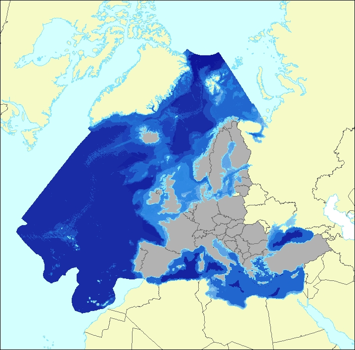
The data set aims to contribute to a better biological characterization of European marine ecosystems. As such it represents probabilities of EUNIS (EUropean Nature Information System) habitat presence at Level 3 for marine habitats including information on sea ice coverage (this corresponds to EUNIS level 2 for terrestrial habitats). The map combines spatially explicit data on marine bathymetry and sea-bed with non-spatially referenced habitat information of the EUNIS classification. The objective of the data set produced by EEA and its Topic Centre ETC/ULS is to improve the biological description of marine based ecosystem types and their spatial distribution. The work supports Target 2 Action 5 of the implementation of the EU Biodiversity Strategy to 2020, established to achieve the Aichi targets of the Convention of Biological Diversity (CBD). It further addresses the MAES process (Mapping and Assessing of Ecosystems and their Services). The data set represents 2 classes of the MAES classification level 3, namely “Marine inlets and transitional waters” and “Marine”. The dataset comprises the following information: • Sea region (1 – Arctic, 2 – Atlantic, 3 – Baltic, 4 – Mediterranean, 5 – Black Sea) • Sea zone (1 – Littoral, 2 – Infralittoral, 3 – Circalittoral, 4 – Offshore circalittoral, 5 – Upper bathyal, 6 – Lower bathyal, 7 – Abyssal,8 - Coastal Lagoons, 9 - Coastal Lagoons) • Substrate (0 – undetermined substrate, 1 – rock and biogenic, 3 – coarse sediment, 4 – mixed sediment, 5 – sand, 6 – mud) • Sea ice coverage (0 – no sea ice presence, 1 – seasonal sea ice presence, 2 – perennial sea ice presence)
-

Long term study of mixed forest of Pinus halepensis and Quercus ilex 55. Currently focused on carbon and water cycles, with routine measurements at the soil, plant, and ecosystem levels. Ecosystem manipulation consists in rainfall reduction and irrigation. Site is composed of : - a main enclosed area of 80x80 m ; - a 16 m tower supporting weather and eddy covariance measurements (ICOS level 2) - four 25x25 m plots (two inside and two outside the enclosed area) for 30% rainfall exclusion (with gutters), irrigation, control, and control with reversed gutters. In all plots, measurements are carried out for soil moisture, sap flow, stem diameter growth, leaf area index, litterfall, leaf water potential, and soil respiration.