 Metadata catalogue
digital elevation model
Type of resources
Available actions
Topics
Keywords
Provided by
Representation types
Update frequencies
status
-
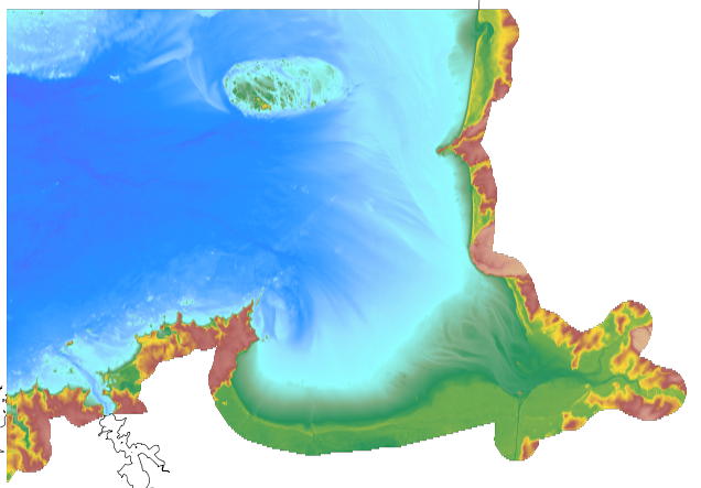
The coastal topo- bathymetric DEM of the port of Saint-Malo and its surroundings with a resolution of 0.00005° (~ 5 m) was prepared as part of the PAPI Saint-Malo. It covers the city of Saint-Malo and its surroundings, from the tip of Décollé in the west to the tip of Varde in the east. The DEM is designed to be implemented in the hydrodynamic models of the TANDEM project in order to estimate the coastal effects of tsunamis for the Atlantic and English Channel, where French nuclear power plants have been installed for about 30 years. This product is available with the Lowest Astronomic Tide (LAT) or the Mean Sea Level (MSL) as a vertical datum.
-
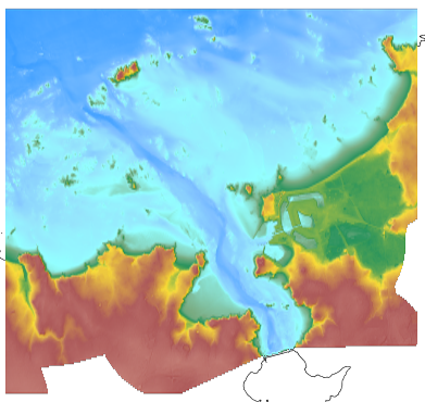
The coastal topo- bathymetric DEM of a part of the Norman-Breton gulf with a resolution of 0.0002° (~ 20 m) was prepared as part of the PAPI Saint-Malo. It covers the Minquiers plateau in the north-west to the bay of Mont-Saint-Michel in the south-east. The DEM is designed to be implemented in the hydrodynamic models of the TANDEM project in order to estimate the coastal effects of tsunamis for the Atlantic and English Channel, where French nuclear power plants have been installed for about 30 years. This product is available with the Lowest Astronomic Tide (LAT) or the Mean Sea Level (MSL) as a vertical datum.
-

The coastal topo-bathymetric DTM of the Arcachon basin and its surroundings at a resolution of 0.0002° (~ 20 m) was produced as part of the HOMONIM project. The DTM covers the coastline of a part of the Gironde department, from the Carcans and Hourtin ponds in the North, to the Cazaux and Sanguinet lakes in the South. It covers the entire Arcachon basin and extends offshore to about 40 m depth. The DTM is intended to be implemented in hydrodynamic models in order to produce accurate forecasts of water heights and sea states at the coast and to improve the French storm surge warning system. This product is available with the Lowest Astronomic Tide (LAT) or with the Mean Sea Level (MSL) as a vertical datum.
-

The bathymetric DEM for the coasts of New-Caledonia with a resolution of 0.001° (~ 100 m) was prepared in the framework of a Shom-IRD partnership as part of the TSUCAL project. The DEM covers the basin from New Caledonia in the west to the Vanuatu archipelago in the east. The DEM is designed to be used in hydrodynamic models in order to improve the pertinence of the Waves-Submersion monitoring programme.