 Metadata catalogue
administrative boundary
Type of resources
Available actions
Topics
INSPIRE themes
Keywords
Contact for the resource
Provided by
Years
Formats
Representation types
Update frequencies
status
Scale
Resolution
-
Boundary dataset depicting the Community Councils across South Ayrshire. Community Councils (CCs) are voluntary organisations set up by statute and run by local residents to act on behalf of their area. Their specific role can vary according to their local area’s needs.
-
Locality planning is a key element of Health & Social Care Integration and with the enactment of the Public Bodies (Joint Working) (Scotland) Act, 2014 has become a legal requirement in relation to the planning and delivery of heath and social care services. The legislation requires that South Ayrshire is divided into localities for the purpose of preparing a Strategic Plan. Each locality consists of a number of Neighbourhood Areas, each of which has a Neighbourhood Action Plan. Planning work at locality level will be informed, in part, by information on identified needs from each neighbourhood and by the priorities listed in Neighbourhood Action Plans.
-
Locality planning is a key element of Health & Social Care Integration and with the enactment of the Public Bodies (Joint Working) (Scotland) Act, 2014 has become a legal requirement in relation to the planning and delivery of heath and social care services. The legislation requires that South Ayrshire is divided into localities for the purpose of preparing a Strategic Plan. The South Ayrshire Health & Social Care Partnership Locality Boundaries dataset was created to meet this requirement.
-
Boundary dataset depicting the catchment area for Roman Catholic secondary schools across South Ayrshire.
-
All of South Ayrshire is divided into wards for local government elections; each ward elects three or four councillors who represent their area in the running of the Council.
-
Boundary dataset depicting the catchment area for Roman Catholic primary schools across South Ayrshire.
-

The map sheet: 1. Madagascar : limites administratives. Scale of 1:2 000 000. Date of publication: 1966.
-

The map sheet: 1. Gabon - circonscription des Adouma 1933. Scale of 1:500 000. Date of publication: 1933.
-
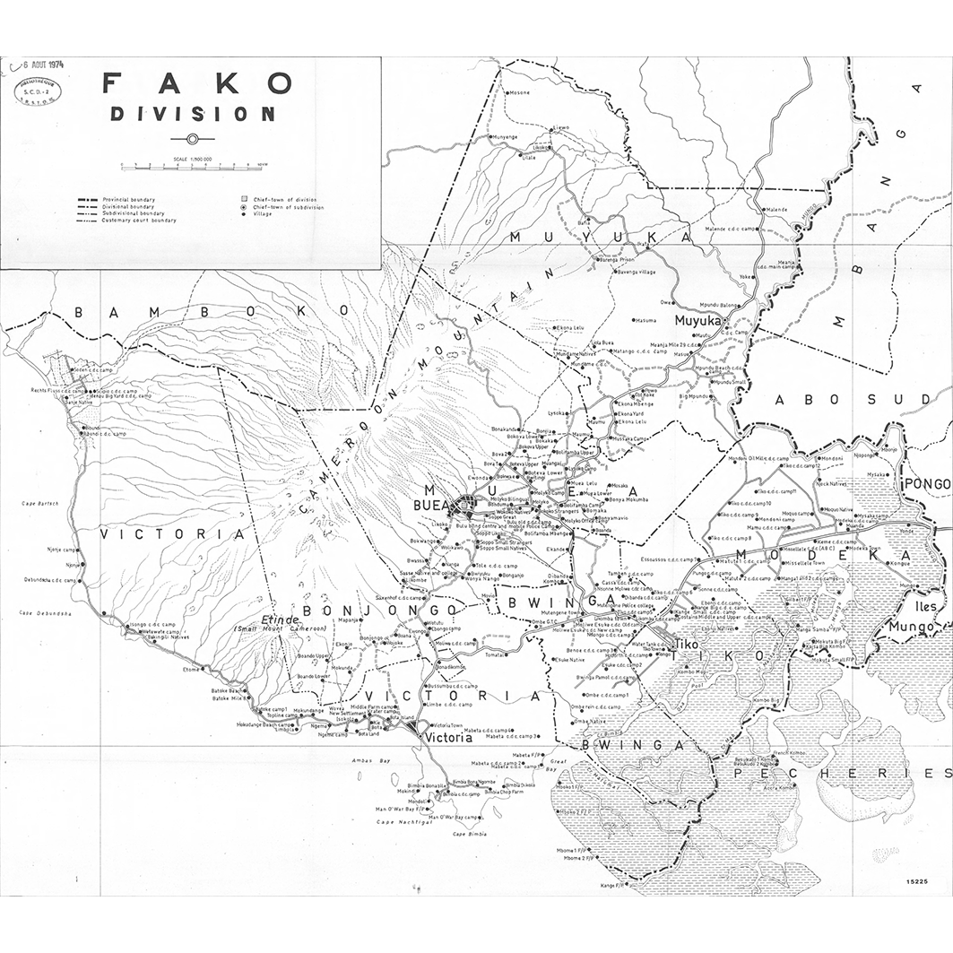
A set of 25 map sheets: 1. Bui division. Scale of 1:100 000. Date of publication: 1973. 2. Département Bamoun. Scale of 1:1 000 000 to 1:400 000. Date of publication: 1968. 3. Département de l'Adamaoua. Scale of 1:500 000. Date of publication: 1975. 4. Département de la Haute-Sanaga. Scale of 1:2 000 000 to 1:400 000. Date of publication: 1968. 5. Département de la Lekié. Scale of 1:100 000. Date of publication: unknown. 6. Département de la Mifi. Scale of 1:100 000. Date of publication: 1971. 7. Département de la Sanaga Maritime : arrondissements d'Édéa, Dizangue, Ngambe, Ndom, Pouma : district de Mouanko. Scale of 1:200 000. Date of publication: unknown. 8. Département des Bambouto. Scale of 1:500 000 to 1:200 000. Date of publication: 1968. 9. Département du Haut Nyong. Scale of 1:2 000 000 to 1:500 000. Date of publication: 1968. 10. Département du la Kadéi : arrondissements de Batouri et Ndélélé. Scale of 1:400 000. Date of publication: 1968. 11. Département du Margui Wandala. Scale of 1:200 000. Date of publication: unknown. 12. Département du Mayo Danaï. Scale of 1:200 000. Date of publication: 1972. 13. Département du Mbam : arrondissements de Bafia, Bokito, Ndikinimeki, Ntui : districts de Ngorro, Ombessa, Makenene, Deuk. Scale of 1:200 000. Date of publication: unknown. 14. Département du Mungo. Scale of 1:200 000. Date of publication: unknown. 15. Département du Ndé. Scale of 1:100 000. Date of publication: 1976. 16. Département du Nkam. Scale of 1:200 000. Date of publication: unknown. 17. Département du Ntem. Scale of 1:2 000 000 to 1:400 000. Date of publication: 1969. 18. Département du Nyong et Kellé : arrondissement de Bot Makak, de Makak et de Eseka : districts de Messondo, Matomb, Dibang, Ngog-Mapubi. Scale of 1:200 000. Date of publication: unknown. 19. Département du Wouri. Scale of 1:100 000 to 1:50 000. Date of publication: 1970. 20. Dictionnaire des villages de Kribi. Scale of 1:200 000. Date of publication: unknown. 21. Donga Mantung division. Scale of 1:200 000. Date of publication: 1973. 22. Fako division. Scale of 1:100 000. Date of publication: 1973. 23. Manyu division : carte provisoire. Scale of 1:200 000. Date of publication: 1974. 24. Meme division. Scale of 1:200 000. Date of publication: 1974. 25. Ndian division. Scale of 1:200 000. Date of publication: 1973.
-

The shapefile represents the administrative divisions of Adjumani district in the North of Uganda as of December 2001. The shapefile divides Adjumani district into 1 county. The county is subdivided into 5 subcounties and one town council. These, in turn have 15 subdivisions that are called parishes. The parishes are further subdivided into 73 villages. We digitized the administrative units from paper maps that we have received from Uganda Bureau of Statistics in Entebbe. The associated population size on village level represents the provisional result of the Uganda census 2002.