 Metadata catalogue
above ground biomass
Type of resources
Available actions
Topics
Keywords
Contact for the resource
Provided by
Years
Formats
Representation types
Update frequencies
status
Scale
-

A set of 3 map sheets: 1. Carte de l'occupation des terres : bassin versant de l'Oued El Hissiane. Scale of 1:10 000. Date of publication: 1978. 2. Carte des indices du biovolume végétal : bassin versant de l'Oued El Hissiane. Scale of 1:10 000. Date of publication: 1978. 3. Carte du recouvrement végétal : bassin versant de l'Oued El Hissiane. Scale of 1:10 000. Date of publication: 1978.
-
Africadiv is a network of 1-ha forest monitoring plots spread across the moist forests in central Africa. This dataset holds the biomass calculated from plot inventory data......
-
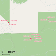
Africadiv is a network of 1-ha forest monitoring plots spread across the moist forests in central Africa. The Cameroonian site of Mindourou II is composed of 12 1-ha forest plots. The following data are available for the different plots at this site: Structure - DBH of all trees ≥ 10 cm DBH : n = 5 598 Structure - Tree height : n = 920 Structure - Trunk height : n = 667 Structure - Crown diameter : n = 233 Identification rate - species-level : 56.4 % Identification rate - genus-level : 26.2 % Identification rate - family-level : 11.7 % Identification rate - unidentified : 5.7 % Soil samples & analyses available : YES Geolocation : GPS points and laser measurements (distance, vertical & horizontal angles) every 20 m on the contour of the plot. These data are routinely collected and used by AMAP research unit (IRD) and partners (LaboSyst, Yaoundé 1 University). Scientific collaboration are welcomed, please get in touch with a Point of contact.
-

This “Inventaire Papetier” was conducted by ONF in 1976. The block covers 22 087 ha. 54 020 trees have been inventoried in 235 plots (164 ha) Pre-census DBH is 10 cm on one plot out of two and 40 cm on the others. DBH have been measured by classes with a range of 10 cm. Plots have been located on GIS in 2010 using original maps and field note-books (indicating slopes, rivers, etc...).
-

This “Inventaire Papetier” was conducted by the CTFT in 1975. The block covers 59 895 ha. 34 016 trees have been inventoried in 244 plots (120 ha) Pre-census DBH is 15 cm on all plot (originally trees with DBH 10-15cm have been measured on one plot out of 10 but not included in the digital version) DBH have been measured by classes : 15-20 cm for the first class and with a range of 10 cm since 20 cm. Plots have been located on GIS in 2008 using original maps and field note-books (indicating slopes, rivers, etc...).
-

This “Inventaire Papetier” was conducted by the CTFT in 1975. The block covers 18 737 ha. 17 560 trees have been inventoried in 80 plots (40 ha). Pre-census DBH is 10 cm on all plot. DBH have been measured by classes with a range of 10 cm. Plots have been located on GIS in 2006 using original maps and field note-books (indicating slopes, rivers, etc...).
-

This “Inventaire Papetier” was conducted by the CTFT in 1975. The block covers 63 128 ha. 58 451 trees have been inventoried in 250 plots (123 ha) Pre-census DBH is 10 cm on all plot DBH have been measured by classes with a range of 10 cm since 20 cm. Plots have been located on GIS in 2006 using original maps and field note-books (indicating slopes, rivers, etc...).
-

This “Inventaire Papetier” was conducted by the CTFT in 1975. The block covers 23 706 ha. 11 427 trees have been inventoried in 97 plots (47 ha) Pre-census DBH is 10 cm on one plot out of 10 and 15 cm in the others. DBH have been measured by classes : 10-20 cm or 15-20 cm for the first class and with a range of 10 cm since 20 cm. Plots have been located on GIS in 2006 using original maps and field note-books (indicating slopes, rivers, etc...).
-

This “Inventaire Papetier” was conducted by the CTFT in 1975. The block covers 78 255 ha. 47 205 trees have been inventoried in 317 plots (152 ha) Pre-census DBH is 15 cm on all plot (originally trees with DBH 10-15cm have been measured on one plot out of 10 but not included in the digital version) DBH have been measured by classes : 15-20 cm for the first class and with a range of 10 cm since 20 cm. Plots have been located on GIS in 2009 using original maps and field note-books (indicating slopes, rivers, etc...).
-

This “Inventaire Papetier” was conducted by the CTFT in 1975. The block covers 40 556 ha. 25 735 trees have been inventoried in 169 plots (82 ha) Pre-census DBH is 15 cm on all plot (originally trees with DBH 10-15cm have been measured on one plot out of 10 but not included in the digital version) DBH have been measured by classes : 15-20 cm for the first class and with a range of 10 cm since 20 cm. Plots have been located on GIS in 2009 using original maps and field note-books (indicating slopes, rivers, etc...).