Metadata catalogue
Waves
Type of resources
Available actions
Topics
INSPIRE themes
Keywords
Contact for the resource
Provided by
Years
Formats
Representation types
Update frequencies
Resolution
-
During the SARDINIA experiment, CHIRP profiles, bathymetry data, three coincident MCS reflection and wide-angle seismic profiles, and one single MCS reflection profile were collected on the West Sardinia margin. The MCS reflection data was acquired using a 4.5 km 360-trace digital streamer and a tuned airgun array of 8260 cubic inches, which was towed at a depth of 18-28 m. A total of 48 ocean bottom seismometers/hydrophones (OBS/OBH) from Ifremer, University of Brest, and Geomar Kiel were deployed on the West Sardinia margin, spaced every 7 nmi (~13 km). In five locations, three OBS were deployed at the same place to ensure the collection of data. The airgun array consists of 16 airguns ranging from 100 cubic inch G-guns to 16 L Bolt airguns, with main frequencies centered around 10-15 Hz. The airguns were tuned to the first bubble, to enhance low frequencies and ensure deep penetration. The shot interval was 60 s at an average speed of 5 knots, which translates to a trace spacing of about 140-150 m. The sample rate was 8 ms for the micrOBS, 5 ms for the Geomar, and 4 ms for the OldOBS. A total of 3573 shots (profile GH: 1130, profile G2H2: 1214) were fired by the air gun array. Profiles GH and G2H2, which are 160 and 200 km long transects, respectively cross the West Sardinia margin from the continental shelf to the “atypical” oceanic crust. Twenty-one ocean bottom seismometers (OBS) were deployed on the G2H2 profile, whereas sixteen were deployed on the GH profile. Additionally, the shots on this profile were recorded by eight land seismic stations (OSIRIS stations from the University of Brest and Geosciences Azur) that extended the marine profile ~150 km onshore. For the two profiles only 33 instruments were used in the wide-angle modeling, since four instruments (OBSS06, 18a, 30a, and 30c) did not record properly. We propose here the velocity models (v.in files) of the 2 main profiles located on the West sardinian margin, Profile K7L2, located on the shelf and parallel to the margin, is not presented since most of the deep arrivals are masked by the presence of sea-bottom multiples, preventing an accurate wide-angle model.
-

During the SARDINIA experiment, three coincident MCS reflection and wide-angle seismic profiles, sub-bottom high resolution (CHIRP) profiles, and bathymetry data were collected on the Gulf of Lion margin. The seismic reflection data were acquired using a 4.5 km, 360 trace digital streamer and a tuned airgun array of 8260 in3, towed at a depth of 18-28 m. A total of 57 ocean bottom seismometer/ hydrophones (OBS/OBH) from Ifremer, University of Brest, and Geomar Kiel were deployed in the Gulf of Lion, spaced every 7 Nm (~13 km). The airgun array consists of 16 airguns ranging from 100 in3 G-guns to 16 L Bolt airguns, with main frequencies centered around 10-15 Hz. The airguns were tuned to the first bubble to enhance low frequencies and ensure a good penetration. The shot interval was 60 s at an average speed of 5 knots, which translates to a trace spacing of about 140-150 m. The sample rate was 8 ms for the micrOBS, 5 ms for the Geomar’s OBS and 4 ms for the OldOBS. A total of 6160 shots (profile AB: 3032, profile CD: 1730, profile EF: 1398) were fired by the air gun array. Profile AB crosses the Gulf of Lion’s margin, parallel to the ECORS profile, from the continental shelf to Domain III. Twenty-five ocean bottom seismometers (OBS) were deployed on this profile, of 467 km in length. Twenty-two instruments were used in the wide-angle modelling, since three instruments (OBS 45, 49 and 52) did not properly record. The shots on this profile were additionally recorded by 9 land seismic stations (OSIRIS stations from the University of Brest and Geosciences Azur) that have extended the marine profile ~120 km onshore. Profiles CD and EF are 250 and 210 km long transects parallel to the margin. Profile CD was acquired using 19 OBS of which 18 yielded usable data. Profile EF was acquired using 15 OBS of which 12 yielded usable data. These two profiles cross the profile AB, respectivelyat OBS 26 and OBS 8.
-
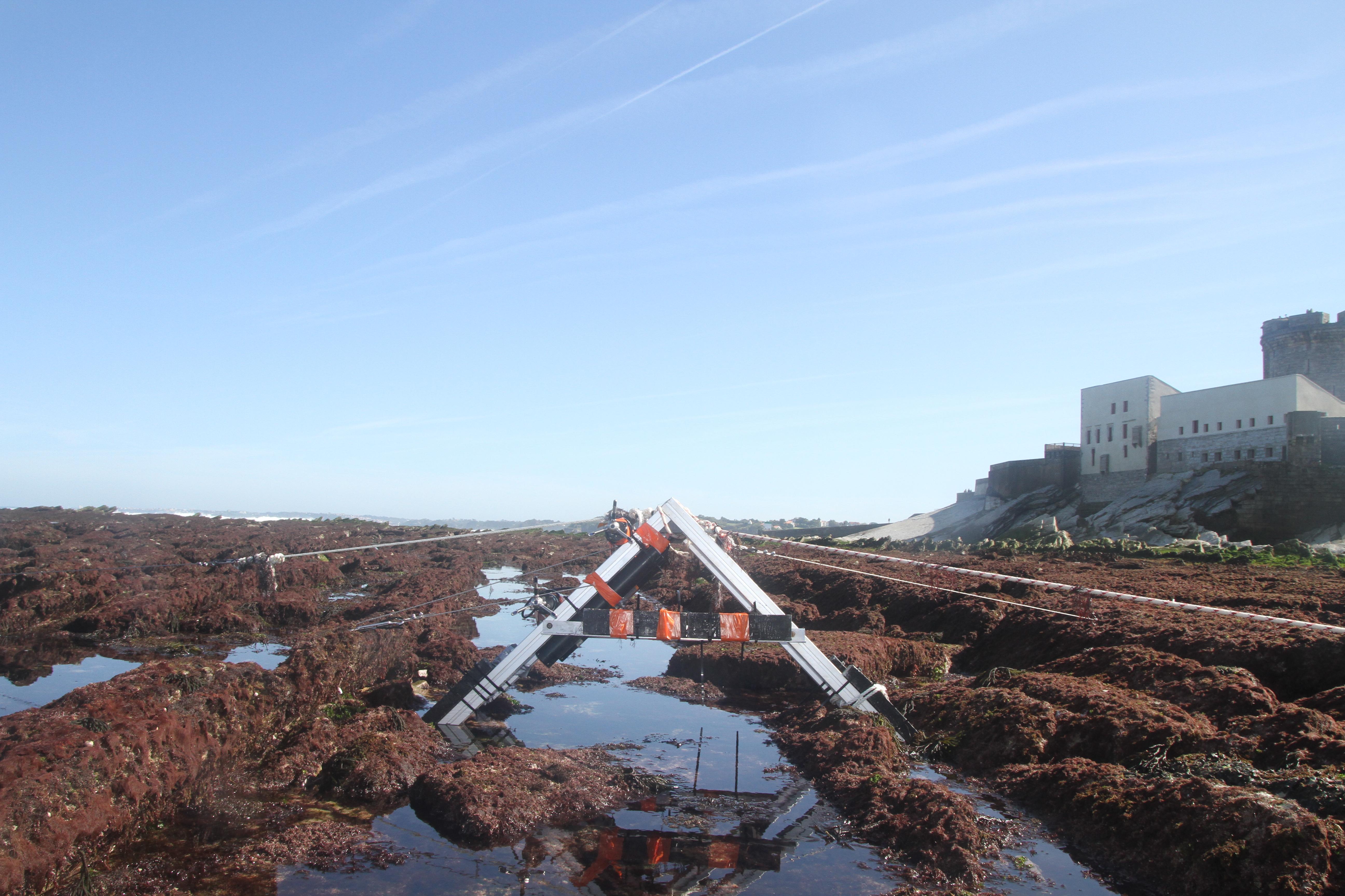
The database displays the field measurements recover during a one-week experiment in October 2021 on the Socoa's rocky platform, France. The general objective of the study was to evaluate the momentum balance over the rocky platform, in particular to quantifiy the combined effect of high seabed roughness and waves on the coupling between circulation, wave force and mean water level. The analysis is performed along a single cross-shore transect. The data include: - the cross-shore bathymetric profile - the time-series of integrated wave parameters, local mean water depth and wave-averaged currents over successive 30-min bursts - the depth- and wave-averaged momentum fluxes following the formulation proposed by Smith 2006 and Bruneau et al. 2011. The fluxes are median values obtained over significant wave height to depth ratio bins
-
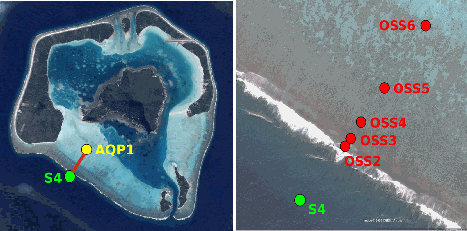
Maupiti ("the Stuck Twins'') is a diamond-shaped island located in the western part of the Society archipelago in French Polynesia. The present study focuses on the data recovered over a single cross-barrier transect located in the south-west barrier during the MAUPITI HOE field campaign, from 5 to 18 July 2018. The studied area is representative of the reef structure observed along the 4km-long southwestern barrier reef, showing an alongshore-uniform structure exposed to swell approaching with weak incident angles, a healthy reef colony. In the cross-barrier direction, the reef displays a clear partitioning of bottom roughness that ranges from low-crested compact structures at the reef crest to higher and sparser coral bommies on the backreef. The experimental setup was specifically designed to analyse and differentiate the dynamics over three roughness-contrasting sections found over the barrier reef.
-